Severe storms with nocturnal tornado risk to blitz over a dozen states
|
Millions of people in the central and eastern United States are bracing not only for severe storms and tornadoes, but also weather whiplash with temperatures plummeting as much as 60 degrees in less than 24 hours during the middle of this week. |
|||
February 26, 2024
AccuWeather Global Weather Center – February 26, 2024
The upcoming severe thunderstorms, which may affect as many as 50 million people, have been on AccuWeather's radar for at least a week due to a potent storm the team has been tracking since it began its journey well out over the Pacific Ocean. As that storm interacts with a strong jet stream, surging Gulf of Mexico moisture and an increasing temperature difference between unusual warmth and February cold, natural fireworks in the form of powerful thunderstorms will unfold.
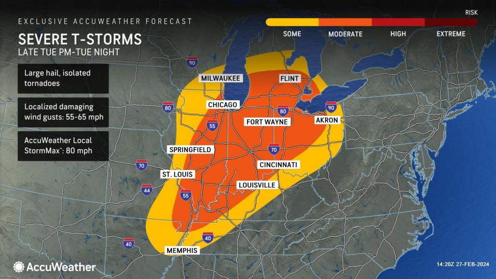
"The first thunderstorms will erupt along the edge of advancing warm air from mid-to late afternoon on Tuesday from northern Illinois and Indiana to southern Wisconsin and Michigan, as well as northwestern Ohio," AccuWeather Meteorologist Alyssa Glenny said. These storms will become severe toward the end of the day.
Next, thunderstorms will explode southwestward along the advancing cold front, extending from northern Illinois to Arkansas Tuesday evening. The front and the severe weather it packs will move across the Ohio and the middle Mississippi valleys during the overnight hours on Tuesday.
All modes of severe weather are anticipated with this severe weather risk. Some of the storms will pack damaging wind gusts, large hail and torrential downpours capable of leading to flash flooding. However, the potential for multiple tornadoes is also a serious concern with the upcoming severe weather threat, especially those happening at night.
AccuWeather Chief Meteorologist Jonathan Porter shared, “This is really a springtime setup, as opposed to a February setup. We want you to make sure you let your friends and family know about the risk.” Porter added, “The severe weather risk can ramp up after dark. Of course, most people are sleeping at night. Tornadoes that happen at night are two times more likely to be fatal than tornadoes that occur during the day; that’s why it’s such a concern.”
Also, according to Porter, “Have your shelter or safe place ready for tornado warnings. “You want to be able to move there quickly, especially with an overnight threat. You want to be in the lowest part of your home. You want to be in an interior room, a basement if you have it.”

"The greatest threat of tornadoes may occur along and in between interstates 70 and 80 in the Midwest, beginning in Illinois and western Indiana late in the day Tuesday and expanding eastward from there Tuesday night," AccuWeather StormWarning Meteorologist Joseph Bauer said.
The Tuesday evening and night tornado threat includes the massive Chicago and St. Louis metro areas and the cities of Indianapolis, South Bend and Fort Wayne, Indiana; Toledo and Lima, Ohio; and Springfield and Peoria, Illinois.
Should the severe thunderstorms organize into a single solid line on Tuesday night, the risk of damaging wind gusts may broaden, but the risk of highly dangerous tornadoes may lower. While a line of storms may form, it may be fragmented and individual discrete thunderstorms, which are most capable of producing tornadoes, may proceed the line.
AccuWeather meteorologists urge people in the path of the storms to pay attention to severe weather bulletins, including signing up for alerts that may precede the messages when sleeping at night, such as the AccuWeather App.
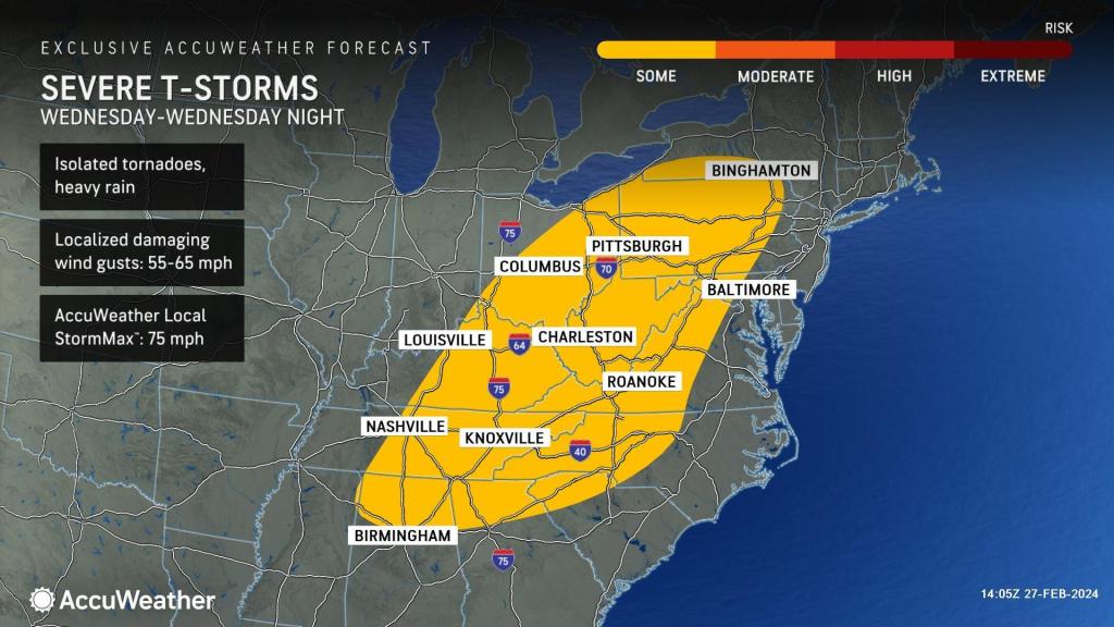
The risk of severe thunderstorms, including a few tornadoes, will carry over into Wednesday as the cold front advances to the east and south toward the central and southern Appalachians. On Wednesday, the severe weather threat will extend from southern New York state to the northern parts of Mississippi, Alabama and Georgia.

The potential for storms capable of causing property damage and localized power outages on Wednesday will include New York City, Philadephia, Washington, D.C., Charlotte and part of the Atlanta metro area.
As the powerful cold front presses on toward the mid-Atlantic coast, storms will bring brief downpours and strong wind gusts, as opposed to a tornado threat. In some cases, the squally storms may occur without thunder and lightning by the time the storms reach the coast, Bauer said.
Powerful cold front to mark as much as 60-degree temperature crash
One of the reasons for the severe weather will be the rapid exchange of warm and cold air. Temperatures more typical of May and early June will precede the cold front, including unusual warmth at night into Tuesday in the Central states and into Wednesday along the Atlantic and Gulf coasts.
Widespread highs in the 60s and 70s across the north and the 70s and 80s across the south are in store ahead of the front. Nighttime lows will be in the 40s and 50s across the north and the 50s and 60s across the south for the first part of this week.
Temperatures will range from 15-30 degrees Fahrenheit above the historical average in many areas but may reach 60 degrees in some places through Tuesday in the central states and from Tuesday to Wednesday along the Atlantic and Gulf coasts.
In the wake of the front, from Tuesday to Wednesday night, temperatures will crash 40 degrees over a broad area in a matter of hours.
"For example, at Kansas City, Missouri, temperatures may drop about 60 degrees in 18 hours, which could set a record," AccuWeather Meteorologist and Social Media Producer Jesse Ferrell stated. The existing record is 56 degrees, set on Jan. 15, 1953.
In some cases, such as parts of the central Plains, the Upper Midwest, the Appalachians and New England, the blast of cold air will be so rapid as to catch up with the lingering moisture in the wake of the front. This temperature plunge will lead to pockets of accumulating snow and/or a rapid freezeup where moisture and slush can freeze into sheets of ice within an hour.
The flash freeze will spread eastward across the Upper Midwest Tuesday night and from the central Appalachians to New England Wednesday evening and night.
In most cases along the mid-Atlantic and southern New England coasts, gusty winds will dry off roads and sidewalks Wednesday night, but there may be a few exceptions, and caution is advised.


