


AccuWeather meteorologists are available 24/7 to provide further insights and updates on evolving weather conditions. Please contact pr@accuweather.com during regular business hours, or support@accuweather.com or call AccuWeather’s Media Hotline at (814)-235-8710 at any time to arrange interviews with AccuWeather experts or to request the most updated graphics for print or broadcast.
Dangerous impacts expected after dark as Hurricane Francine slams the U.S. Gulf Coast
Sept. 11, 2024

>  Hurricane-force wind gusts could reach western parts of the New Orleans metro

> Increased risk of tornadoes embedded in rainbands east of the storm track

> Flooding risk expands from the Gulf coast into parts of the Mississippi and
western Tennessee Valleys this week
AccuWeather Global Weather Center – Sept. 11, 2024
Flash flooding, destructive winds, life-threatening storm surge, and the threat of spin up tornadoes will impact coastal Louisiana as Hurricane Francine approaches the Gulf coast.
“We’re concerned about the risk of damaging wind gusts and extended power outages as the strongest winds from Francine track dangerously close to New Orleans and Baton Rouge,” said AccuWeather Chief Meteorologist Jon Porter. “The winds will be powerful enough to take down power lines and trees, especially since the ground is saturated from recent rainfall before Francine arrived.”
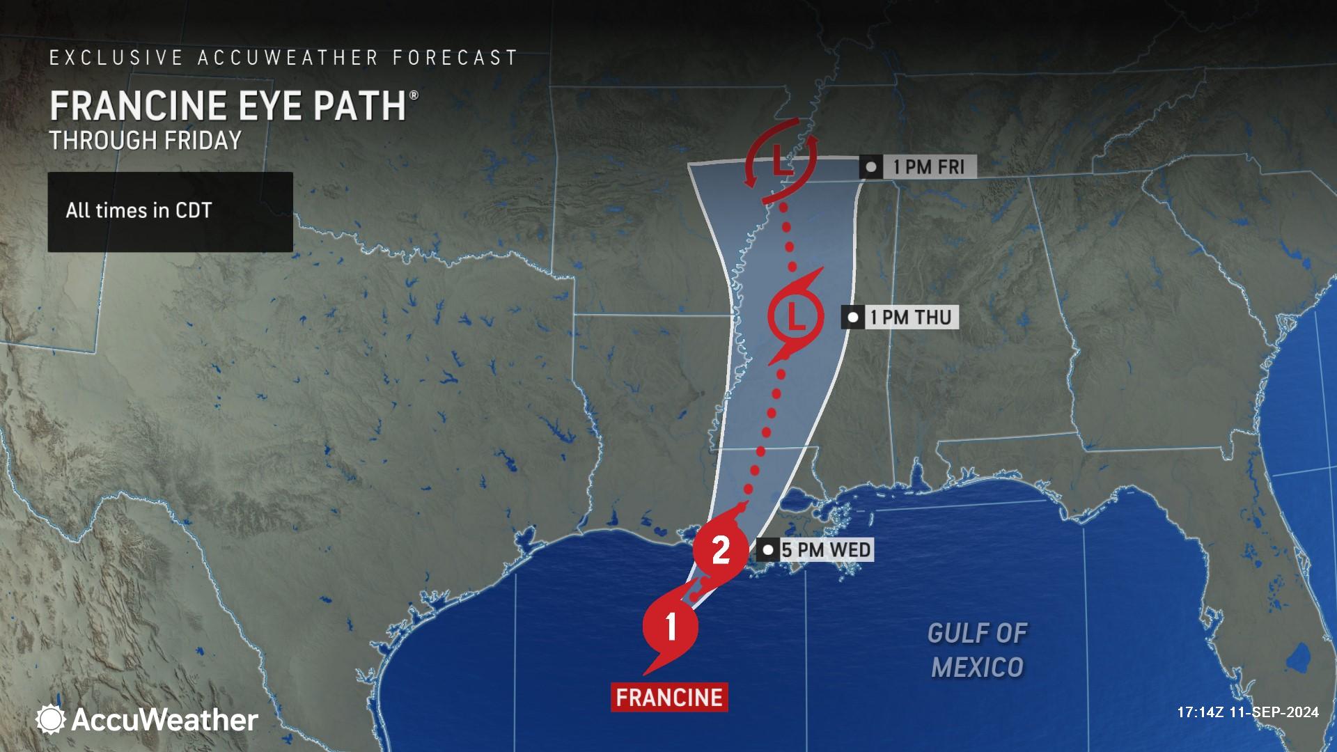
AccuWeather is forecasting Francine to make landfall this afternoon as a Category 2 hurricane with maximum sustained winds of 96-110 miles on the Saffir-Simpson hurricane wind scale.
“Storms over Texas are helping to enhance a lifting motion in the atmosphere, helping Francine to maintain its strength and potentially intensify right before landfall,” Porter explained. “We’re seeing more lightning in the eyewall, which is another sign of an intensifying hurricane.”
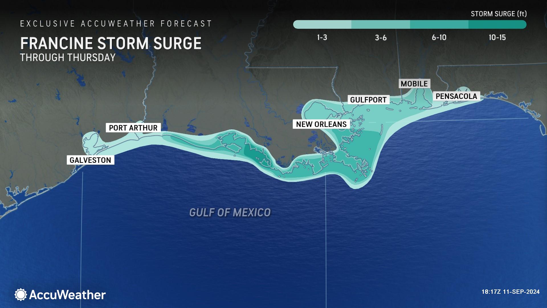
AccuWeather expert meteorologists are forecasting 6-10 feet of storm surge along parts of the Louisiana coast, with up to 15 feet of storm surge possible where Francine makes landfall. Storm surge is a rapid rise in water that inundates areas along the coastline and can be deadly.
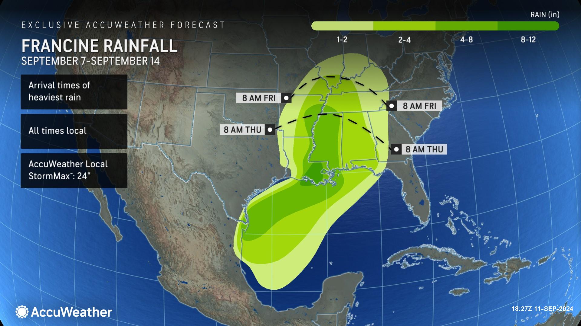
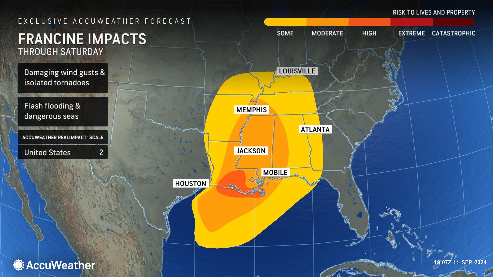
The heaviest rainfall of 8-12 inches is expected in the area where Francine makes landfall in south-central Louisiana, with an AccuWeather Local StormMax™ of 24 inches. This intense rainfall can cause significant flash flooding that can lead to structural damage and road closures. River flooding is also possible going into the weekend.
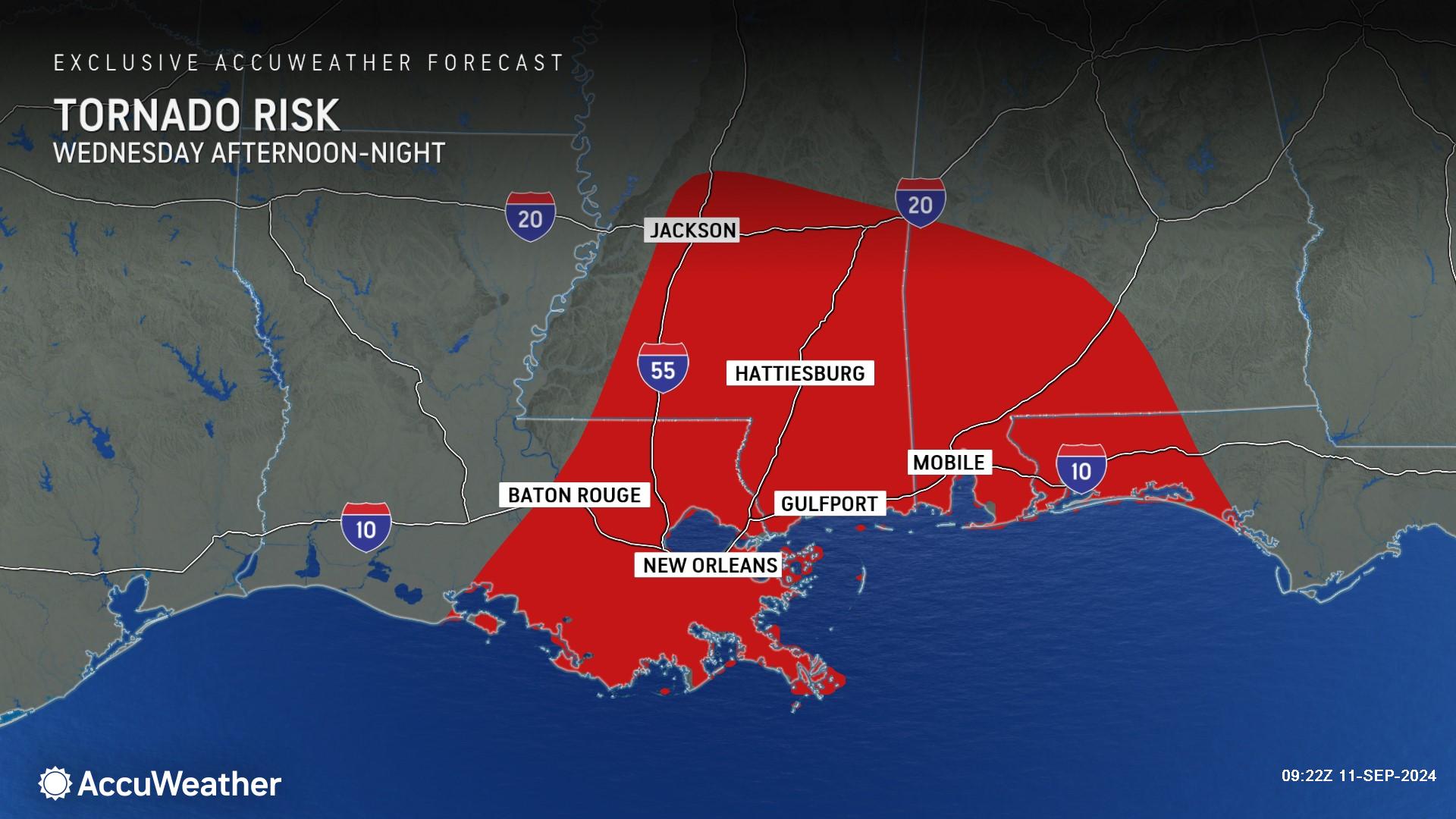
AccuWeather expert meteorologists say there is also a risk of several tornadoes embedded in rain bands.
“Nocturnal tornadoes are extremely dangerous, especially when they are embedded in tropical rainbands. Tornadoes can be nearly impossible to see in the dark, especially if they’re wrapped in rain,” Porter warned. “Navigating through damage and debris in the dark is dangerous for storm survivors and first responders. It is critical for people to keep cell phones charged to receive potentially life-saving alerts from the AccuWeather app.”
Porter says people should stay indoors, away from windows, and avoid travel during the worst impacts of the storm.
Powerful wind gusts of 100-120 mph can occur near where the center of the storm moves onshore, with an AccuWeather Local StormMax™ of 130 mph. Hurricane-force winds can damage homes and businesses, sending dangerous debris flying through the air, which can compound the impacts and safety hazards.
“Batten down the hatches in Baton Rouge, get ready for up to six hours of powerful wind gusts and flooding rainfall,” warned AccuWeather Chief On-Air Meteorologist Bernie Rayno. “Conditions can be incredibly dangerous after dark.”
Heavy rain from Francine will continue to spread northward across Louisiana and the lower Mississippi Valley, extending into the central Mississippi and Ohio valleys throughout the rest of the week as Francine progresses northward. Rainfall totals of 1-2 inches are expected through much of the northern Gulf Coast and lower Ohio Valley. An area of 2-4 inches will extend through the panhandle of Florida, Alabama, Mississippi and southern Missouri.
AccuWeather Lead Hurricane Expert Alex DaSilva says Francine was able to intensify over the past 24 hours over the exceptionally warm waters of the Gulf of Mexico.
“Francine has been fending off the dry air with its strong core. We saw a bit of dry air pulled into the storm early this morning, then a blowup of thunderstorms kicked the dry air back out,” DaSilva explained.
AccuWeather expert meteorologists are concerned that flooding rainfall could extend well inland through Thursday night.
“A strong dip in the jet stream that is guiding the hurricane to the northeast will help squeeze additional moisture out of the atmosphere over Louisiana,” said DaSilva.
Francine is a 2 on the AccuWeather RealImpact™ Scale for Hurricanes in the United States due to expected significant storm surge flooding of up to 15 feet, inland rainfall flooding due to up to a foot or more of rain, and damaging winds that can damage buildings, take down trees and power lines and potentially lead to extensive and extended power outages.
In contrast to the Saffir-Simpson Hurricane Wind Scale, which classifies storms by wind speed only, the AccuWeather RealImpact™ Scale is based on a broad range of important factors. In order to better communicate a more comprehensive representation of the potential impact of a storm on lives and livelihoods, the scale covers not only wind speed, but also flooding rain, storm surge and economic damage and loss. Some of these hazards, such as inland flooding and storm surge in many storms, result in more deaths and economic loss than wind.
AccuWeather was the first known source to issue a forecast track and intensity forecast for this tropical threat Saturday afternoon, roughly 24 hours before the National Hurricane Center issued its first forecast track Sunday afternoon.
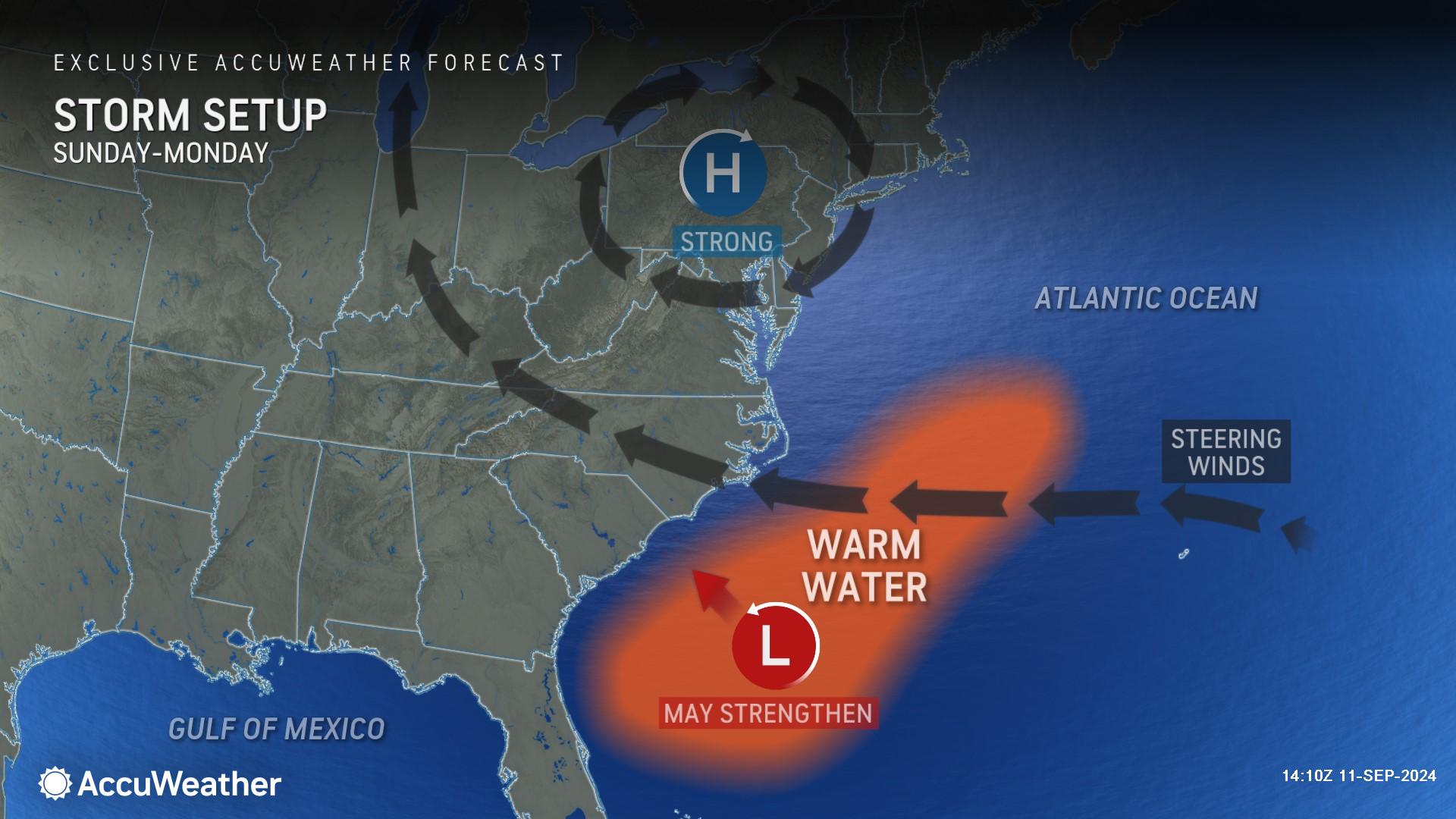
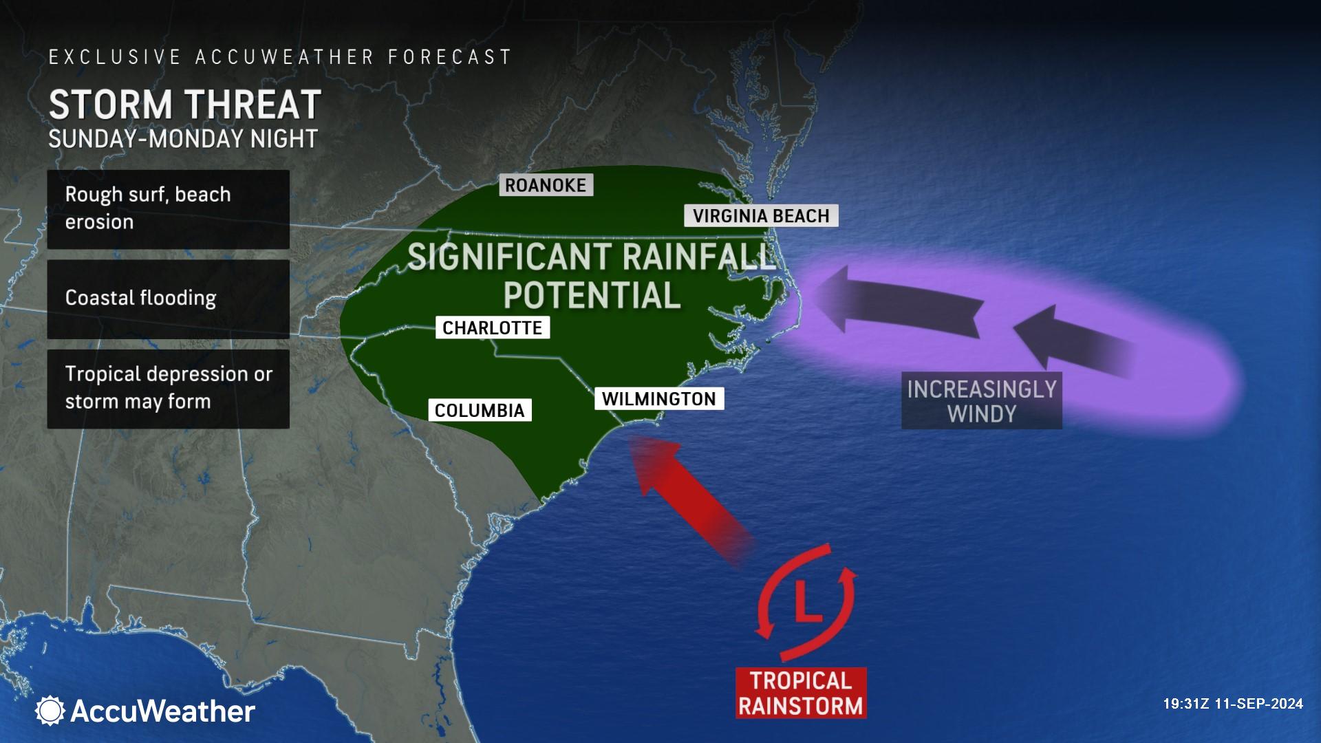
As Francine loses wind intensity and tracks inland over the interior Central states, AccuWeather expert meteorologists say a new tropical concern may spin up just off the Carolina coast this weekend.
There is a medium risk of this threat evolving into a tropical storm this weekend and drifting inland over the Southeastern states early next week, packing torrential rain, severe thunderstorms and strong winds. The next name on the list of Atlantic tropical storms is Gordon.
“We’re expecting conditions across much of the Atlantic basin to become more conducive for tropical development in the coming weeks,” said DaSilva. “Waters temperatures are extremely warm right now. People need to be prepared for potential tropical threats that can rapidly intensify into a tropical storm or a hurricane in just a few days.”
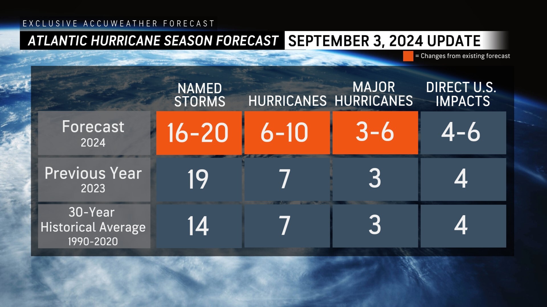
AccuWeather was the first known source to reduce the forecast for the number of named storms, hurricanes and major hurricanes expected during the 2024 Atlantic Hurricane season following the first Labor Day weekend without a named storm in decades.
AccuWeather Forecast Graphics
Additional AccuWeather Resources:
Hurricane Tracking & Storm Radar
Hurricane Francine bearing down on Louisiana; Landfall early Wednesday evening
LIVE: Hurricane warning in Louisiana as Francine nears US
5 reasons behind the historic absence of tropical storms this hurricane season
AccuWeather Reduces Forecast for Number of Named Storms and Hurricanes During 2024 Atlantic Hurricane Season
Rapidly Intensifying Hurricanes Near Coastline Pose Major Threat To US This Season


