AccuWeather meteorologists are available 24/7 to provide further insights and updates on evolving weather conditions. Please contact pr@accuweather.com during regular business hours, or support@accuweather.com or call AccuWeather’s Media Hotline at (814)-235-8710 at any time to arrange interviews with AccuWeather experts or to request the most updated graphics for print or broadcast.
Multi-Day Threat Of Tornadoes And Damaging Thunderstorms Returns To The Central U.S. Starting Monday
|
The severe weather threat including tornadoes, damaging wind, and large hail looms for the Central United States starting Monday.
|
|||
April 12, 2024
AccuWeather Global Weather Center – April 12, 2024
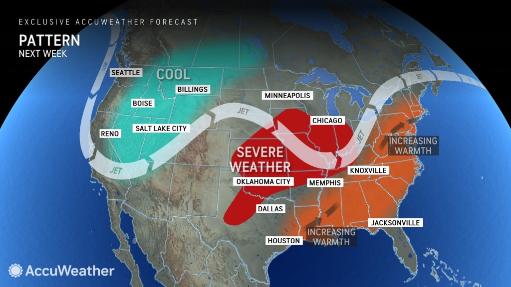
Warm and humid air moving in from the south is forecast to clash with cooler and drier air approaching from the northwest, sparking thunderstorms in more than a dozen states early next week.

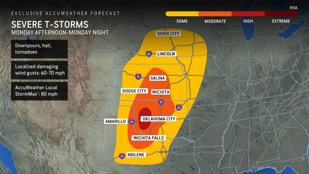
HIGH RISK FOR SEVERE THUNDERSTORMS MONDAY
The severe weather threat will start Monday afternoon as thunderstorms are forecast to develop from the Texas Panhandle northward along the Plains to Nebraska. Storms will then move east Monday night, through the Missouri River Valley and Iowa, as well as parts of Kansas, Oklahoma and northern Texas.
While the entire zone from central Texas to Iowa is at some risk for severe thunderstorms, AccuWeather expert meteorologists are growing increasingly concerned of a significant risk for tornadoes, damaging winds, and large hail in western Oklahoma. Although the exact location of the highest risk may shift as Monday approaches, the atmospheric conditions are favorable across Kansas and Oklahoma for numerous severe thunderstorms.
AccuWeather expert meteorologists also say the Oklahoma City and Wichita metro areas are included in the risk of flooding downpours, hail, damaging wind gusts, and even tornadoes.

“It looks like the southern Plains could really get hit hard with these storms. There will be plenty of warmth ahead of these storms to set the stage for Monday. It’s a pretty large area from Sioux City, Iowa to Abilene, Texas,” said AccuWeather Chief On-Air Meteorologist Bernie Rayno. “All forms of severe weather are possible from Salina and Wichita in Kansas, to Oklahoma City and Wichita Falls in Texas.”
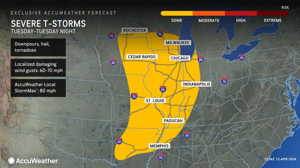
THUNDERSTORM THREAT SHIFTS NORTH & EAST ON TUESDAY
The threat of severe thunderstorms will move farther north and east to portions of the Mississippi Valley, Ohio Valley, and Midwest on Tuesday and Tuesday night. The Chicago, Memphis, and St. Louis metro areas face the threat of thunderstorms with hail and damaging wind gusts. The tornado risk is expected to persist as well.

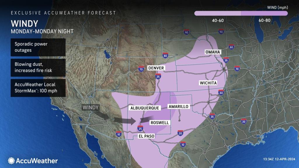
POWERFUL WIND GUSTS
AccuWeather expert meteorologists are concerned about the threat of strong wind gusts as the storm system emerges from the Rockies into the Plains early next week. Dangerous travel conditions are possible from Arizona to Nebraska. Blowing dust can quickly drop visibility along roads and highways. Strong wind gusts could also lead to power outages and the threat of new wildfires sparking and spreading.

Flight delays and cancellations are also possible early next week at several major airports and hubs, including Dallas Fort Worth International Airport, Chicago O’Hare International Airport, and St. Louis Lambert International Airport.
AccuWeather expert meteorologists encourage people who live, work, and travel through these areas to be prepared and have multiple ways to receive severe weather alerts, including push notifications from the AccuWeather app.
Additional AccuWeather Resources:


