


AccuWeather meteorologists are available 24/7 to provide further insights and updates on evolving weather conditions. Please contact pr@accuweather.com during regular business hours, or support@accuweather.com or call AccuWeather’s Media Hotline at (814)-235-8710 at any time to arrange interviews with AccuWeather experts or to request the most updated graphics for print or broadcast.
Summer heat vanishes from the Northeast as 10 Southern states bake under heat alerts
August 15, 2024

> Cooler and less humid air may linger across much of the Northeast for the
next 7-10 days
> More than 43 million Americans from Texas to Tennessee and Mississippi
are under heat warnings and advisories today
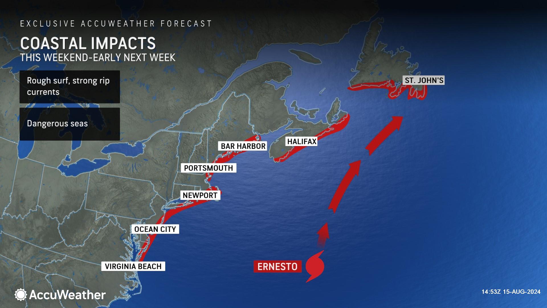
> Families headed to Atlantic beaches should be prepared for rough surf and
rip currents through the weekend as Hurricane Ernesto churns well offshore
AccuWeather Global Weather Center – August 15, 2024
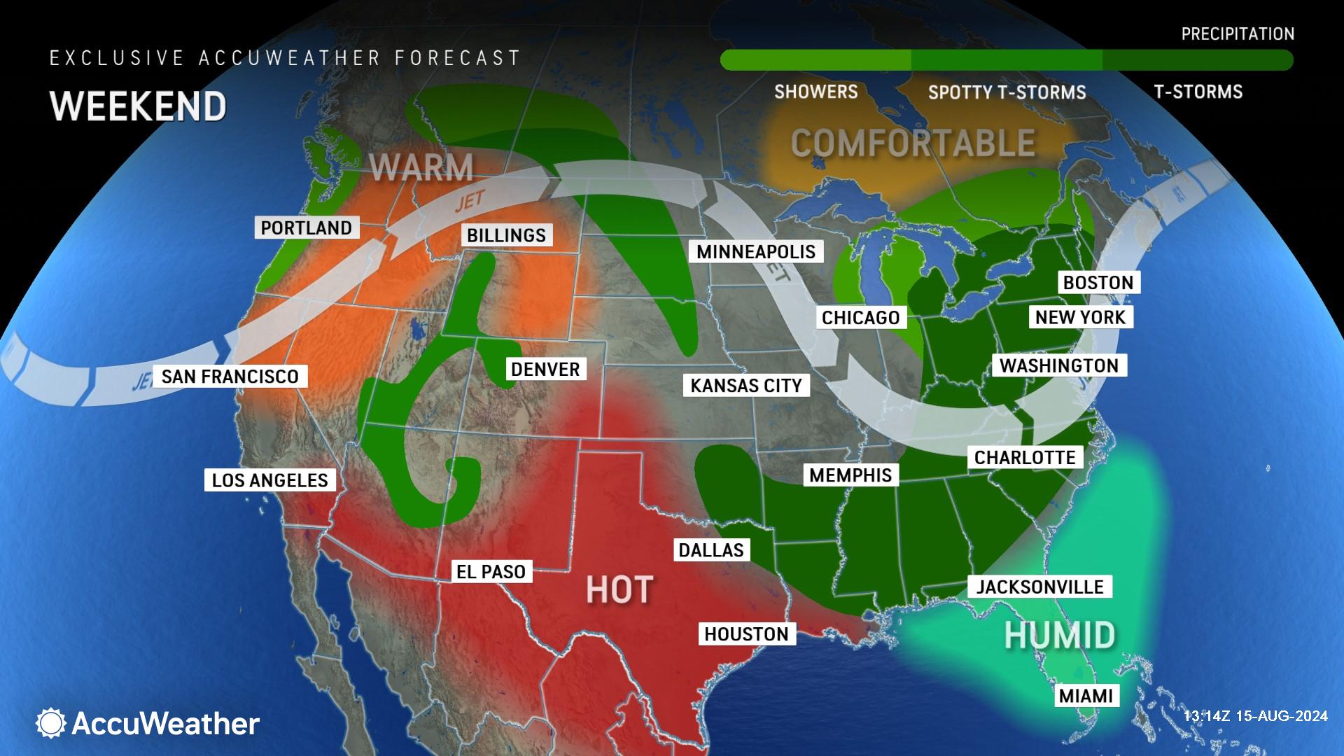
AccuWeather expert meteorologists say millions of people in the Northeast are getting a break from the heat and humidity following record-shattering temperatures and heat waves during the month of July.
While many people in the Northeast are enjoying cooler and less humid conditions, intense heat continues to grip the southern United States.
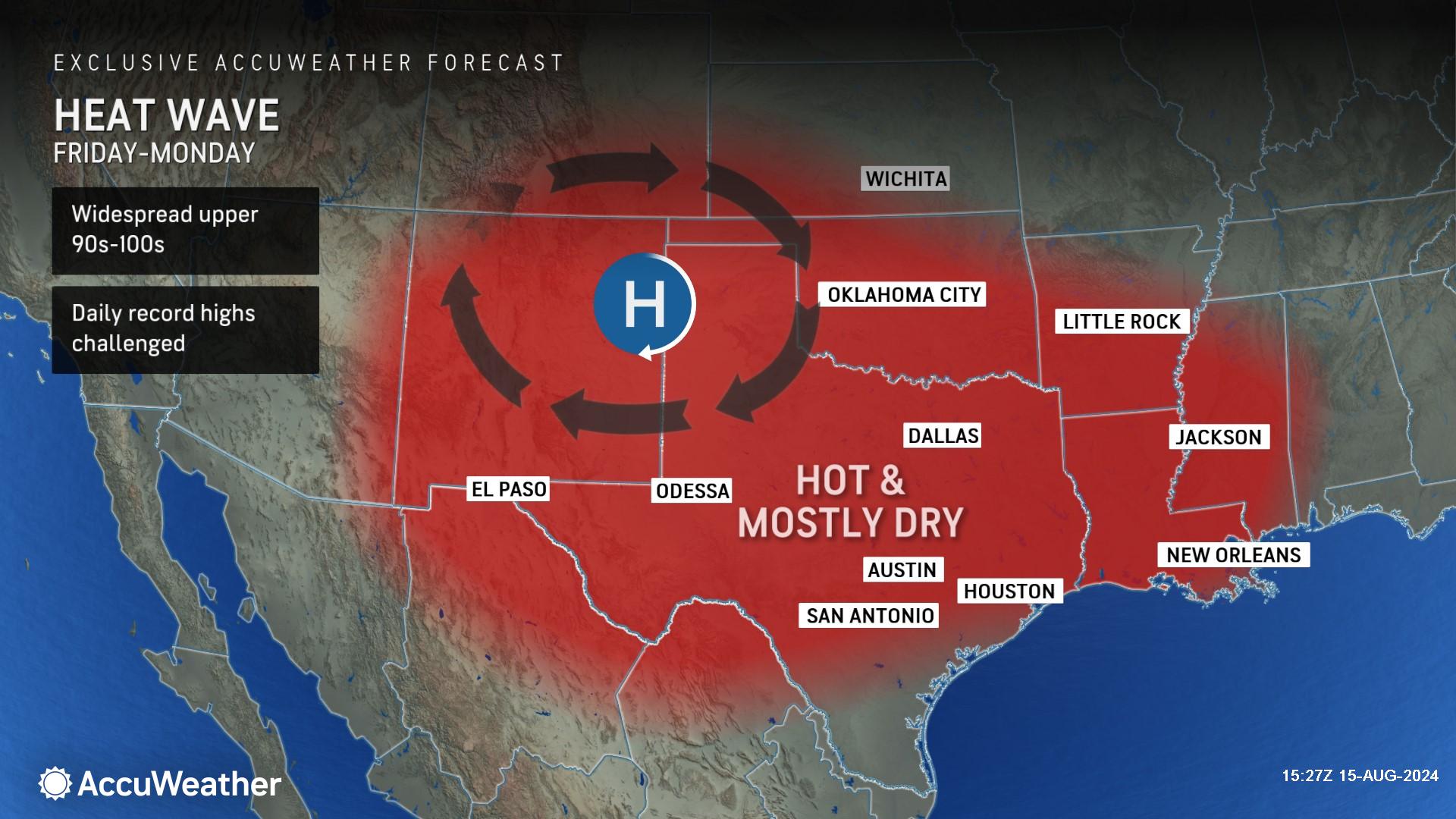
Nearly 9 million people are under Excessive Heat Warnings and another 35 million are under Heat Advisories on Thursday across parts of Florida, Texas, Louisiana, Mississippi, Alabama, Tennessee, Arkansas, Missouri, Oklahoma and Kansas.
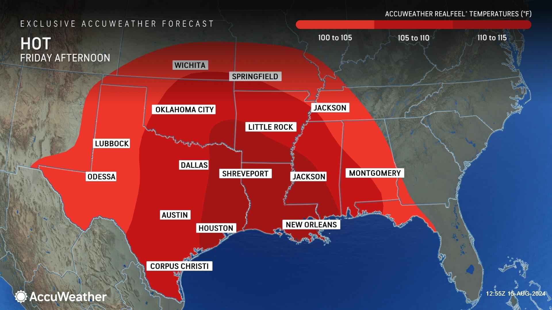
AccuWeather Senior Meteorologist Renee Duff says a heat wave baking parts of the South and Gulf Coast states will challenge daily record high temperatures through the weekend. AccuWeather RealFeel® Temperatures will hover between 105-110 degrees in Houston, Texas, to Shreveport, Louisiana, as well as New Orleans, Louisiana and Jackson, Mississippi on Friday. Communities in this region could experience AccuWeather RealFeel® Temperatures between 110-115 degrees on Friday.
“While the Northeast is experiencing a pause in the summer heat, all indications point toward the South Central states continuing to swelter. The heat is expected to stick around into the last week of August as an area of high pressure holds firm across the region,” said Duff. “We expect to see high temperatures spike 5-10 degrees above the historical average in the coming days across much of the South and Gulf coast states.”
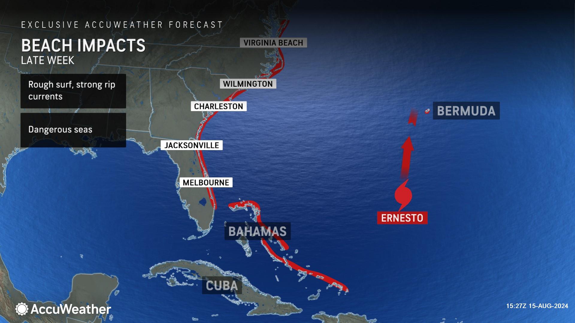
AccuWeather Lead Hurricane Expert Alex DaSilva is warning people heading to beaches along the Atlantic coast looking for relief from the heat to be prepared for rough surf and rip currents from Hurricane Ernesto, which is forecast to remain hundreds of miles away from the coastline of the Southeast and mid-Atlantic coastline.
“These storms can produce big-time waves that propagate out from the storm. There is a little bit of a delay in how fast those waves can arrive at beaches. The rough surf and risk of rip currents should really start ramping up on Friday and Sunday, starting in Florida and expanding north. We could see dangerous rip currents all the way up the East coast through New England,” said DaSilva. “Tragically, we often hear about rescues and even drownings in rip currents at beaches when there’s a hurricane hundreds of miles out to sea. Those dangerous rip currents can still occur on a beautiful sunny day. People go to the beach, they may not think of the hazards, and unfortunately, they can quickly end up in trouble. We always urge people to swim at beaches with lifeguards on duty, especially when there’s a strengthening hurricane just a few hundred miles offshore.”
When will summer heat return to the Northeast?
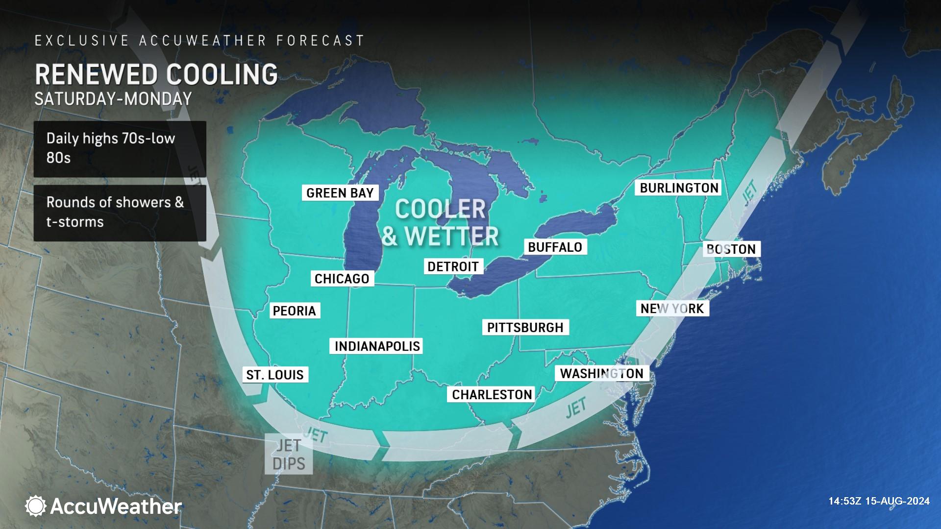
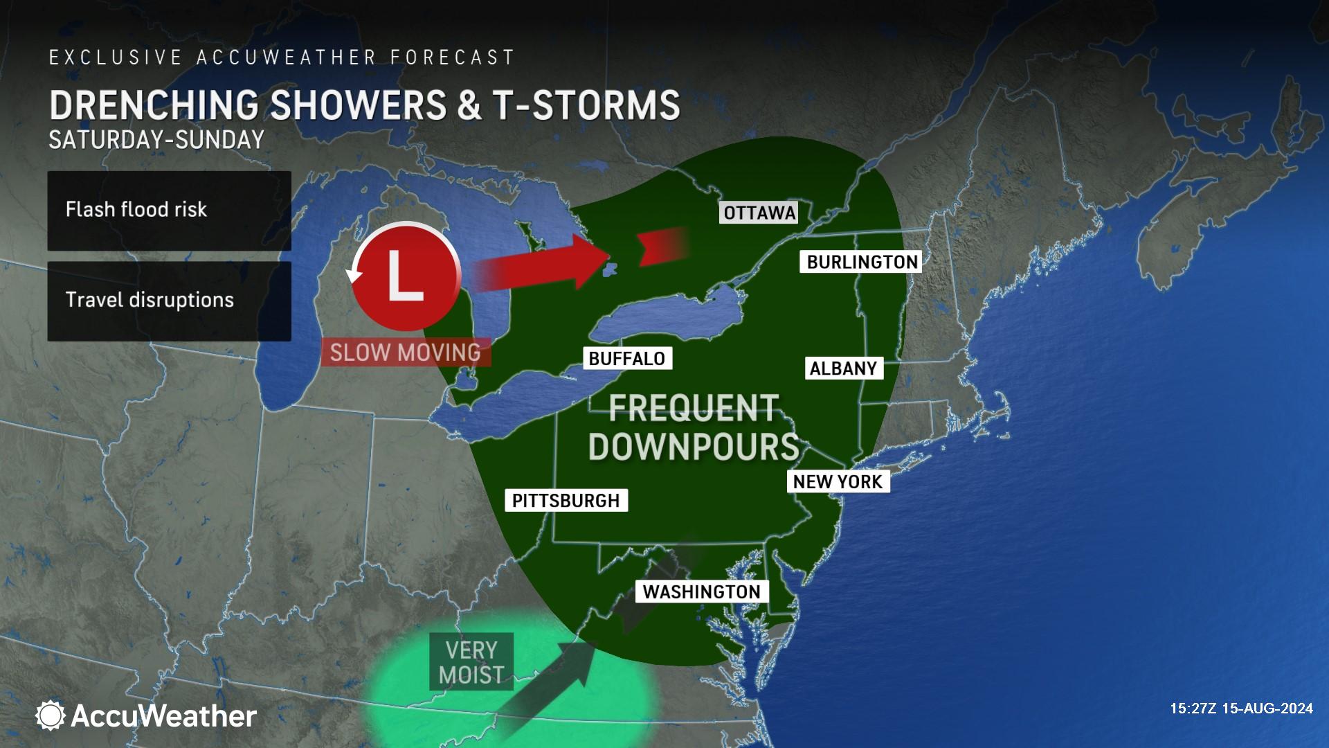
AccuWeather Lead Long-Range Expert Paul Pastelok says much cooler and less humid air swept across the Northeast this past weekend in the wake of Tropical Rainstorm Debby.
"A southward dip in the jet stream will persist from the Midwest to the Northeast for the next one to two weeks," explained Pastelok. "There can be brief warmups and surges of humidity, but that is usually just ahead of a new push of cool air that will soon overtake the region.”
Pastelok said the jet stream configuration that tends to lock out hot air from building northward, and other weather factors, are allowing this cooler summer pattern to linger.
"We don't have the intense sun angle that was present from late June through July and the start of August," said Pastelok."We also have a wet ground now, and what sun's energy is out there is being used up evaporating the moisture from the ground instead of heating up the environment."
Mid-August is typically the time of the year when daily historical average temperatures start to tick downward every few days as the nights gradually lengthen and the period of daytime heating slowly shrinks. This season shift makes it more challenging for long-duration extreme heat.
Pastelok said when a long-lasting jet stream dip develops in the region, like the setup impact in the Northeast right now, it can easily result in temperatures no higher than the historical average and occasionally below the historical average.
"There is an excellent chance this same jet stream setup with its cool conditions will last up to the last week of August," said Pastelok. "We are expecting a typhoon to curve away from eastern Asia in a couple of days, and that translates to cool weather in the Northeast from six to 10 days later."
Temperatures during the month of July were 2-4 degrees above the historical average across much of the Northeast, making the current pattern feel even cooler.
For the middle of August, high temperatures typically range from the mid-70s in northern Maine to the upper 80s around the Chesapeake Bay. Nighttime lows generally range from the mid-50s in northern Maine to the low 70s in the major Interstate 95 cities and coastal shore communities of the mid-Atlantic region and coastal shore communities. These highs and lows are already down a few degrees from the mid-July historical averages.
The pattern can bring periods when high and low temperatures can dip 5-10 degrees below the historical average, especially across the interior Northeast. Rounds of rain and storms can lower temperatures even more.
It may feel a bit warmer near the Atlantic Seaboard, in part due to more humidity. Pastelok said there will still be some frequent intrusions of cooler and less humid air to the coast into late August.
The same pattern will create a slight window for a low-grade tropical feature to form near the Atlantic coast due to the warm waters of the Gulf Stream. However, prevailing west to northwest winds would tend to steer any feature out to sea. Only if the jet stream were to bend around enough might there be room for such a system to approach the U.S. coast.
This sort of setup may be enough to allow Ernesto to approach Newfoundland or perhaps Nova Scotia early next week.
In order for a system, such as Ernesto, to back into the mid-Atlantic region, Pastelok said the jet stream dip would have to back westward toward the Midwest, rather than the Northeast.
"Toward the end of the month, the jet stream pattern may flatten out across the U.S. and that should allow less intrusions of cool air into the Northeast from central Canada," said Pastelok. "In turn, some warmer air from the Plains should be able to mix eastward."
AccuWeather’s team of long-range experts accurately predicted above historical average temperatures across much of the country in July.
Hazards at Atlantic coast beaches from Florida through Maine
AccuWeather expert meteorologists say Ernesto will create rough surf and dangerous rip currents along East coast beaches.
Hazardous beach conditions are expected in Florida starting Thursday. The risk of rip currents and rough surf will expand north throughout the week, eventually impacting beaches in New England by this weekend.
“Do not let your guard down if you’re heading to Atlantic coast beaches later this week or this weekend. The swells from Ernesto could create dangerous rip currents that can be hard to see,” said AccuWeather Lead Hurricane Expert Alex DaSilva. “Ernesto will be hundreds of miles off the U.S. coast. The skies may be blue and the weather may look calm, but the waters could be dangerous. Please stay in areas where lifeguards are on duty, and make sure your family knows about the warning signs and how to escape a rip current by swimming parallel to the coast.”
AccuWeather Forecast Graphics
Additional AccuWeather Resources:
When might summer weather return to the northeastern US?
American cities are getting unbearably hot. These ones are roasting the most
Ernesto to become a major hurricane, threaten Bermuda, Canada
Hurricane Tracking & Storm Radar
How to avoid the potentially deadly grip of a rip current
AccuWeather Forecasts Explosive 2024 Hurricane Season
Rapidly Intensifying Hurricanes Near Coastline Pose Major Threat To U.S. This Season


