


AccuWeather meteorologists are available 24/7 to provide further insights and updates on evolving weather conditions. Please contact pr@accuweather.com during regular business hours, or support@accuweather.com or call AccuWeather’s Media Hotline at (814)-235-8710 at any time to arrange interviews with AccuWeather experts or to request the most updated graphics for print or broadcast.
Potential tropical activity could increase wildfire risks in Hawaii
August 16, 2024

People across Hawaii are being warned of a possible increase in trade winds, which could raise the risk of wildfires sparking or spreading on the islands in the coming
weeks.
AccuWeather Global Weather Center – August 16, 2024
AccuWeather expert meteorologists are tracking several potential tropical threats that could evolve into tropical storms and potentially track toward Hawaii’s general direction in the coming days.
"Aside from the potential impacts from rain and seas, increasing trade winds in lieu of a close encounter could raise the wildfire risk," said AccuWeather Meteorologist Grady Gilman.
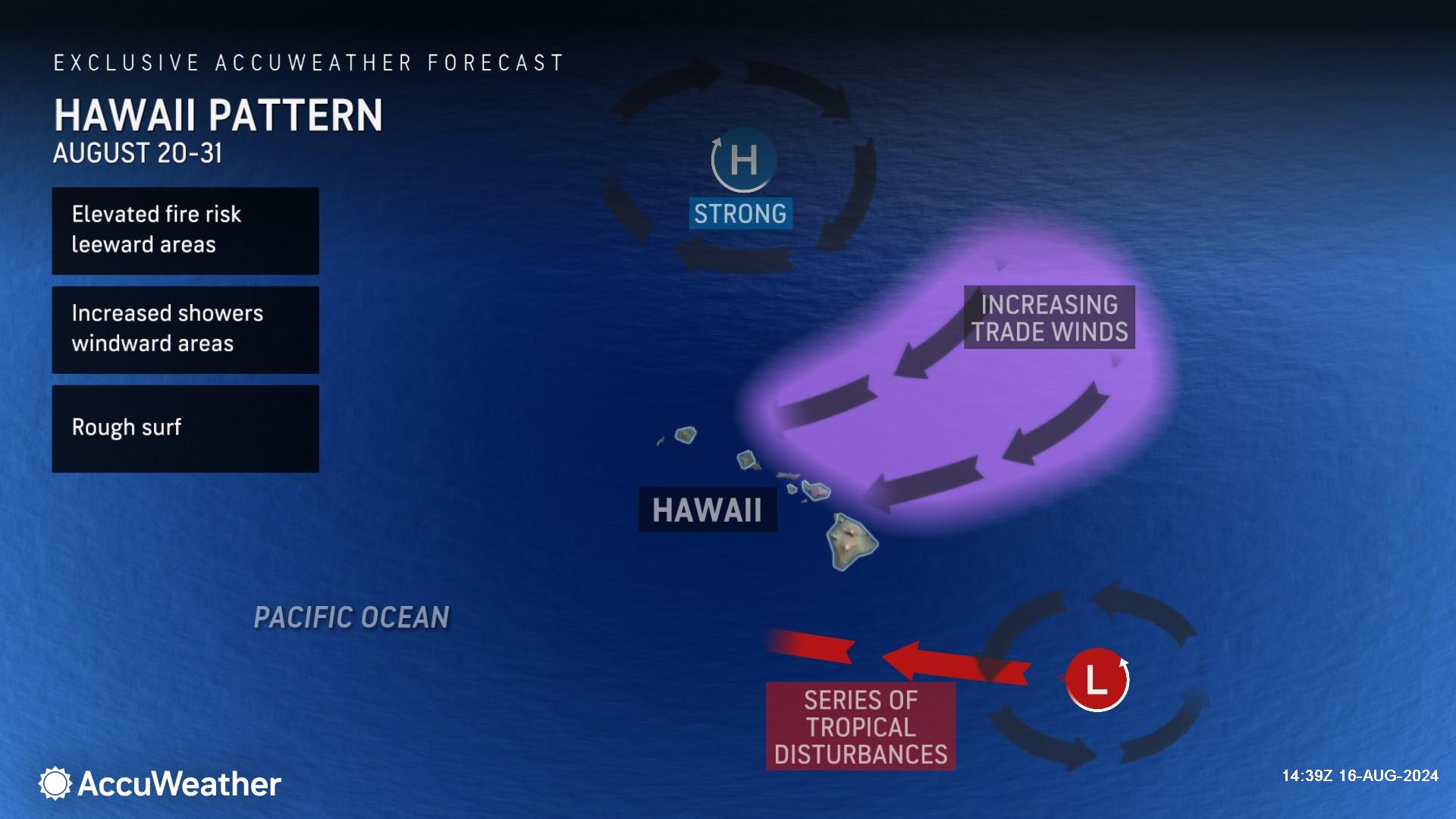
The first area of potential tropical concern is located roughly 1,000 miles to the east-southeast of Hilo, Hawaii. AccuWeather expert meteorologists say it has a medium chance of developing into a tropical depression or storm as it passes well to the south of the islands early next week.
Farther out over the eastern Pacific Ocean, there are two tropical waves of low pressure that AccuWeather meteorologists are closely monitoring. Should they develop and survive, one or both could wander relatively close to the islands later in August. At least one of the two systems has a high chance of developing.
History of wind and wildfires on the islands
Category 4 Hurricane Dora passed well to the south of the islands last August. Even though the powerful core of the hurricane remained far away from the islands, there was a significant difference in atmospheric pressure between the hurricane and strong high pressure over the north-central Pacific. The two factors increased the northeast trade winds on the islands.
Winds became so strong that they downed trees and power lines, which sparked rapidly spreading wildfires, eventually becoming Hawaii's greatest natural disaster.
The most devastating fire occurred on the island of Maui, where more than 100 people were killed and at least 2,200 buildings were destroyed.
AccuWeather Senior Meteorologist Brett Anderson says the setup for next week is similar, but far less intense than in August of 2023.
"The high-pressure area is not nearly as strong as last August, and the system passing by to the south is not the caliber of Hurricane Dora," explained Anderson. "The trade winds should not be as enhanced with the first system passing by as with Dora in 2023."
The two tropical waves of low pressure are a long way off, and much may happen with them in the coming days.
"It is possible that at least one of the two eastern Pacific systems may get close enough to Hawaii late in the month to bring more direct impacts," said AccuWeather Senior Meteorologist Adam Douty.
Impacts could range from an uptick in seas and trade winds around the islands to perhaps strong winds and some heavier rain. Any increase in trade winds in areas where brush and vegetation are dry due to drought would raise the risk of wildfires.
Current soil conditions vary greatly, according to the United States Drought Monitor. There was no drought on the northernmost part of the Big Island, but pockets of severe to extreme drought exist throughout the islands.
AccuWeather Chief Meteorologist Jon Porter is urging residents, tourists, workers, and officials on the island to use caution and closely monitor AccuWeather forecast updates in the coming days.
“While this setup does not appear to be as intense as the unusual setup of August 2023, we want to raise awareness for people, businesses, and government officials that the trade winds can increase at times over the coming weeks,” said Porter. “Given the pockets of severe to extreme drought in parts of the islands, it may result in a localized significant increase in wildfire risk. People should be especially careful with open flames or when conducting other activities that can result in sparks.”
Additional AccuWeather Resources:


