


AccuWeather meteorologists are available 24/7 to provide further insights and updates on evolving weather conditions. Please contact pr@accuweather.com during regular business hours, or support@accuweather.com or call AccuWeather’s Media Hotline at (814)-235-8710 at any time to arrange interviews with AccuWeather experts or to request the most updated graphics for print or broadcast.
Risk of more storms in the Northeast following historic and dangerous flash flooding in Connecticut and Long Island
August 19, 2024

> Six to 10 inches of rainfall Sunday, some falling at 3.5 inches per hour, sparked
dangerous flash flooding in parts of Connecticut, New York and New Jersey
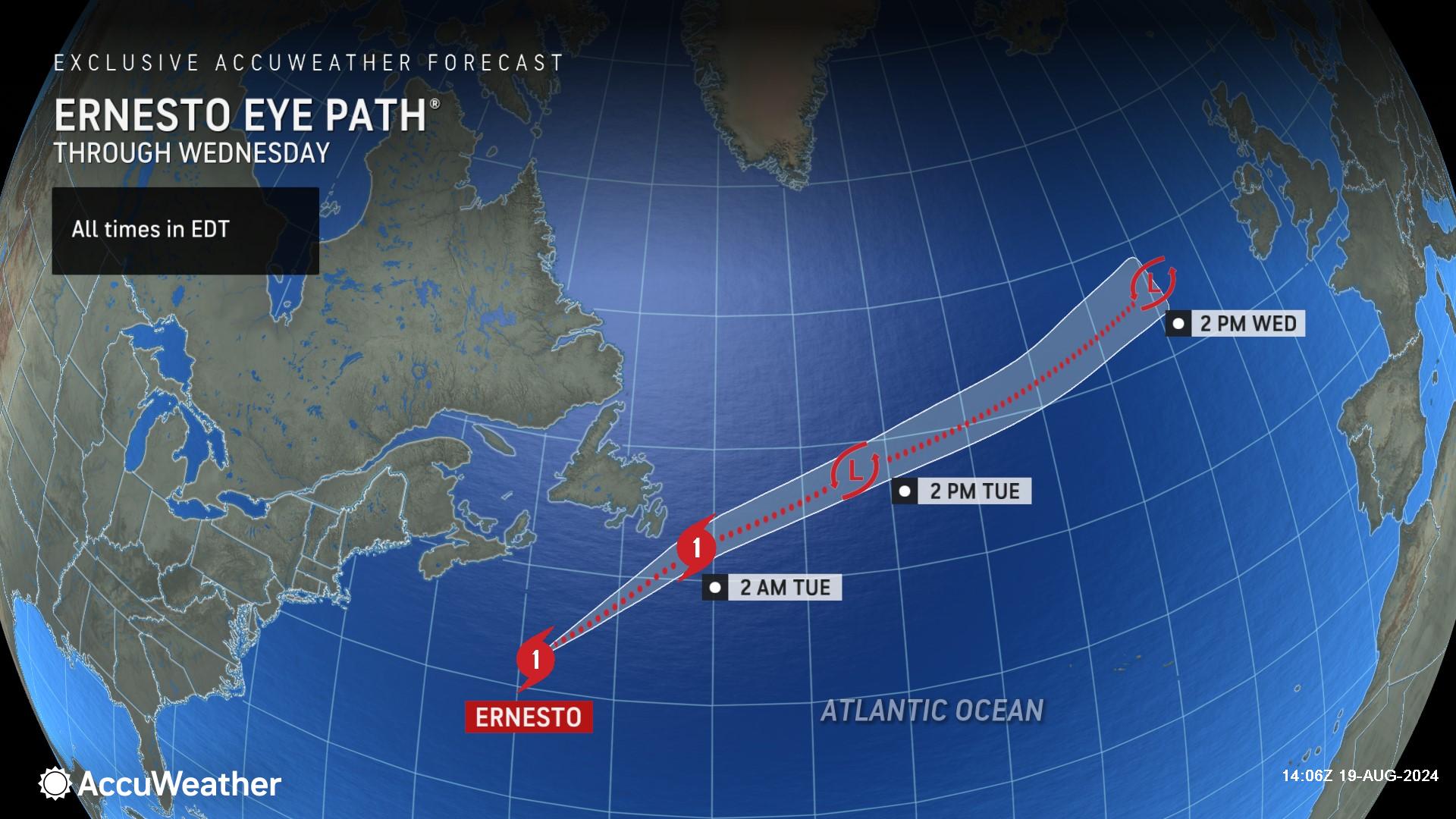
> AccuWeather expert meteorologists say Ernesto contributed to the slow
movement of the torrential downpours
> There will be a risk of more downpours, flash flooding, and trees toppling over
in gusty winds in parts of the Northeast through Monday night
AccuWeather Global Weather Center – August 19, 2024
AccuWeather expert meteorologists say rounds of storms and slow-moving downpours through Monday night could trigger more flash flooding in areas hit hard over the past 24 hours.
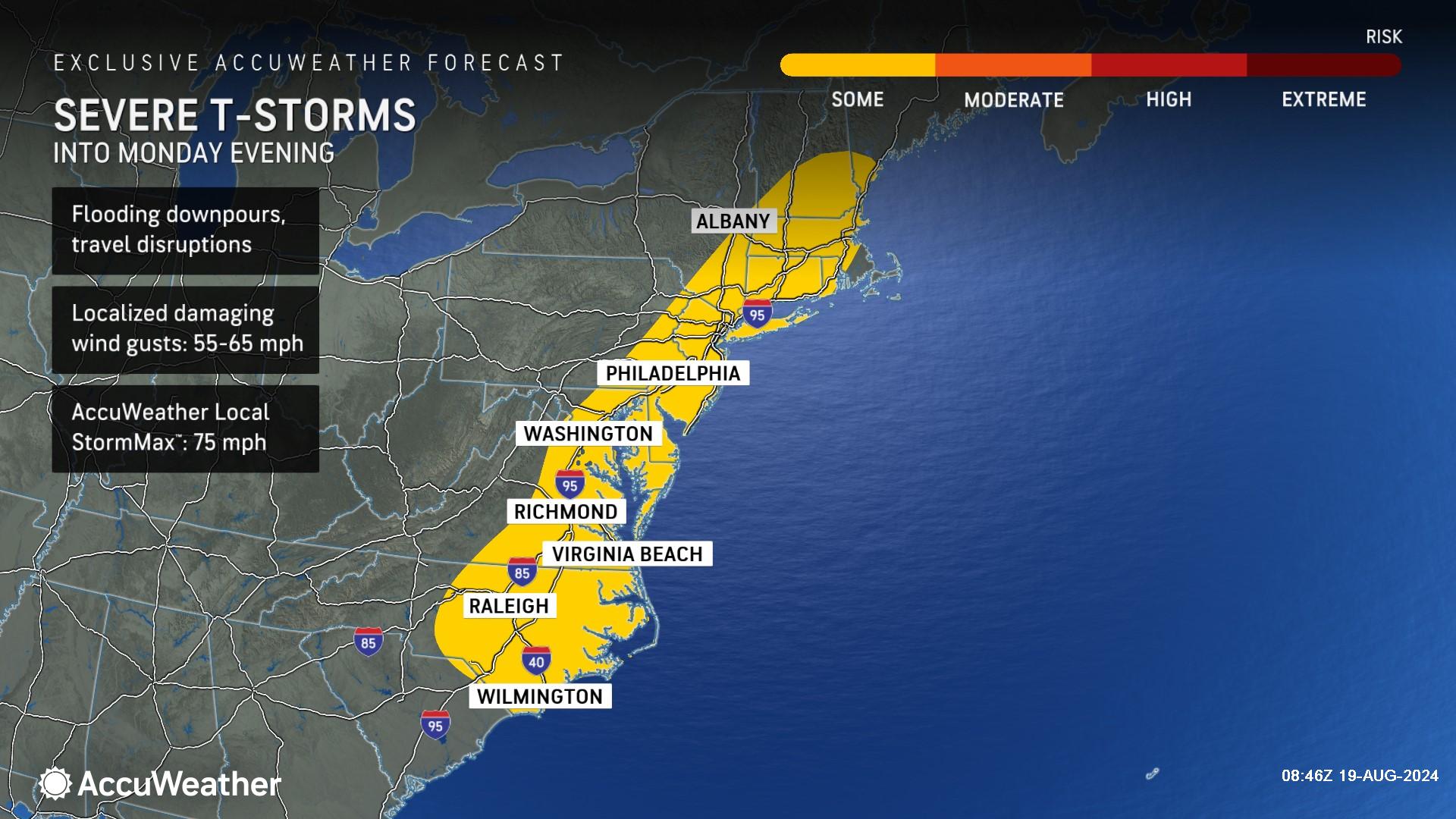
AccuWeather Chief On-Air Meteorologist Bernie Rayno says metro areas like New York City; Hartford, Connecticut;Philadelphia; Washington, D.C.; Richmond, Virginia; and Raleigh, North Carolina, will be within the corridor where potent storms can fire into Monday evening. There will also be some pockets of severe thunderstorms and flooding downpours in central and eastern New England, including Boston; Providence, Rhode Island; and Portland, Maine. Localized wind gusts of 55-65 mph are possible with an AccuWeather Local StormMax™ of 75 mph.
“Storms are expected in New York City during the afternoon commute. Parts of Connecticut, New York and Long Island can see another inch or two of rain,” said Rayno. “It’s not nearly as much rainfall as we saw over the weekend, but the ground is very saturated. Any additional thunderstorms could cause more flooding. Tree roots could be compromised from all of the recent rain. Any gusty winds could bring down trees and power lines.”
Areas that sustained infrastructure damage to drainage systems and roadways during Debby’s deluge and downpours this past weekend may be most vulnerable to the quick runoff from downpours into Monday evening.
What caused the destructive flooding in the Northeast?
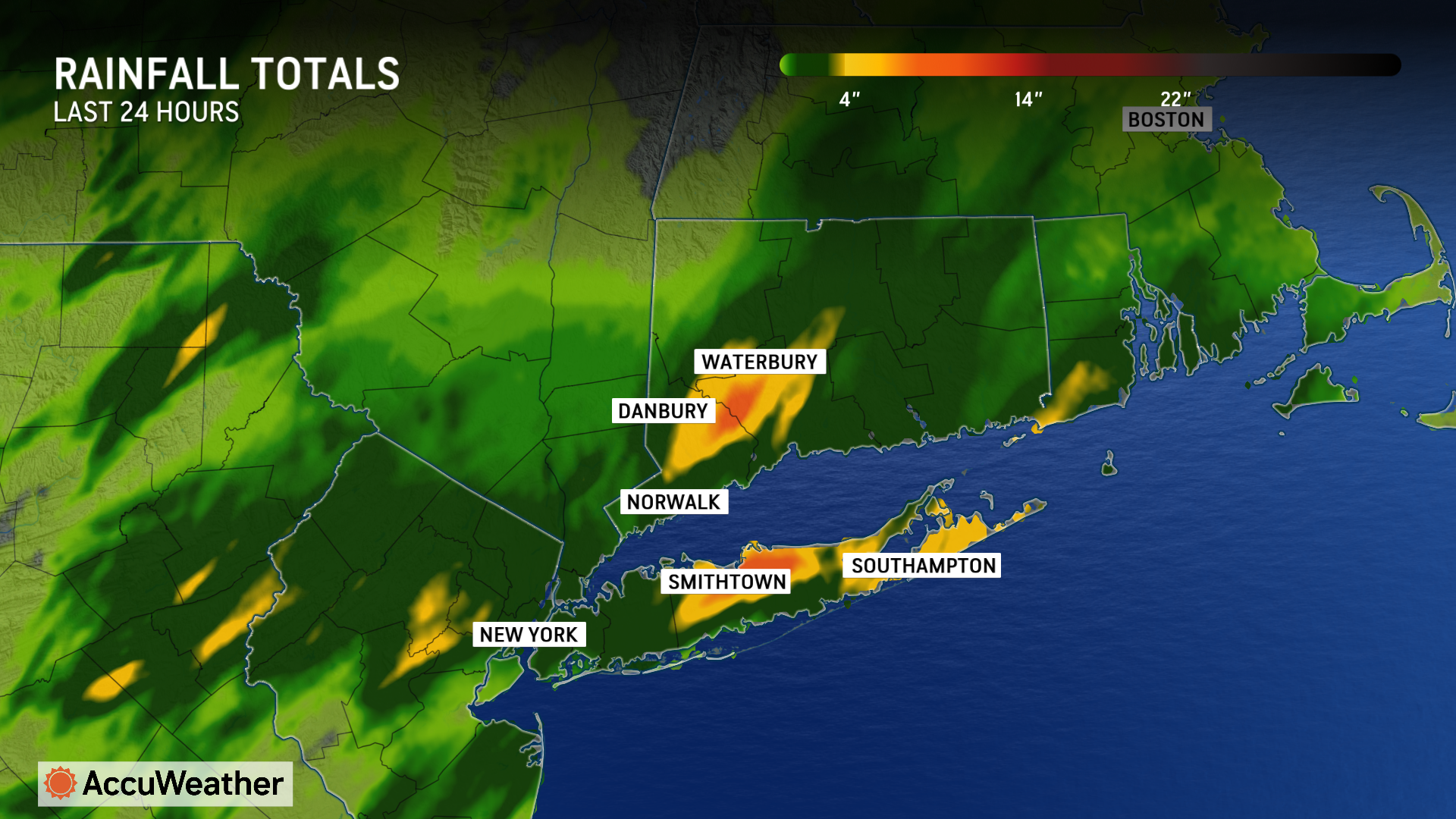
Slow-moving downpours and thunderstorms dumped nearly a foot of rain in parts of Connecticut, New York and New Jersey Sunday and early Monday morning.
Although Ernesto’s moisture did not cause the flooding, Rayno said Ernesto indirectly contributed to the slow movement of the storms. More than 10 inches of rain fell in parts of Connecticut and more than 9 inches of rainfall was reported in parts of New York.
“There were three epicenters of heavy rainfall and flooding. Northern New Jersey, southwestern Connecticut and parts of Long Island. Ernesto created a meteorological traffic jam,” explained Rayno. “The dip in the jet stream over the Northeast would typically take 24 hours to clear the East Coast. This one is going to take about three days.”
AccuWeather Chief Meteorologist Jon Porter said that the “meteorological traffic jam” also contributed to slow progression of thunderstorms along the Eastern Seaboard in recent days and enabled downpours to linger over the same areas for multiple hours on end, a contributor to the seriousness of the flash flooding.
“Another factor in producing such high rainfall rates was the direct feed of tropical moisture being funneled into the Eastern Seaboard, originating from the Gulf of Mexico where water temperatures are averaging 4 to 8 degrees above historical averages, which encourages higher levels of moisture being drawn into the atmosphere and directed northward,” said Porter.
The warming atmosphere and impacts from climate change are also contributing to higher rainfall rates.
"The odds of extreme rainfall events with rainfall rates greater than 3 or 4 inches per hour are increasing, and it’s being driven by climate change,” said Porter. “We expect to see more flash flooding like this in the future. Families and businesses need to be prepared, especially in valleys and other flood prone areas.”
Porter said relentless rainfall rates led to dangerous flash flooding, which resulted in vehicles being swept away and multiple rescues.
“Time after time in extreme rainfall, AccuWeather expert meteorologists highlight that even more important than the total amount of rainfall that occurs is how fast the rain is falling. During this cloudburst, rain was coming down at times at a rate of more than 3.5 inches per hour at times. The rainfall totals observed over three or six hours in this part of the country might happen statistically once every 1,000 years in the climate, or said another way, have a 0.1% chance of happening in these areas in a given year. We just had two of these flooding events within the span of 12 hours just 35 miles apart,” said Porter. “Those rainfall rates above 3 inches per hour are too fast and too furious for drainage systems and creeks to handle.”
Porter, who grew up in Connecticut, said the “catastrophic damage” from this flash flood disaster in parts of southwest Connecticut was particularly notable because parts of Connecticut receiving such high rainfall totals over a short period of time, not associated with a tropical storm or hurricane, is exceedingly rare. Localized, catastrophic flash flooding from tropical storms or hurricanes is part of the climatology of Connecticut, but there are only a few other known situations not caused by a tropical storm or hurricane in modern times in Connecticut – including a devastating flash flood along the Connecticut shoreline in June 1982.
Porter said people in the region need to be prepared for more heavy rainfall, which could lead to more flooding into Monday evening.
“It’s not over yet. This is a different setup into Monday evening, compared to what occurred over the weekend, and we expect thunderstorms will have less of a risk to move very slowly, which means flooding concerns can be more localized than recent days, but people should be on alert. Take any flash flooding warnings seriously. We’ve already seen a lot of rain in recent days across parts of the Eastern Seaboard. It won’t take much more rain to trigger dangerous flash flooding and exacerbate existing flooding,” said Porter. “Please avoid travel if possible when there’s a flash flood warning issued for your area. Some of the most dangerous situations happen when people underestimate how deep the water is and they try to drive down a flooded road. The video from this flooding disaster once again serves as a reminder of how quickly a flash flooding situation can escalate from being dangerous to becoming a life-threatening emergency in the matter of only a few minutes. Many times, drivers don’t know how deep the water is, how fast it’s moving, or if the roadway underneath has been compromised or already washed out.”
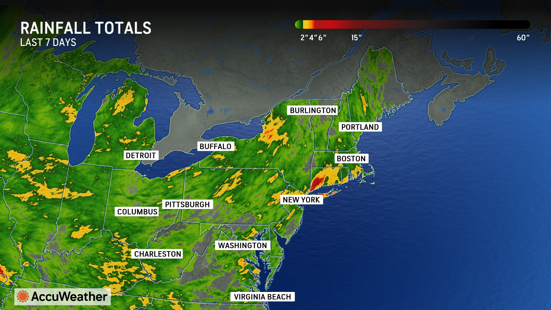
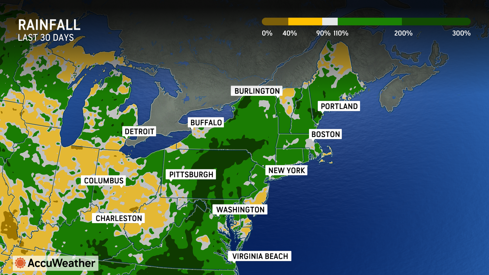
Parts of the Northeast and mid-Atlantic have seen 200 to 300% of rainfall in the past 30 days, compared to the historical average.
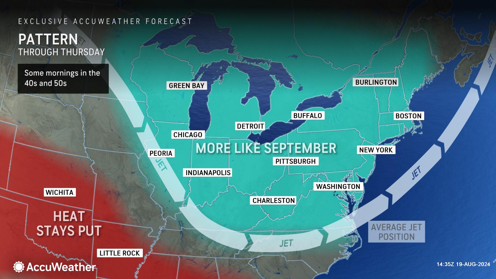
AccuWeather expert meteorologists say the Northeast is in for a pattern change this week with a series of cool intrusions through the region. This can provide temperatures that are below the historical average through Thursday. Along with lower temperatures, many will also be able to enjoy more comfortable and less humid conditions as well as dry weather.
Hazards at Atlantic coast beaches from Florida through Maine
AccuWeather expert meteorologists say Ernesto will create rough surf and dangerous rip currents along East coast beaches.
Hazardous beach conditions are expected in Florida starting Thursday. The risk of rip currents and rough surf will expand north throughout the week, eventually impacting beaches in New England by this weekend.
“Do not let your guard down if you’re heading to Atlantic coast beaches later this week or this weekend. The swells from Ernesto could create dangerous rip currents that can be hard to see,” said AccuWeather Lead Hurricane Expert Alex DaSilva. “Ernesto will be hundreds of miles off the U.S. coast. The skies may be blue and the weather may look calm, but the waters could be dangerous. Please stay in areas where lifeguards are on duty, and make sure your family knows about the warning signs and how to escape a rip current by swimming parallel to the coast.”
AccuWeather Forecast Graphics
Additional AccuWeather Resources:


