


AccuWeather meteorologists are available 24/7 to provide further insights and updates on evolving weather conditions. Please contact pr@accuweather.com during regular business hours, or support@accuweather.com or call AccuWeather’s Media Hotline at (814)-235-8710 at any time to arrange interviews with AccuWeather experts or to request the most updated graphics for print or broadcast.
AccuWeather Forecasting 6 to 10 named storms during Supercharged September
August 22, 2024

> Less wind shear and less dry air will create conducive conditions for
development in the Atlantic Ocean beginning at the end of August
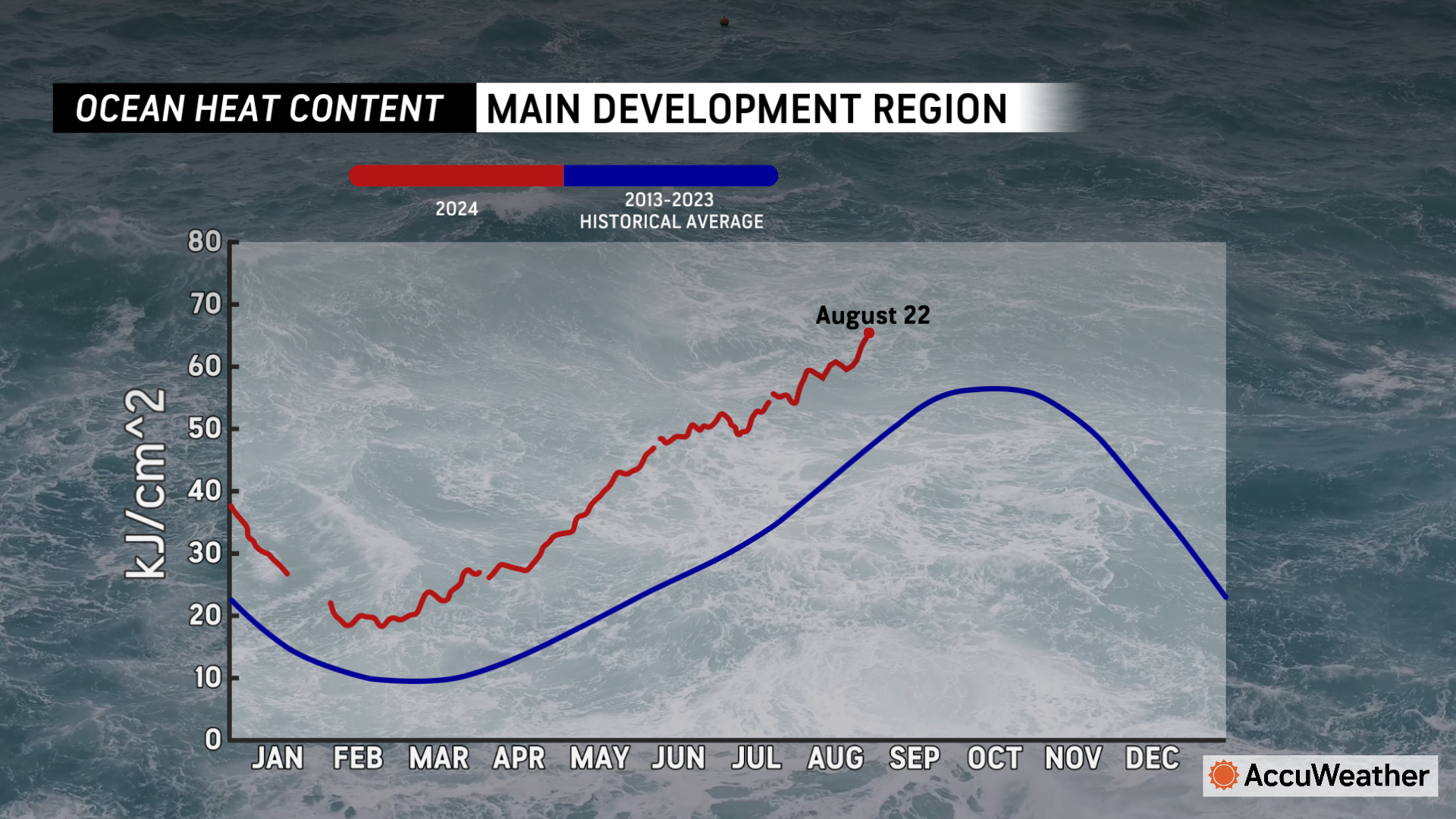
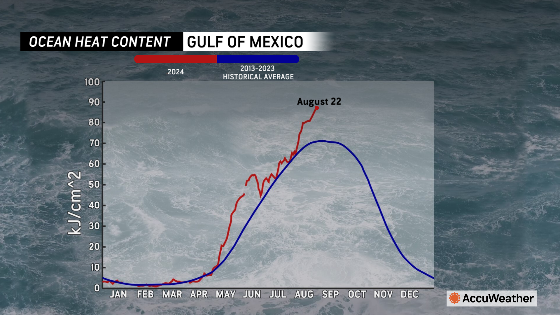
> Water temperatures are near or at record-high levels across much of the
Atlantic, Caribbean and Gulf of Mexico
> Near-record levels of Saharan dust are expected to clear out during the final
week of August
AccuWeather Global Weather Center – August 22, 2024
Following a brief lull in tropical activity in the wake of Hurricane Ernesto, AccuWeather expert meteorologists are warning people to prepare for back-to-back tropical threats in the Atlantic basin in the coming weeks.

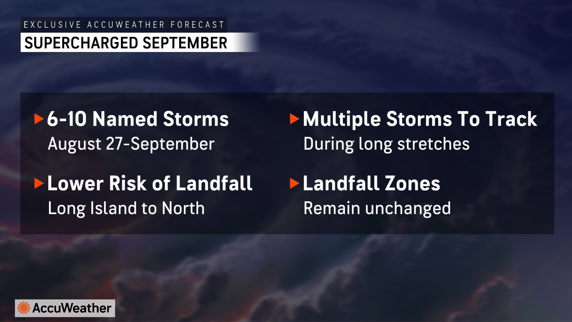
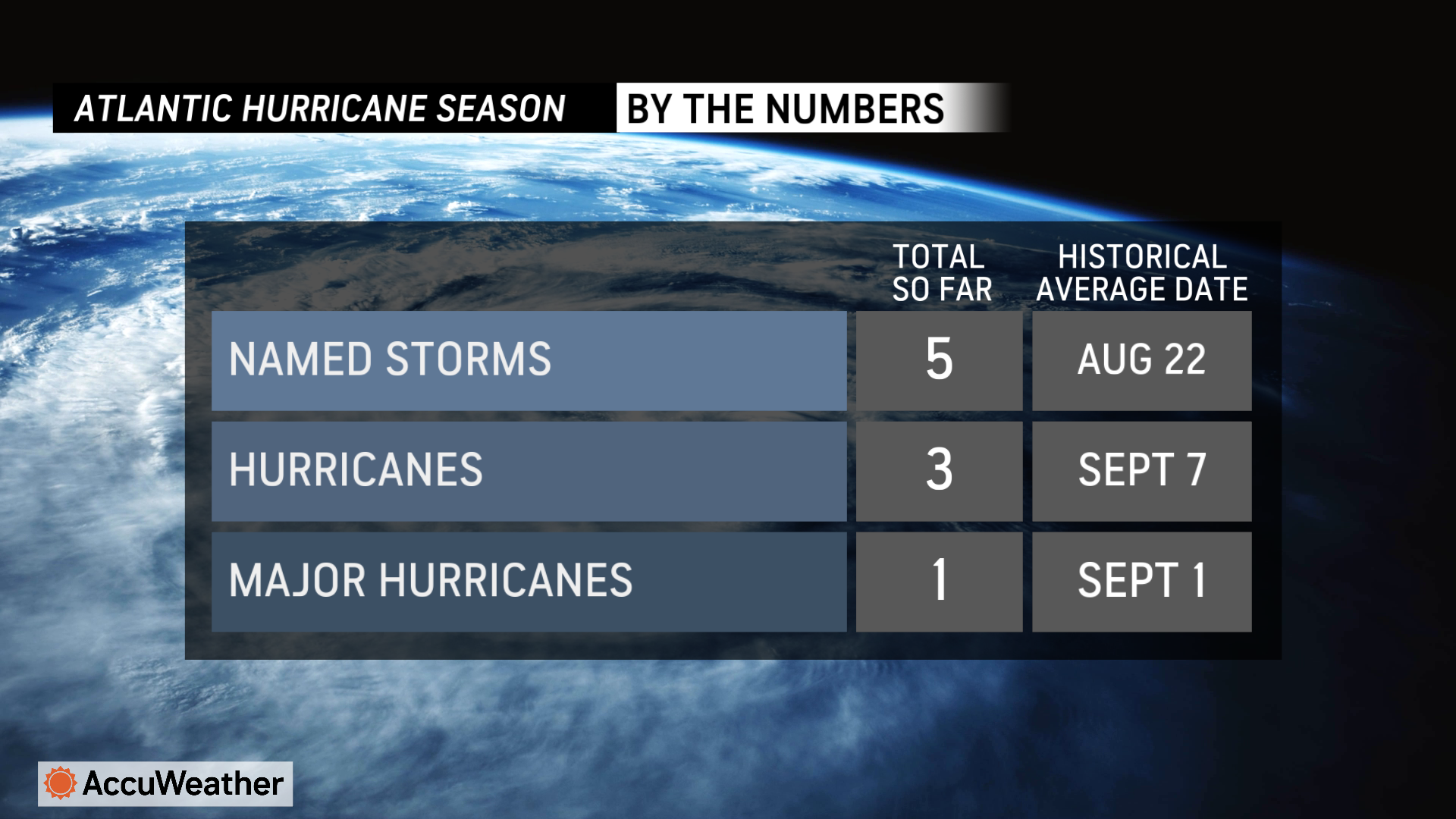
AccuWeather Lead Hurricane Expert Alex DaSilva and the team of AccuWeather expert meteorologists are forecasting 6 to 10 named storms from Aug. 27 through Sept. 30.
The historic average is six named storms during Aug. 27 through Sept. 30.
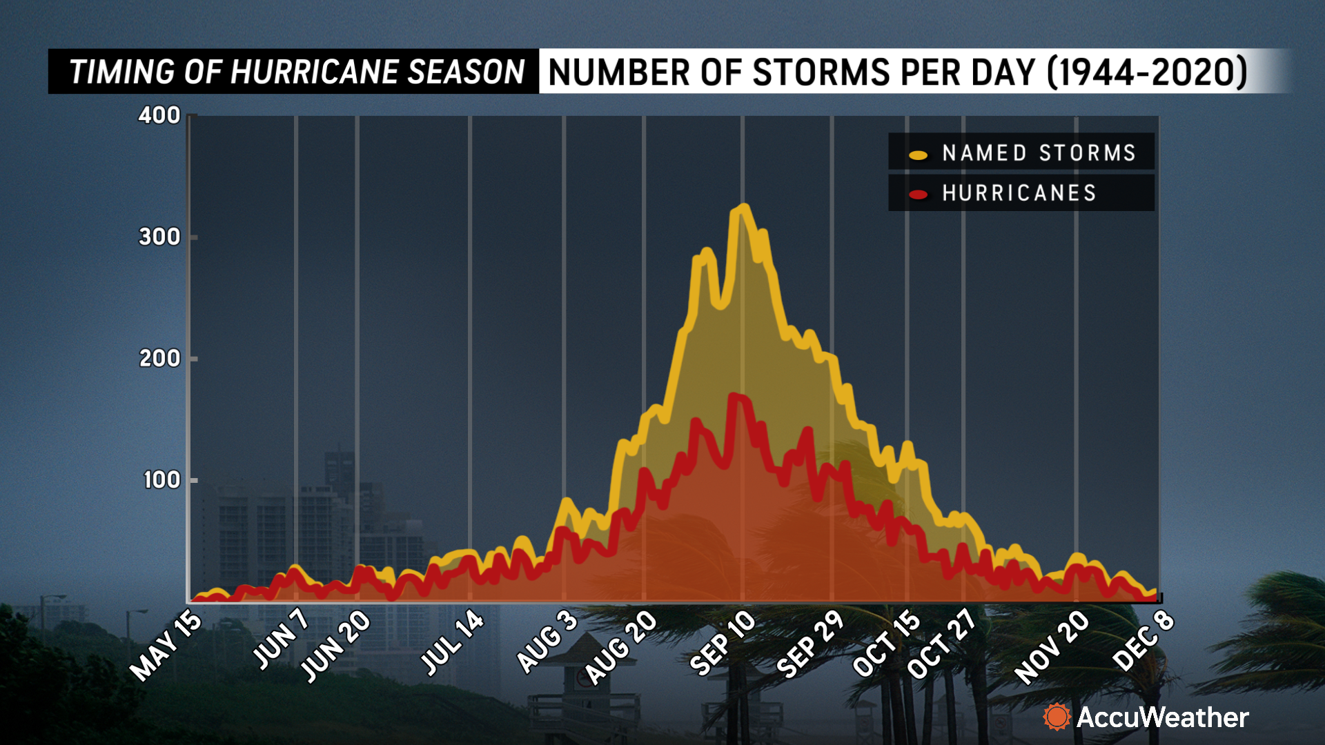
“We could see a parade of storms developing during the month of September. There’s a possibility that we could see multiple tropical storms and hurricanes in the Atlantic basin on the same day, similar to the frequency of storms that we’ve seen during other supercharged hurricane seasons like 2020,” said DaSilva. “The statistical peak of the hurricane season is Sept. 10, and we expect the Atlantic basin to be incredibly active.”
What’s boosting the risk of tropical threats?
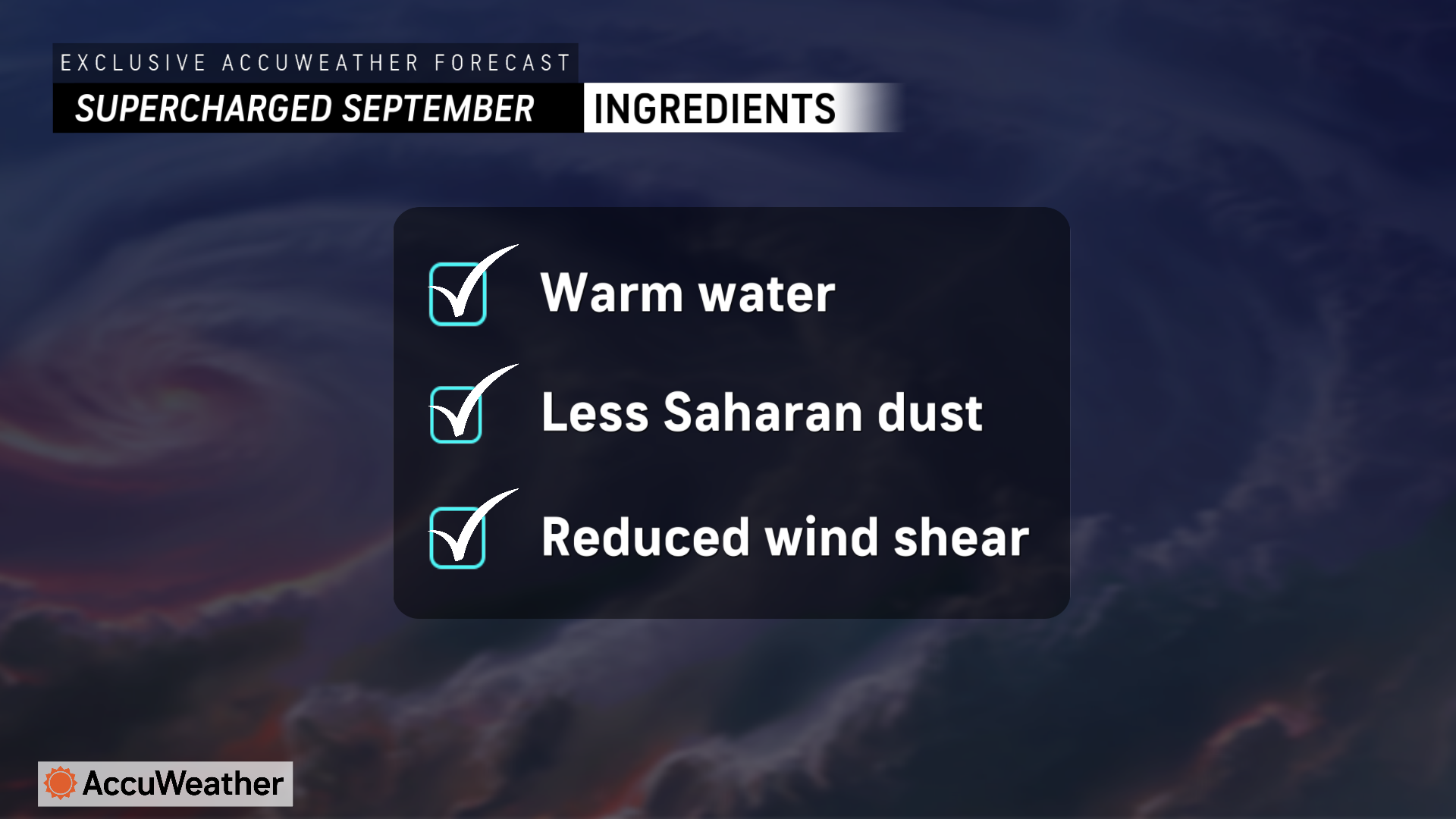
Dry air and Saharan dust across much of the Atlantic basin have limited tropical development in the wake of Hurricane Ernesto, but DaSilva says both inhibiting factors are expected to ease in the final days of August.
“We often see one tropical wave move off the coast of Africa every few days during the peak of the Atlantic hurricane season,” said DaSilva. “With less Saharan dust and dry air expected in the coming weeks, we could see those tropical waves take advantage of very favorable conditions. With extremely warm water temperatures, less disruptive wind shear, and less dry air, we could see a storm organizing every few days.”
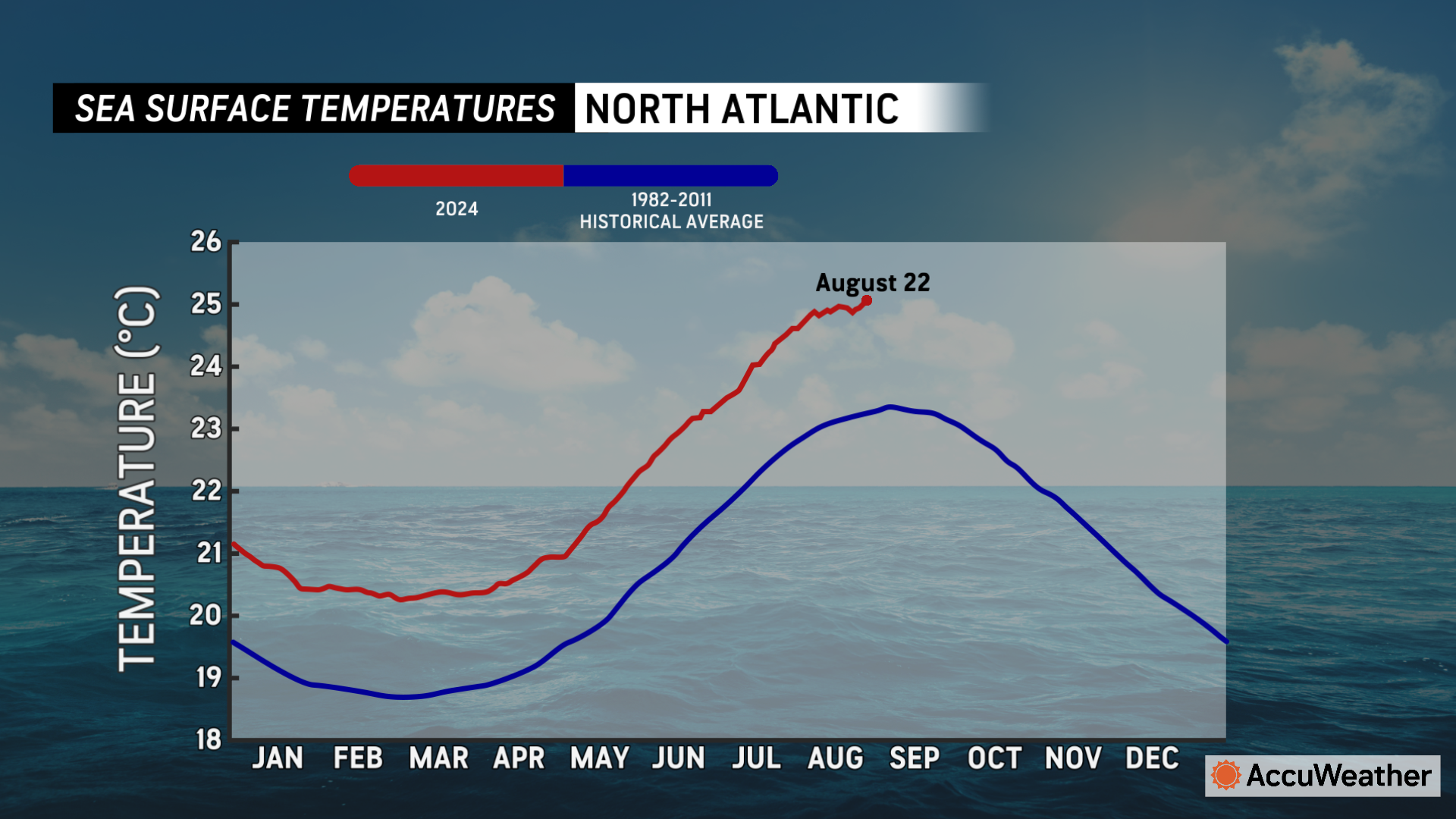
DaSilva says sea surface temperatures and ocean heat content, or the depth that warm waters reach beneath the surface, are near or at record-high levels across much of the Atlantic Ocean and Gulf of Mexico.
Inland flash flood risk
Although hurricanes often make headlines for their landfall with destructive wind gusts, AccuWeather expert meteorologists warn that storms are creating bigger impacts reaching farther inland.
“The inland impacts we’ve already seen from hurricanes this year are vivid reminder that everyone needs to be prepared across much of the eastern United States, even if they live hundreds of miles from the coast,” warned DaSilva. “Hurricane Beryl made landfall along the Texas coast, but that storm spun up dozens of destructive tornadoes as it moved inland from the Gulf Coast all the way to upstate New York, more than 1,400 miles away.”
DaSilva says inland flooding threats from hurricanes and tropical storms can cause billions of dollars in damage.
“Hurricane Debby produced drenching rainfall as it slowly moved across Florida and the Carolinas, flooding thousands of homes and businesses. Even as Debby picked up speed and blasted through the mid-Atlantic and Northeast, it unleashed impressive rainfall that was too much for streams and creeks to keep up with,” said DaSilva. “As AccuWeather accurately forecast ahead of other known sources, destructive flash flooding and water rescues in Pennsylvania and New York, all caused by a hurricane that made landfall in Florida. When all was said and done, AccuWeather estimated that Debby caused $28 billion in total damage and economic loss.”
AccuWeather Chief Meteorologist Jon Porter says several regions along the East coast could face an elevated risk for flash flooding if another tropical storm or hurricane impacts the area in September.
“Debby caused widespread flooding in Florida and the Carolinas, all the way to Pennsylvania and upstate New York. We’ve also seen drenching rainfall, not directly linked to a tropical storm, cause dangerous flash flooding in Connecticut and Long Island,” said Porter. “Some areas of the mid-Atlantic and Northeast have received 200-300 percent of the historical average rainfall in the past 30 days. The ground is saturated and additional rainfall can quickly runoff, resulting in renewed flooding concerns. Any new tropical threats that bring heavy rainfall to the Carolinas, mid-Atlantic, and Northeast could quickly cause more flash flooding, which is a major concern in September.”
Hazards from storms far out to sea
While some tropical threats that develop in late August and September may not directly reach the United States, DaSilva reminds people that tropical storms and hurricanes that stay hundreds of miles off the coast can create dangerous conditions along the shore.
“Many years, we’ll see at least one named storm stay hundreds of miles offshore, but it still creates dangerous rough surf and deadly rip currents,” said DaSilva. “We want everyone, especially tourists and families visiting beaches, to understand that the weather may look nice at the shore, but a storm hundreds of miles away can create powerful rip currents. We’ve seen too many tragic cases of rip current drownings on sunny days when there’s a storm brewing hundreds of miles out to sea.”
Three rip current fatalities have been reported off the coast of the Carolinas this month.
Climate connection
AccuWeather Senior Meteorologist and Climate Expert Brett Anderson says impacts from climate change and our warming atmosphere are leading to bigger hurricane season impacts that can affect more people.
“With the climate changing, the lower atmosphere is warming, and warmer air is able to hold more moisture compared to cooler air, which can increase the risk for more extreme precipitation rates in a storm or hurricane,” said Anderson. “Sea surface temperatures over the eastern Gulf of Mexico, where Debby saw its greatest increase in strength, continue to run near record high levels. The added amount of heat to these waters clearly provided an additional boost of energy for the storm before it made landfall, allowing it to reach category 1 strength. Dry air on the western side of the storm may have prevented Debby from rapidly strengthening into a Category 2 or higher hurricane.”
Anderson says the risk of rapid intensification and coastal flooding has been increasing in recent decades and is expected to worsen in the future.
“The frequency of coastal flooding along the Gulf and East coasts of the U.S. has greatly increased over the past 60 years, with a notable acceleration since 2010,” said Anderson. “The rate of hurricane intensification has also significantly increased along the U.S. Atlantic coast over the past 40 years, likely due mostly to warming waters. This trend is projected to continue over the coming decades.”
Anderson says families, businesses, and officials along the Atlantic and Gulf coasts need to be prepared for more storm impacts, which could take a bigger financial toll in the years to come.
“As we continue to build more homes, rental homes and condos along the coast, and especially on barrier islands, we will see more damage and more people being displaced, resulting in even higher damage costs. We expect more and more insurers will continue to raise rates for coverage along the coast, or decline coverage in more high-risk and exposed areas,” explained Anderson. “If the demand to live along low-lying coastal areas continues to remain strong, then officials need to develop better strategies and regulations in order to further adapt to climate change and the worsening impacts.”
How many more storms are expected in 2024?
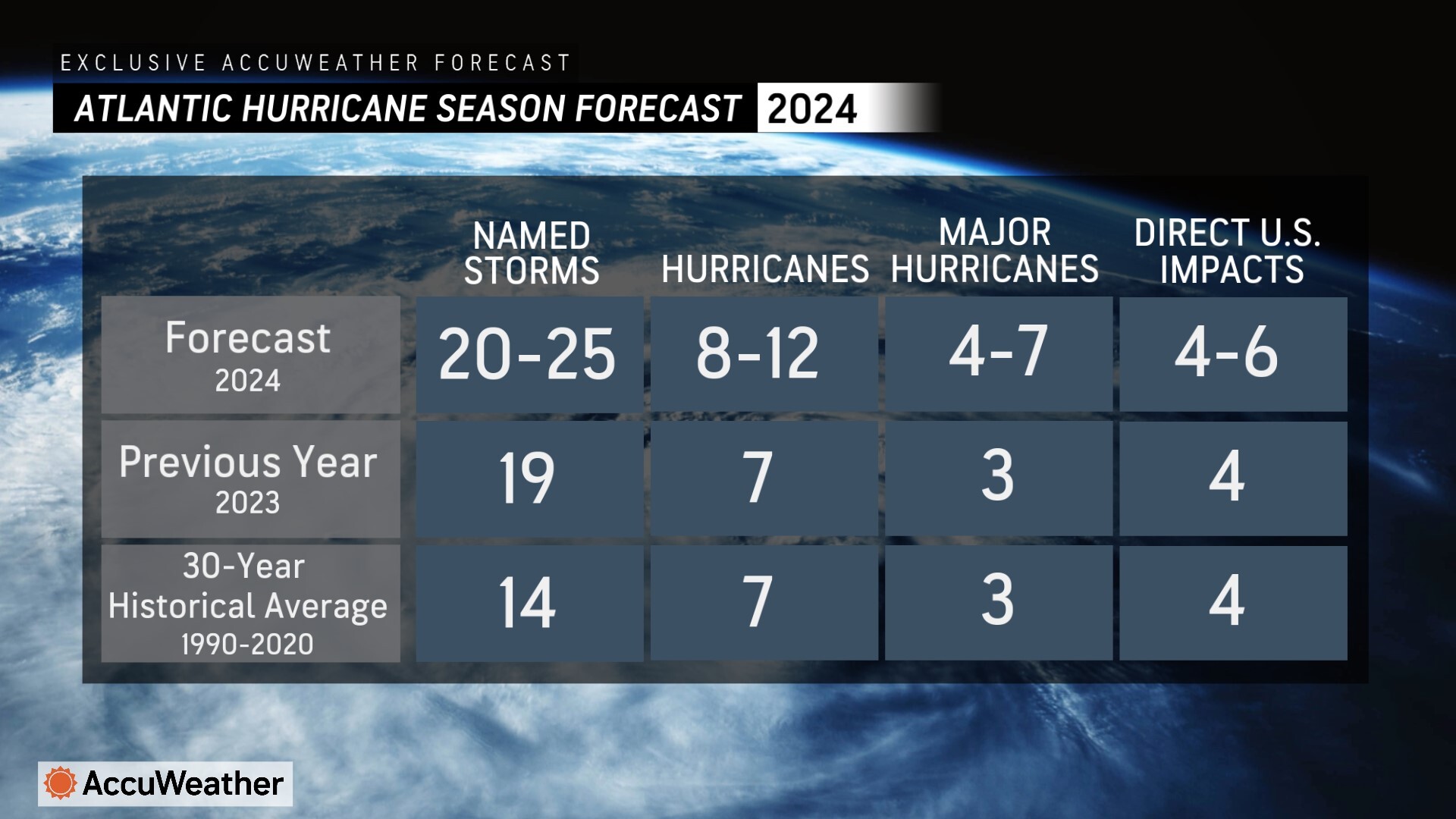
AccuWeather expert meteorologists have been forecasting a total of 20 to 25 named storms and four to six direct impacts on the United States this year.
With extremely warm waters and favorable conditions expected, DaSilva says tropical threats could extend will into November this year. The 2020 hurricane season currently holds the record of 30 named storms in one year.
“If the wind shear holds off and we see more influences from La Niña later this season, we could see one, two, or even three named storms in November,” said DaSilva.
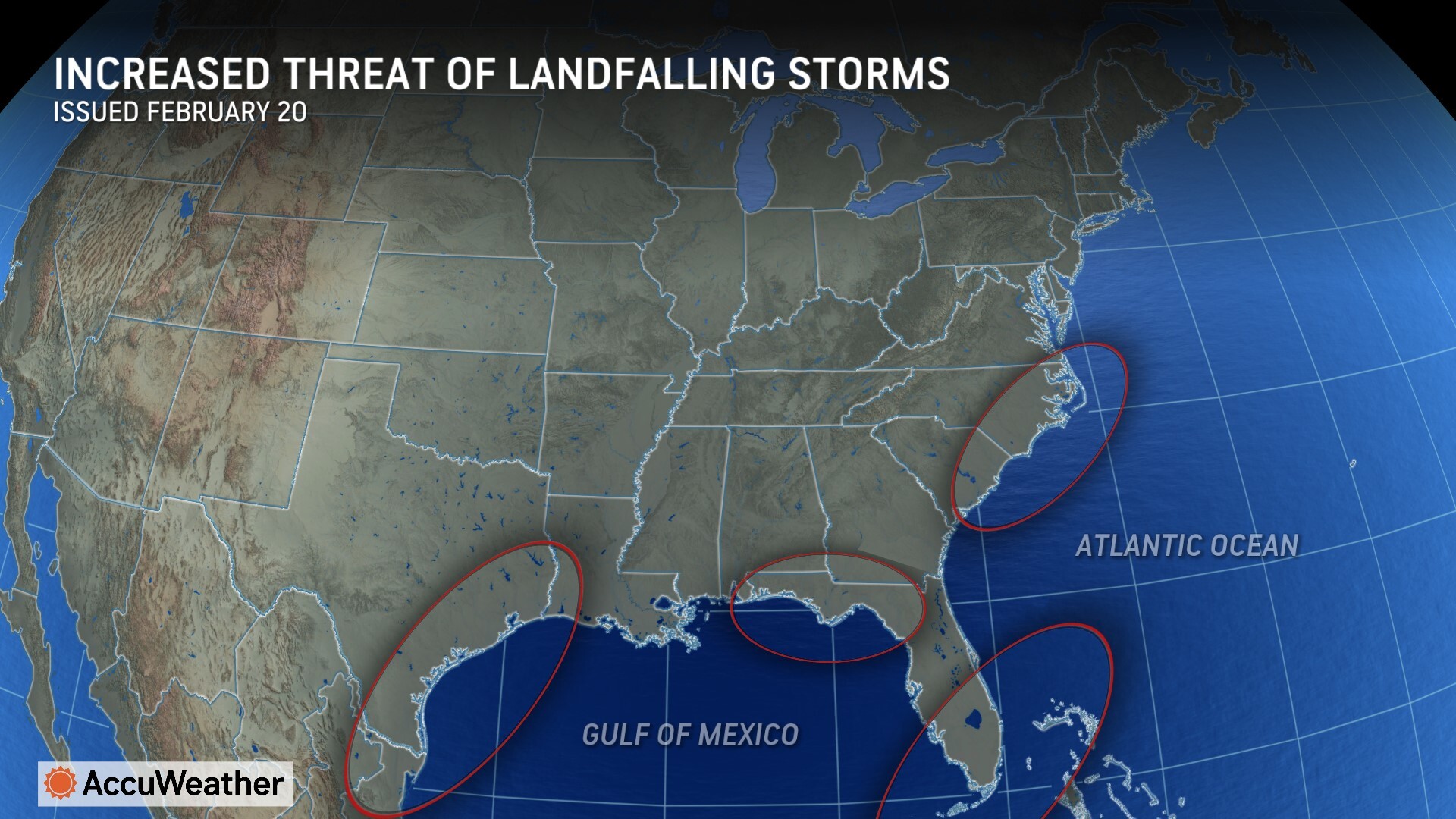
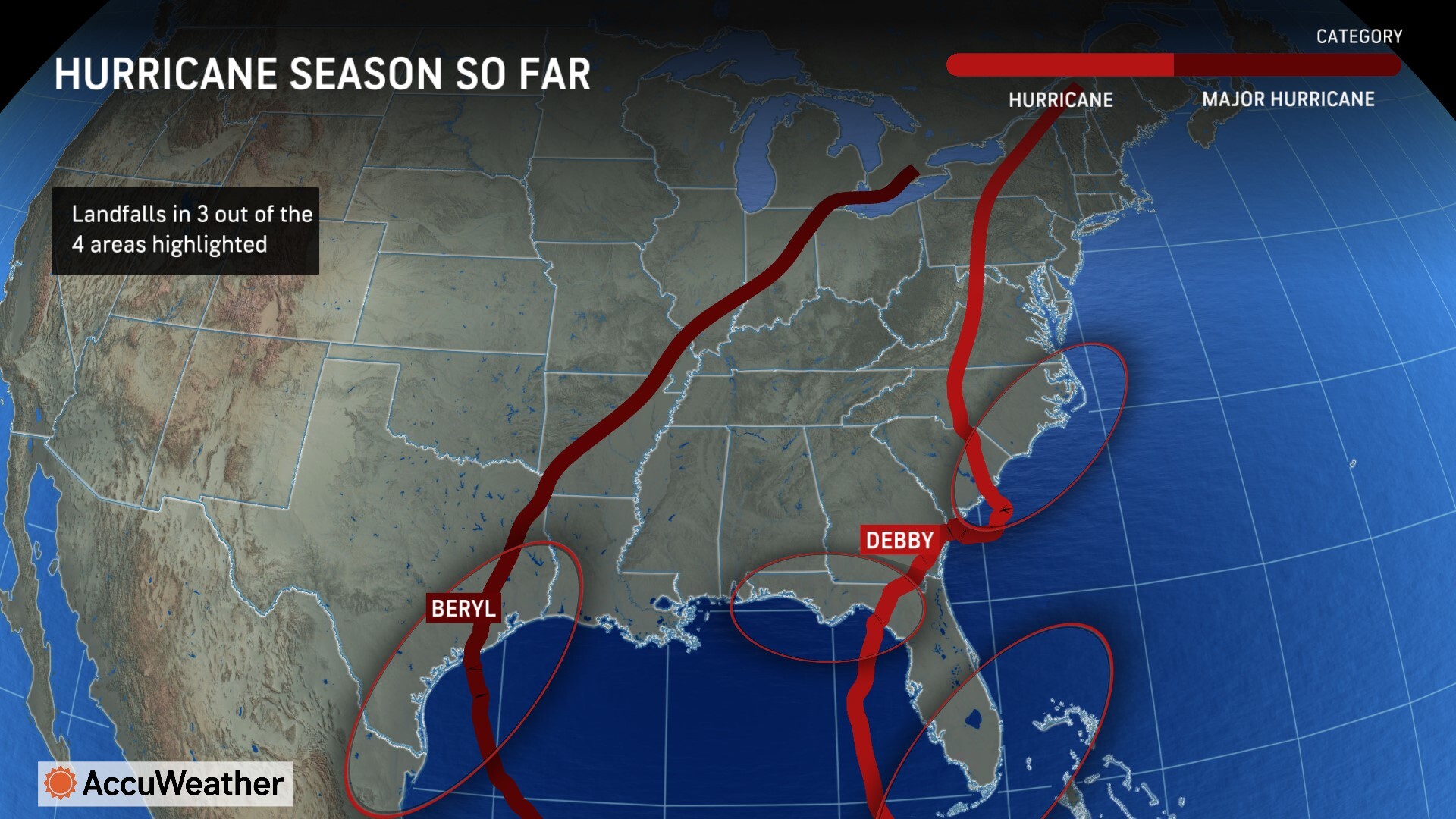
The AccuWeather 2024 U.S. Hurricane Forecast issued in March warned that the Texas coast, Florida Panhandle, South Florida, and the Carolinas faced a higher-than-average risk of direct impacts this season. DaSilva says three of those four areas have already been verified this season. Hurricane Beryl made landfall in Texas in July. Hurricane Debby made landfall in Florida’s Big Bend region earlier this month, before making a second landfall as a tropical storm in South Carolina.
AccuWeather Chief Meteorologist Jon Porter says families and businesses should prepare for the likelihood of more impactful storms with travel and financial ripple effects that can be felt across the country.
“It’s been an already been a costly year for hurricane damage and impacts, and we haven’t even reached the peak of the season. We’ve seen historic flash flooding, destructive wind damage, and even dozens of damaging tornadoes spin up as these storms move inland,” Porter explained. “AccuWeather experts issued a preliminary estimate of the total damage and economic loss from Hurricane Debby in the United States of $28 billion. AccuWeather’s preliminary estimate of the total damage and economic loss from Hurricane Beryl last month in the United States is $28-32 billion.”
AccuWeather Forecast Graphics
Additional AccuWeather Resources:


