AccuWeather meteorologists are available 24/7 to provide further insights and updates on evolving weather conditions. Please contact pr@accuweather.com during regular business hours, or support@accuweather.com or call AccuWeather’s Media Hotline at (814)-235-8710 at any time to arrange interviews with AccuWeather experts or to request the most updated graphics for print or broadcast.
Hawaii on alert for two tropical threats in the Pacific
August 23, 2024
AccuWeather expert meteorologists are monitoring a tropical storm that will bring
impacts to the islands this weekend and a hurricane that could approach Hawaii
late next week.
AccuWeather Global Weather Center – August 23, 2024
Tropical Storm Hone is approaching Hawaii and is expected to bring gusty winds that could raise the risk of wildfires in areas dealing with drought before drenching downpours arrive this weekend.
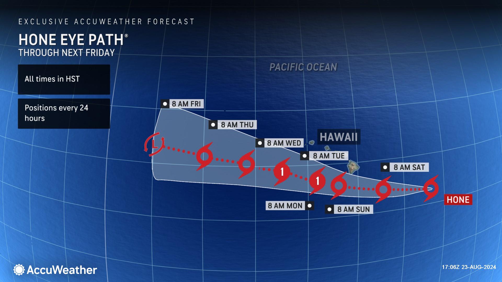
“Tropical Storm Hone formed in the Central Pacific and is moving briskly to the west toward Hawaii. An area of high pressure north of Hawaii is going to be steering this storm,” said AccuWeather Chief On-Air Meteorologist Bernie Rayno.
AccuWeather Lead Hurricane Expert Alex DaSilva says trade winds will pick up across Hawaii as Hone approaches, leading to an elevated risk for wildfires across Hawaii, especially on leeward sides of the Big Island.
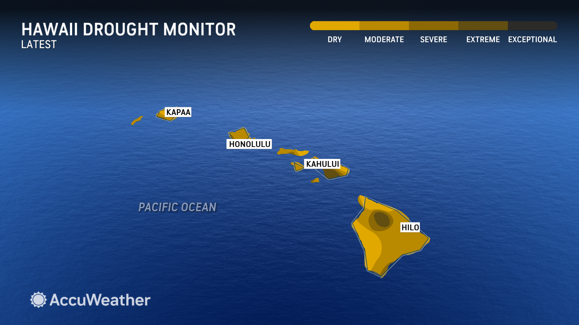
Dry and drought conditions have been reported across the islands recently, with pockets of severe and extreme drought in parts of Maui and the Big Island.
"If Hone loses organization and some of the rain bands fall apart, the lee sides of the mountains may get very little or no rain and may get a lot of wind instead, which could increase the wildfire danger," said DaSilva.
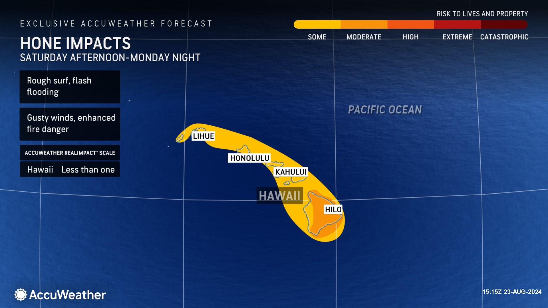
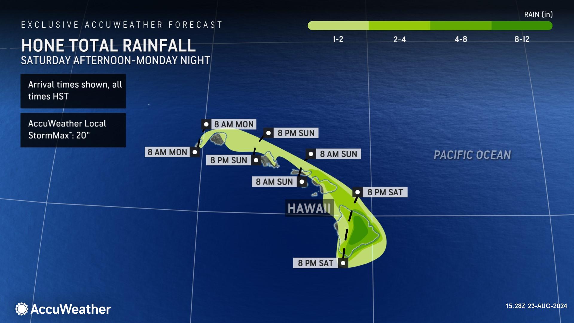
AccuWeather expert meteorologists say Tropical Storm Hone is expected to make its closest approach to the southern Hawaiian Islands by Saturday night and Sunday. As the storm moves past, heavy rain and gusty winds are possible across the Hawaiian Islands, with most of the heavy rain on windward sides of the islands. The heavy rain and strong winds can lead to flash flooding, mudslides, downed trees and power outages. Regardless of the exact track, rough surf and rip currents are expected.
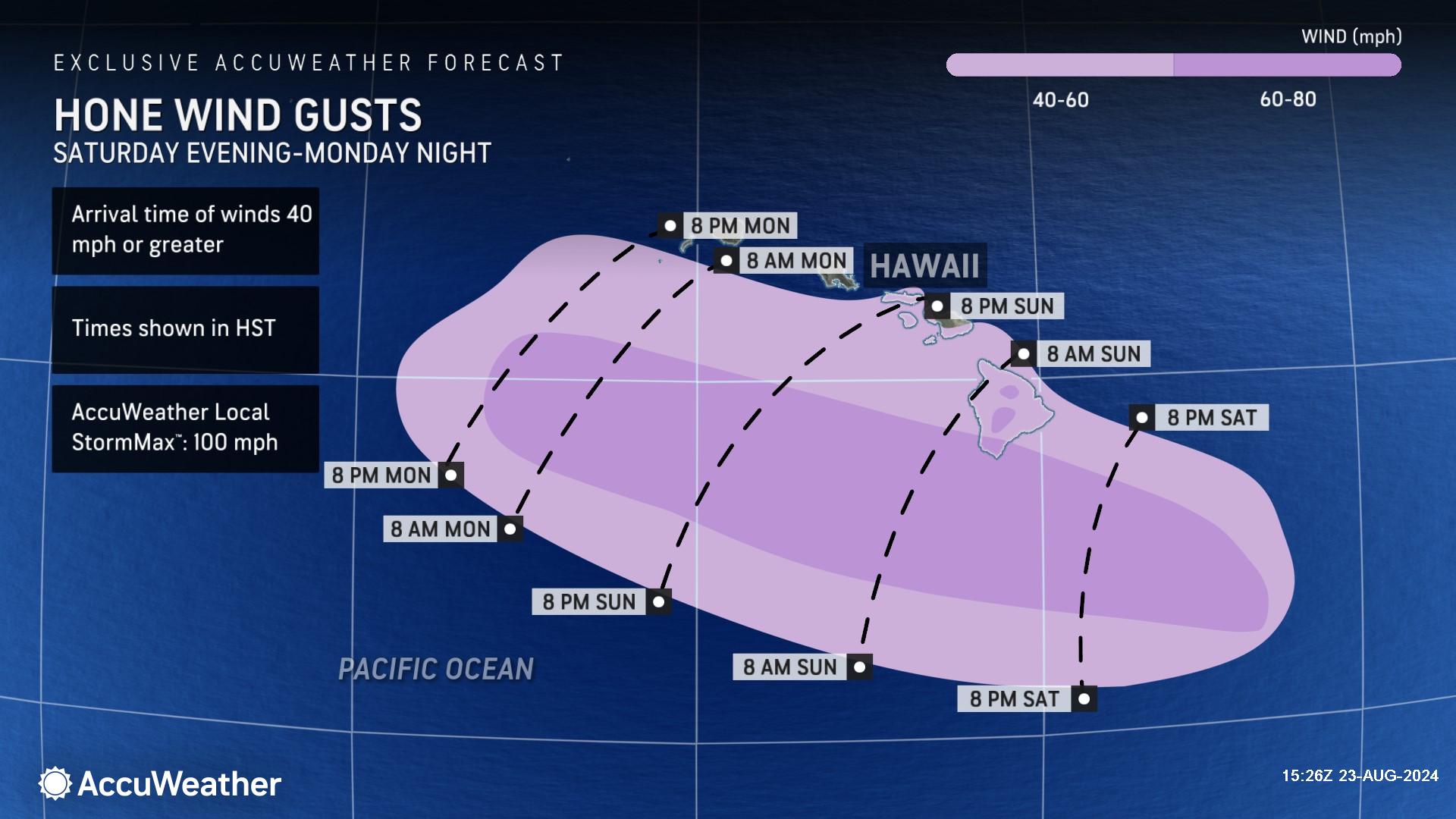
Wind gusts of 40-60 mph are expected across the southernmost islands this weekend with higher gusts of 60-80 mph possible across far southern portions of the Big Island and across the highest elevations, with an AccuWeather Local StormMax™ of 100 mph.
AccuWeather expert meteorologists are forecasting a general 1-2 inches of rainfall across the islands, with higher amounts of 2-4 inches on the Big Island and Maui, and 8-12 inches on the windward side of the mountains of the Big Island, with an AccuWeather Local StormMax™ of 20 inches.
Further strengthening is expected early next week as the storm tracks southwest of Hawaii. Hone is forecast to strengthen to a Category 1 Hurricane on the Saffir-Simpson Hurricane Wind Scale with maximum sustained winds of 74-95 mph by Monday morning.
Due to the impacts from heavy rain and gusty winds, Hone is a less than one on the AccuWeather RealImpact™ Scale for Hurricanes for Hawaii.
A less than one on the AccuWeather RealImpact™ Scale for Hurricanes warns of limited damage from wind and rain, as well as coastal inundation resulting in some property damage.
In contrast to the Saffir-Simpson Hurricane Wind Scale, which classifies storms by wind speed only, the AccuWeather RealImpact™ Scale is based on a broad range of important factors. In order to better communicate a more comprehensive representation of the potential impact of a storm to lives and livelihoods, the scale covers not only wind speed but also flooding rain, storm surge and economic damage and loss. Some of these hazards such as inland flooding and storm surge in many storms result in more deaths and economic loss than wind.
Eye on Hurricane Gilma
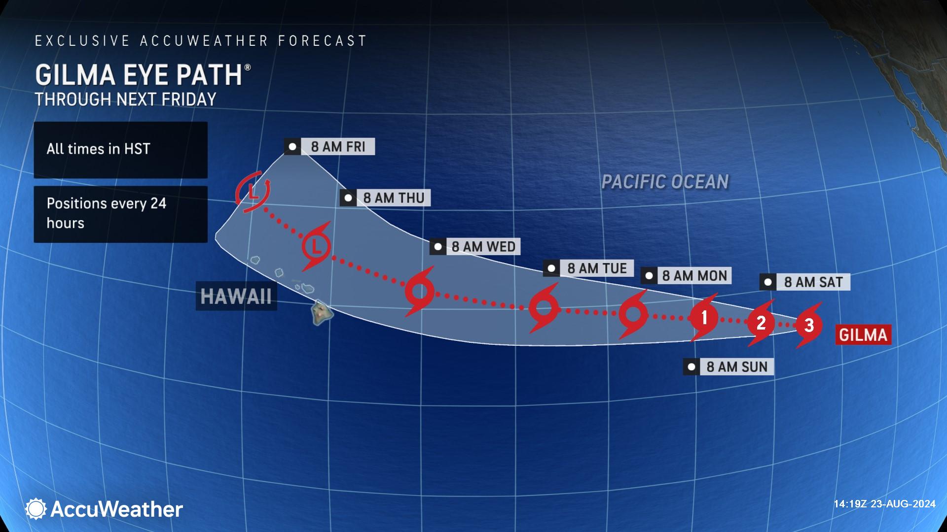
AccuWeather expert meteorologists are closely monitoring Hurricane Gilma as it tracks westward over the open waters of the Pacific Ocean.
As of Friday morning, Hurricane Gilma maintained Category 3 strength on the Saffir-Simpson Hurricane Wind Scale with sustained winds of 111-129 mph.
DaSilva says Gilma is expected to lose wind intensity over the next couple of days as it encounters cooler waters, eventually transitioning to tropical storm status early next week.
Later next week, as Gilma continues along a general westward track, it may approach the Hawaiian Islands with gusty winds and rain. Regardless of the exact track, rough surf and strong rip currents will be possible later next week across portions of the Hawaiian coastlines.
"Should this system hold together, it would not be until around the end of the month before it would become a concern for Hawaii," said DaSilva. "It will have to fight for survival as it gets close to Hawaii. While it will be taking a more direct path toward the islands, it will also be entering waters too cool to allow tropical systems to thrive."
AccuWeather expert meteorologists are also monitoring a third potential tropical threat. A cluster of thunderstorms southwest of the southern coast of Mexico has a high chance of developing this weekend as it passes to the south and southwest of Baja California.
AccuWeather Forecast Graphics
Additional AccuWeather Resources:


