


AccuWeather meteorologists are available 24/7 to provide further insights and updates on evolving weather conditions. Please contact pr@accuweather.com during regular business hours, or support@accuweather.com or call AccuWeather’s Media Hotline at (814)-235-8710 at any time to arrange interviews with AccuWeather experts or to request the most updated graphics for print or broadcast.
Beryl threatens Texas with flooding rainfall and storm surge after slamming the Yucatan Peninsula of Mexico
July 5, 2024

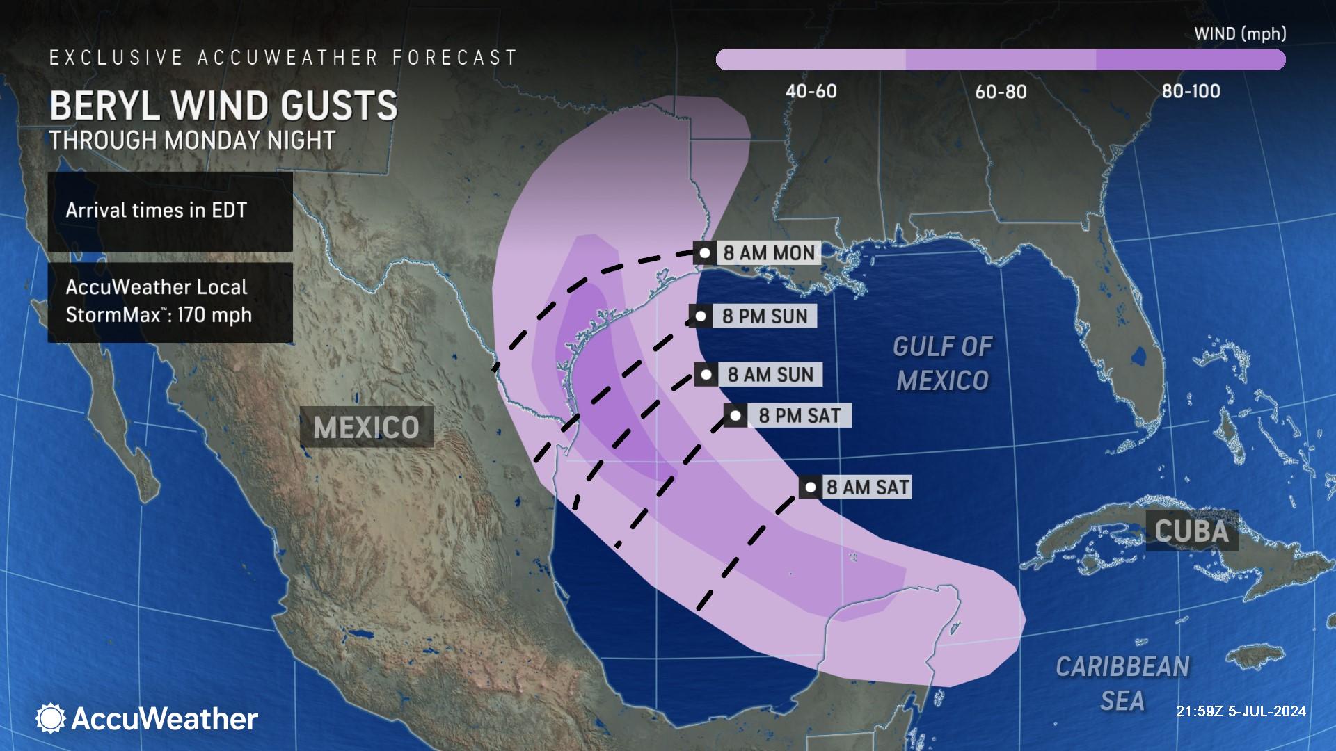
> Wind gusts above 100 mph are possible when Beryl makes landfall in southern
Texas Monday morning
> Drenching rainfall could lead to dangerous flash flooding across Texas next week
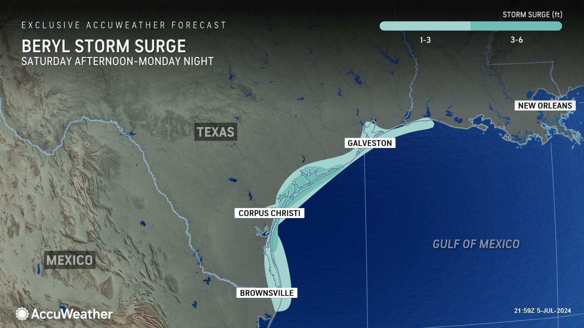
> Up to 6 feet of storm surge could lead to coastal inundation and flooding
> Storm preparations should be completed by Sunday afternoon along the
southern and central Texas coast
AccuWeather Global Weather Center – July 5, 2024
AccuWeather expert meteorologists are sounding the alarm about the growing threat of flooding rainfall, damaging winds, and dangerous storm surge in Texas from Beryl.
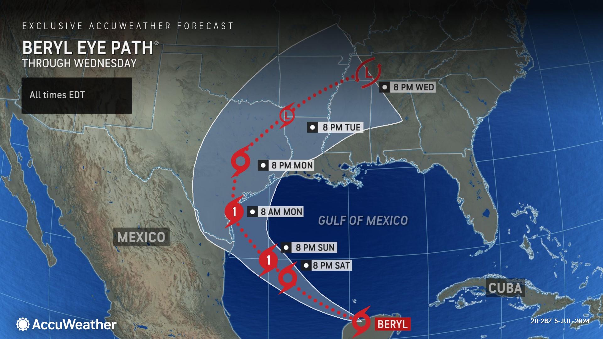
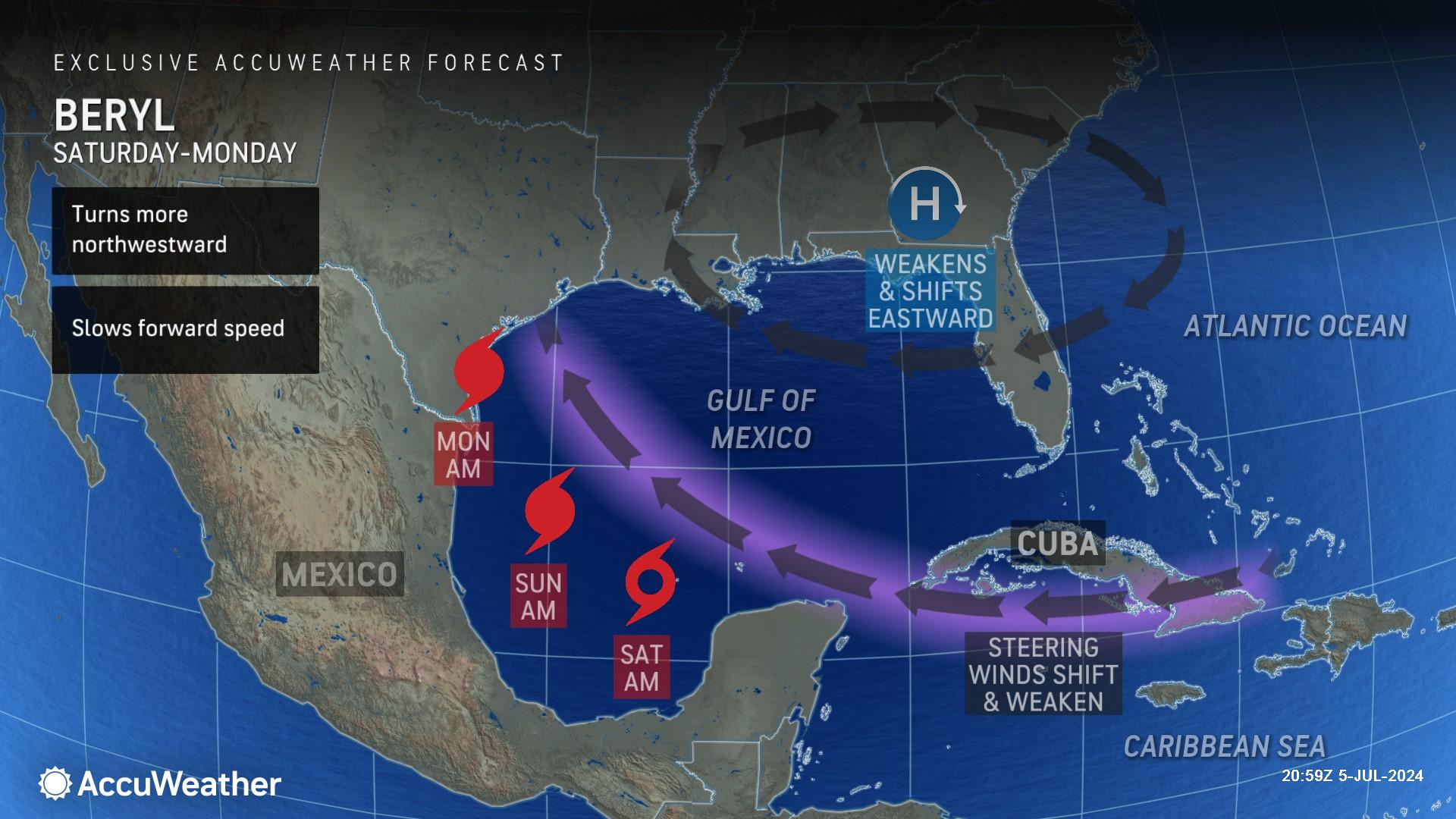
The team at AccuWeather’s Global Weather Center is forecasting Beryl to make landfall in southern Texas as a Category 1 hurricane Monday morning with maximum sustained winds of 74-95 miles per hour on the Saffir-Simpson Hurricane Wind Scale.
AccuWeather meteorologists warn that any wobbles with the center of the storm, and the possibility that the storm may try to turn to the north upon nearing the coast at the last minute, could push landfall significantly farther to the north in Texas.
“As Beryl approaches the Texas coast on Sunday, a dip in the jet stream will act like a magnet and pull the storm more to the north and northwest. Right now, we’re expecting Beryl to make landfall near Corpus Christi as a Category 1 hurricane,” said AccuWeather Chief On-Air Meteorologist Bernie Rayno. “We expect Beryl to slow down as it approaches the Texas coast, and that could cause some big flooding problems.”
The anticipated slower forward speed will increase the duration of wind, pounding surf and storm surge in northeastern Mexico and a large part of the Texas coast.
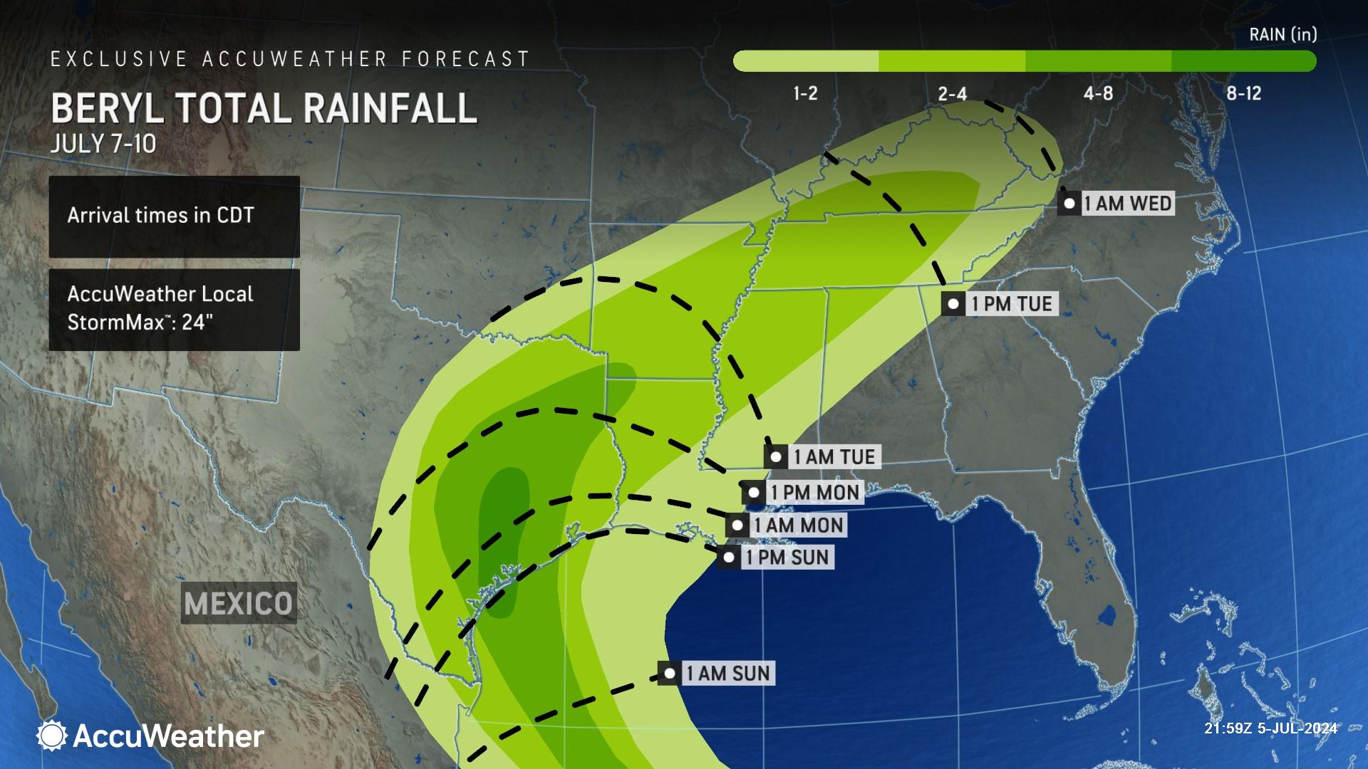
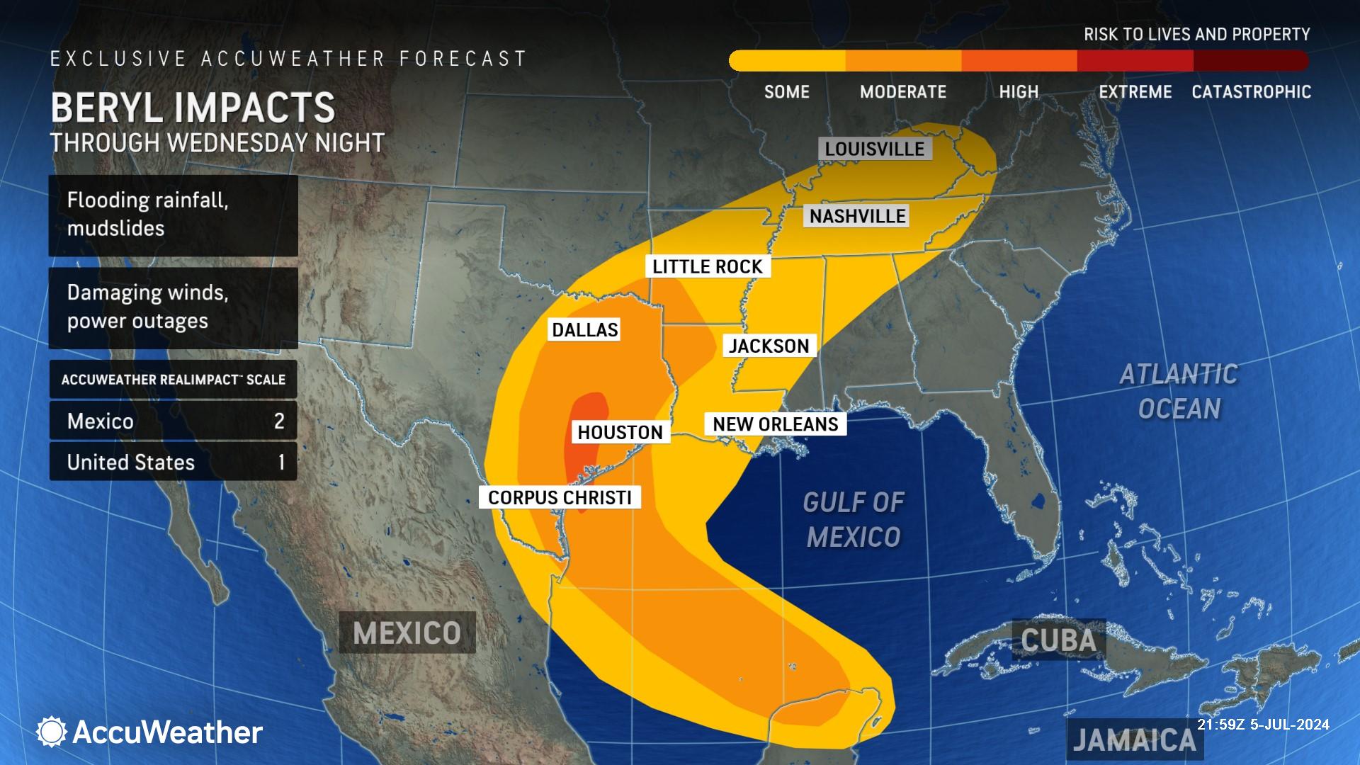
Rainfall from Beryl is expected to arrive in Texas on Sunday. AccuWeather expert meteorologists say 8-12 inches of rainfall is expected along the southern Texas coast and across parts of central and southeast Texas. The hardest-hit areas of Texas could have up to 24 inches of total rainfall, according to the AccuWeather Local StormMax™.
“If that rain comes too fast and too furious, significant and life-threatening flooding can occur. We’ve seen it before with hurricanes in Texas,” said AccuWeather Chief Meteorologist Jon Porter. “Whenever you have a tropical storm or hurricane slowing down, that is a huge red flag for AccuWeather meteorologists because we’re talking about the storm bringing in copious amounts of tropical moisture and the risk for persistent downpours over the same areas which can lead to major flooding in the hardest hit areas.”
Beryl could push 3-6 feet of storm surge into coastal areas along the southern Texas coastline. AccuWeather expert meteorologists say 1-3 feet of storm surge is possible far north as Galveston Bay.
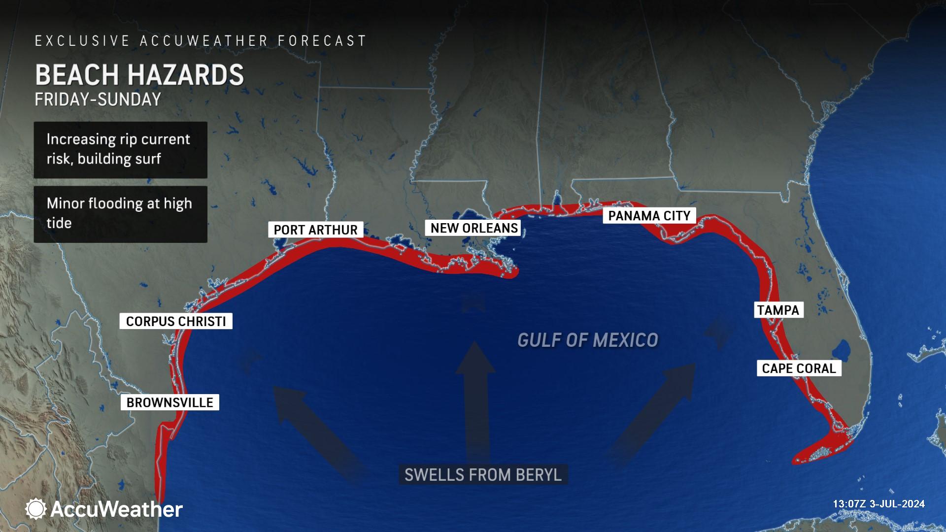
Swells from Beryl are expected to create dangerous rip currents and rough surf along Texas beaches today through next Tuesday. The risk of rip currents could stretch across the entire U.S. Gulf Coast this weekend, creating beach hazards as far away as southwest Florida.
“With so many people that are going to be in the water along the Gulf of Mexico this weekend, the impacts from Beryl can be far-reaching. We’ve seen that with other hurricanes in years past that have tragically taken many lives in the surf zone due to rip currents, occurring under blue skies hundreds of miles away from the storm,” said Porter. “The rip current risk is real and it could be a dangerous weekend in some areas considering many people will be in the water on a hot, holiday weekend along the Gulf Coast. Be aware of that risk, follow the direction of local officials and lifeguards, and know how to react if you encounter a rip current at the beach.”
AccuWeather expert meteorologists say strong winds from Beryl are expected to arrive in southern Texas later Sunday, then spread up the coast through Sunday night.
AccuWeather expert meteorologists say they cannot rule out the possibility that Beryl could strengthen to a Category 2 hurricane before making landfall, with maximum sustained winds of 96-110 mph on the Saffir-Simpson Hurricane Wind Scale.
Changes in forward speed and the angle at which Beryl approaches the coast will determine the precise time of landfall, as well as the extent and magnitude of storm surge flooding. For example, Beryl could slow down or turn more to the north, paralleling more of the coast at the last minute before landfall. This could bring greater coastal impacts even farther north along the Texas coast, even around Houston.
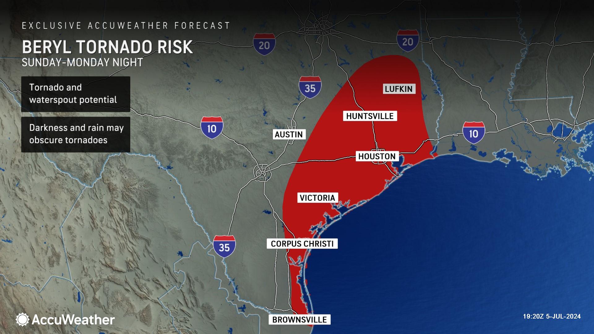
AccuWeather expert meteorologists warn that tornadoes and waterspouts are also possible in Texas next week as Beryl moves inland. Some tropical systems bring a swarm of tornadoes upon making landfall, while others bring very few tornadoes. If dry air can spiral into the storm's circulation as it moves onshore, the risk of severe thunderstorms and tornadoes may increase, particularly over the storm's eastern and northeastern sections.
The AccuWeather RealImpact™ Scale for Hurricanes in the United States is a 1, which warns of localized flooding, damage to unanchored mobile homes, localized power outages and coastal inundation resulting in property damage.
The slower the storm moves over land next week, the greater the potential magnitude of flooding in portions of northeastern Mexico and southeastern Texas. In the past, tropical storms that have slowed to a crawl or stalled over a region have unleashed tremendous rainfall that led to catastrophic flooding in Texas. However, every storm and every situation are different and even storms with a faster forward speed can still bring copious amounts of rainfall and widespread flooding.
While atmospheric steering winds may decrease for a time, enabling Beryl’s downpours to linger over the same areas at least for a time, increasing the flooding risk, AccuWeather meteorologists do not currently expect Beryl to stall. Instead, Beryl now appears poised to increase its forward speed again upon reaching northeastern Texas and accelerate northeastward toward the Tennessee Valley as a tropical rainstorm. Beryl could eventually bring flooding rainfall to parts of the lower Mississippi Valley into Tennessee and Kentucky toward the middle of next week.
Beryl expected to restrengthen after crossing the Yucatan Peninsula
Damage was reported in the Tulum area of Mexico’s Yucatan Peninsula after Beryl made landfall as a Category 2 hurricane Friday morning.
AccuWeather expert meteorologists say Beryl lost wind intensity as it crossed over the Yucatan Peninsula today, but it will regain intensity once it reaches the warm waters of the Bay of Campeche and Gulf of Mexico.
“Water temperatures are in the lower 80s in the Bay of Campeche; that will help Beryl gain intensity. There is a lot of dry air to the north and west of the storm, but Beryl is pushing that dry air out of the way,” said Rayno. “The only factor hurting Beryl this weekend will be disruptive wind shear.”
Beryl shattered records earlier this week as the earliest Category 5 hurricane to form in the Atlantic basin, causing catastrophic damage and claiming several lives when it blasted through the Windward Islands.
AccuWeather Forecast Graphics

Additional AccuWeather Resources:
Hurricane Beryl to target Texas next with flooding rain, strong winds and storm surge
Beryl pummels Jamaica, Cayman Islands as death toll rises
Category 5 Hurricane Beryl rewrites the record books
What is wind shear and how does it impact hurricanes, other tropical cyclones?
AccuWeather Forecasts Explosive 2024 Hurricane Season
Rapidly Intensifying Hurricanes Near Coastline Pose Major Threat To U.S. This Season
Hurricane season: AccuWeather's guide for first-timers
The warning signs of rip currents
How to avoid the potentially deadly grip of a rip current


