


AccuWeather meteorologists are available 24/7 to provide further insights and updates on evolving weather conditions. Please contact pr@accuweather.com during regular business hours, or support@accuweather.com or call AccuWeather’s Media Hotline at (814)-235-8710 at any time to arrange interviews with AccuWeather experts or to request the most updated graphics for print or broadcast.
Tropical Rainstorm is expected to strengthen into a hurricane as it takes aim at the Caribbean
June 27, 2024

> Tropical threat in the central Atlantic is expected to strengthen to a tropical
storm as it approaches the Windward Islands

> Conditions are expected to be favorable for intensification next week

> AccuWeather expert meteorologists expect this tropical rainstorm to continue
to strengthen into the first hurricane of the season
AccuWeather Global Weather Center – June 27, 2024
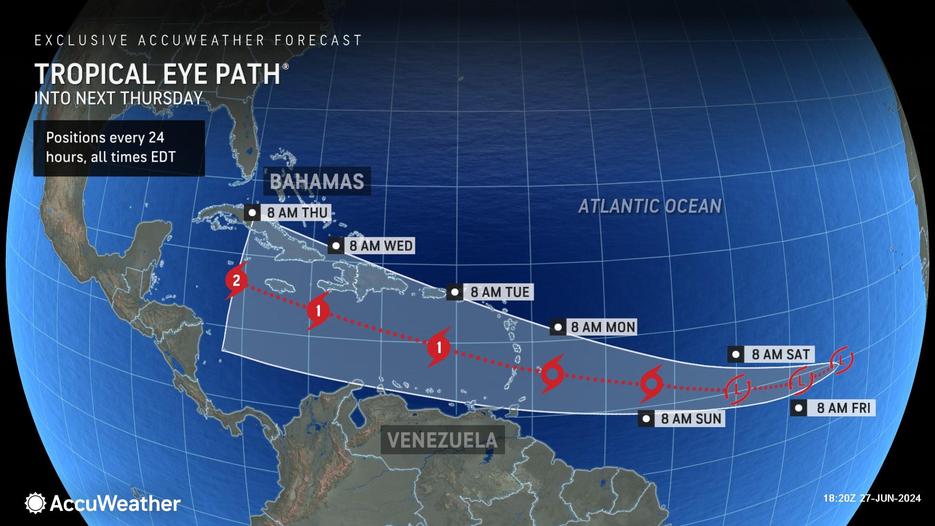
A tropical rainstorm brewing in the central Atlantic is expected to strengthen into a tropical storm in the next 48-72 hours.
AccuWeather expert meteorologists issued an AccuWeather Forecast EyePath® Thursday afternoon.
Due to the high risk of tropical development, AccuWeather began referring to the threat as a tropical rainstorm Thursday morning to help raise public awareness of the risk to lives and property.
The tropical rainstorm is expected to trek west and strengthen into a tropical storm by the time it reaches the Windward Islands on Monday. Some of the islands may experience tropical storm conditions with drenching downpours, gusty thunderstorms, and rough surf as early as Sunday.
There is the chance that it reaches hurricane intensity as it approaches the Islands. A storm becomes a hurricane when maximum sustained winds reach 74 mph.
AccuWeather expert meteorologists say this storm is expected to strengthen to a hurricane south of Puerto Rico on Tuesday, if not sooner.
“The AccuWeather Forecast EyePath® calls for further intensification to a Category 2 hurricane south of Cuba by Thursday. A Category 2 storm has maximum sustained winds of 96-110 mph,” said AccuWeather Senior Meteorologist Marshall Moss. “With warm waters and the potential for conditions to favor faster intensification, it is not out of the realm of possibilities that it reaches major hurricane status over the eastern or central Caribbean next week.”
A major hurricane is a storm that reaches Category 3 strength on the Saffir-Simpson scale, with sustained winds of 111 mph or greater.
“By late next week, this tropical threat could end up as far north as the western Gulf of Mexico, or as far south as Central America,” said AccuWeather Chief On-Air Meteorologist Bernie Rayno.
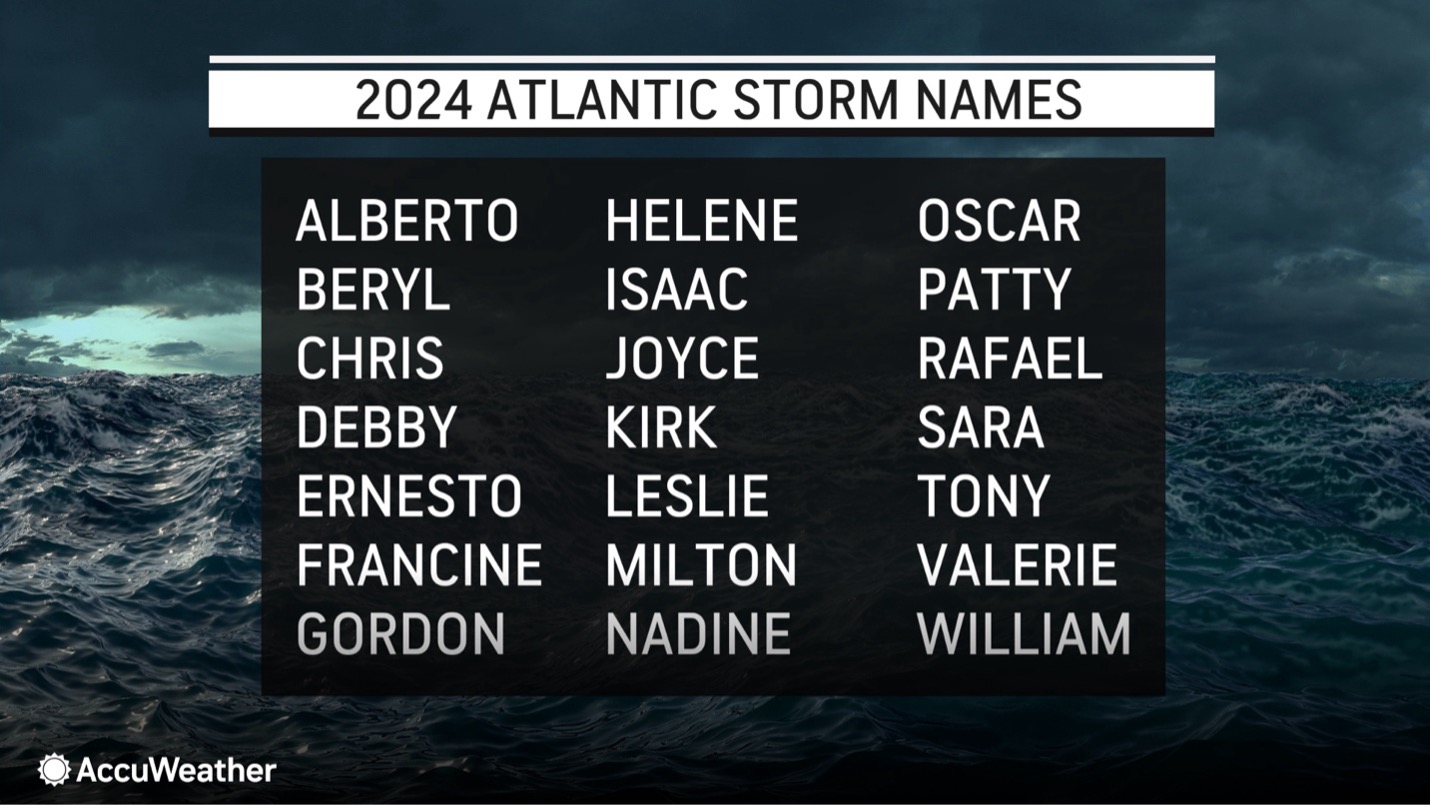
The next name on the list of Atlantic storms in the Atlantic Basin is Beryl.
“This could develop into the first hurricane of the season next week,” said AccuWeather Senior Director of Forecasting Operations Dan DePodwin. “We expect this to be a strong tropical storm as it approaches Barbados late Sunday into early Monday. It could be a hurricane if it strengthens a little faster.”
Favorable Conditions for an ‘Explosive’ Hurricane Season
AccuWeather expert meteorologists say such vigorous activity in the Atlantic, especially east of the Lesser Antilles, is rather unusual this early in the season.
The Main Development Region is an area of the central Atlantic Ocean where storms frequently develop. Storms typically do not strengthen over the Main Development Region until the middle of August or later. The period from late June through much of July is typically quiet, with only one or two named systems by the middle to end of July.
"We continue to observe much higher-than-historical-average water temperatures over most of the Atlantic, and this is the premise for the robust activity now,” said AccuWeather Senior Storm Warning Meteorologist Eddie Walker. “AccuWeather has been anticipating a super-charged hurricane season for 2024 since this past winter, highlighting that risk ahead of other sources.”
Interaction with South America and the larger islands of the Caribbean, as well as bouts of disruptive wind shear and dry air, may inhibit development and intensification as the system moves west. However, should the system stay in the moist zone and away from large land areas, it has the potential to intensify quickly.
"Steering winds in the atmosphere will guide the system to near the Windward Islands of the eastern Caribbean from Sunday night to Monday morning, then waters near Jamaica during the middle of next week and perhaps to the shores of Central America at the end of next week," said Walker.
Depending on steering winds, the system may push westward across Central America later next week or turn northwestward and reach the western Gulf of Mexico next weekend, where it would become a concern for the United States.
“Typically we wouldn’t be worried about tropical development this far east at this time of year. Usually in the Atlantic Basin, at this time of year, there is too much disruptive wind shear and too much dry air. This tropical rainstorm is south of the area with dry air and wind shear. Without wind shear and dry air, and plenty of warm water, I’m concerned this tropical rainstorm is going to have plenty of room to develop,” explained Rayno. “We expect a big upper-level high-pressure area over Florida late next week. If that’s the case, that should drive the tropical threat further south.”
AccuWeather expert meteorologists caution families, tourists, and businesses in the Caribbean, Central America, and along the Gulf Coast of the United States to monitor forecast updates closely.
“Any impact to the United States, if it occurs, would not be until July 8 or later,” said DePodwin. “There is the potential, if the conditions remain favorable, that we could be dealing with a major hurricane in the Caribbean next week.”
Prepare for Rapidly Intensifying Tropical Threats This Summer
Sea-surface temperatures are at record high levels and warm water temperatures have expanded hundreds of feet below the surface across pockets of the Atlantic Basin.
AccuWeather Lead Hurricane Expert Alex DaSilva says everyone along America’s Atlantic and Gulf Coasts needs to prepare for the threat of rapidly intensifying storms that can leave families, businesses, and emergency officials with less time to react, prepare, and evacuate.
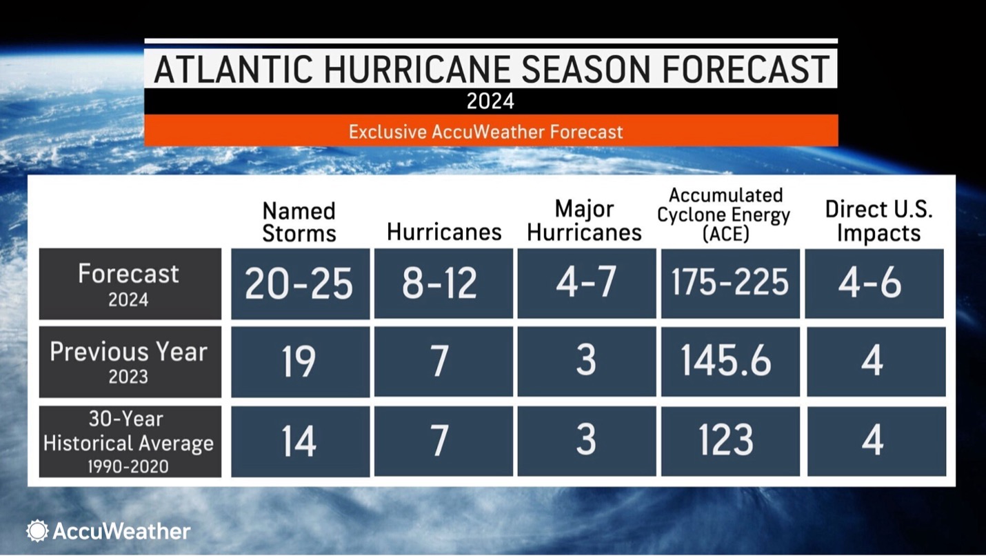
“We are forecasting 20-25 named storms, significantly higher than the historical average of 14 named storms. We expect 4-7 of those storms to strengthen into major hurricanes this year; that’s a Category 3 hurricane or higher,” said DaSilva. “Sea surface temperatures are well above historical average in many places. That warm water can act like jet fuel, helping storms quickly develop and intensify.”
DaSilva said there is the potential of 30 or more named storms this year in the Atlantic Basin. Surpassing 30 named storms would break the record that was set in 2020.
AccuWeather expert meteorologists warned in March that the coastlines of Texas, the Florida Panhandle, South Florida, and the Carolinas face a higher risk of direct impacts this hurricane season, compared to the historical average.
Additional AccuWeather Resources:


