AccuWeather meteorologists are available 24/7 to provide further insights and updates on evolving weather conditions. Please contact pr@accuweather.com during regular business hours, or support@accuweather.com or call AccuWeather’s Media Hotline at (814)-235-8710 at any time to arrange interviews with AccuWeather experts or to request the most updated graphics for print or broadcast.
Beryl Strengthens into Major Hurricane, Threatening Caribbean with Destructive Winds and Storm Surge
June 30, 2024
> The second named storm of the season is expected to strengthen into a
dangerous Category 4 hurricane

> Beryl is forecast to bring winds above 140 mph and 6-10 feet of storm
surge to parts of the Caribbean

> AccuWeather is forecasting an ‘extreme’ risk to lives and property in the
parts of the Lower Antilles
AccuWeather Global Weather Center – June 30, 2024
AccuWeather expert meteorologists say the second named Atlantic storm of the season is rapidly intensifying and poses an ‘extreme’ risk to lives and property in parts of the Lesser Antilles.
AccuWeather expert meteorologists say Beryl intensified into a Category 3 hurricane on Sunday morning with maximum sustained winds of 115 mph.
Beryl is expected to further intensify into a Category 4 hurricane Sunday evening, packing deadly storm surge, destructive winds and flooding rain.
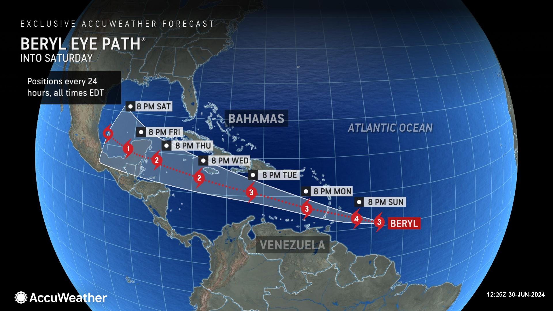
“Beryl has rapidly intensified into a dangerous major hurricane. It’s rare to see a storm rapidly intensify this fast, this early in the season, in this part of the Atlantic. Several islands across the Lower Antilles are facing an extreme risk to lives and property,” warned AccuWeather Lead Hurricane Forecaster Alex DaSilva. “Beryl is strengthening in an area with favorable conditions for tropical development. There is nothing to slow this storm down before it hits Saint Vincent and the Grenadines.”
AccuWeather was the first known source to issue a warning about the looming threat of a hurricane brewing in the Atlantic on June 27. AccuWeather began referring to the system as a tropical rainstorm on Thursday morning to help raise public awareness of the risk to lives and property along the storm's path.
The AccuWeather Forecast Eye Path® was first issued Thursday afternoon to alert families, businesses and leaders across the Caribbean about the imminent public safety threat to lives and property.
The National Hurricane Center issued its first track forecast cone on the afternoon of June 28, more than 24 hours after the first AccuWeather Forecast Eye Path® was issued.
“Beryl rapidly intensified from 60-mph winds to 115-mph winds in the span of just 24 hours,” said DaSilva.
Extreme Risk to Lives and Property
Tropical Storm Beryl strengthened to a Category 1 hurricane on Saturday afternoon with winds of 75 mph, just 24 hours after the system first formed as a tropical depression over the Atlantic Ocean. Beryl was trekking west at 21 mph Sunday morning, which is a brisk pace for a hurricane.
Beryl became the first major hurricane of the season Sunday morning, reaching Category 3 strength with sustained winds above 111 mph.
"The hurricane will continue to be steered west-northwestward across the Caribbean Sea by a large area of high pressure through the middle of this week,” said DaSilva.
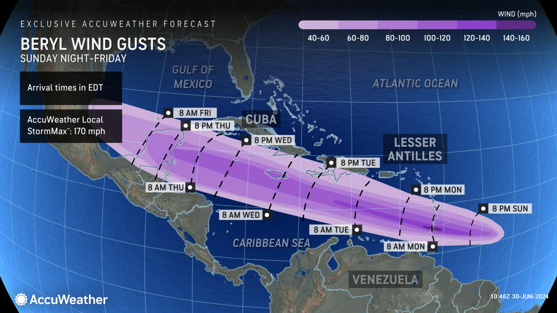
AccuWeather expert meteorologists are forecasting Beryl to strengthen to a Category 4 hurricane, packing maximum sustained winds above 140 mph as it moves through the Lesser Antilles. Destructive wind gusts as high as 170 mph are possible in areas that will be hit hardest by Beryl over the next 48 hours, according to the AccuWeather Local StormMax™. Winds of this magnitude can damage and destroy structures and send loose objects flying, compounding the damage. AccuWeather meteorologists urge those in the path to take immediate action; get to safe shelter in sturdy buildings that can withstand powerful winds, and away from areas that could be impacted by storm surge inundation.
Parts of Saint Vincent and the Grenadines could experience 6-10 feet of storm surge from Beryl, according to AccuWeather.
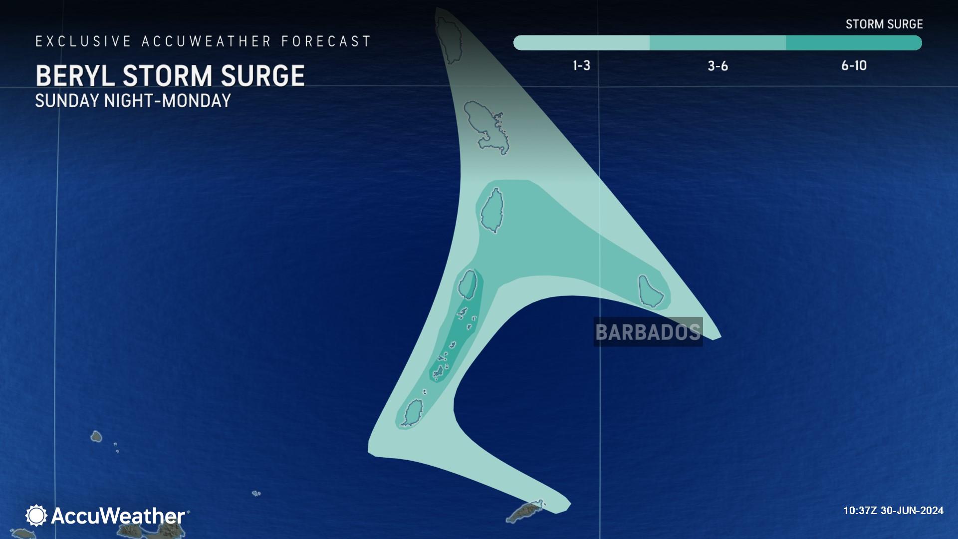
AccuWeather expert meteorologists say parts of Bermuda, Saint Lucia, and Grenada could receive 1-3 feet of storm surge from Hurricane Beryl.
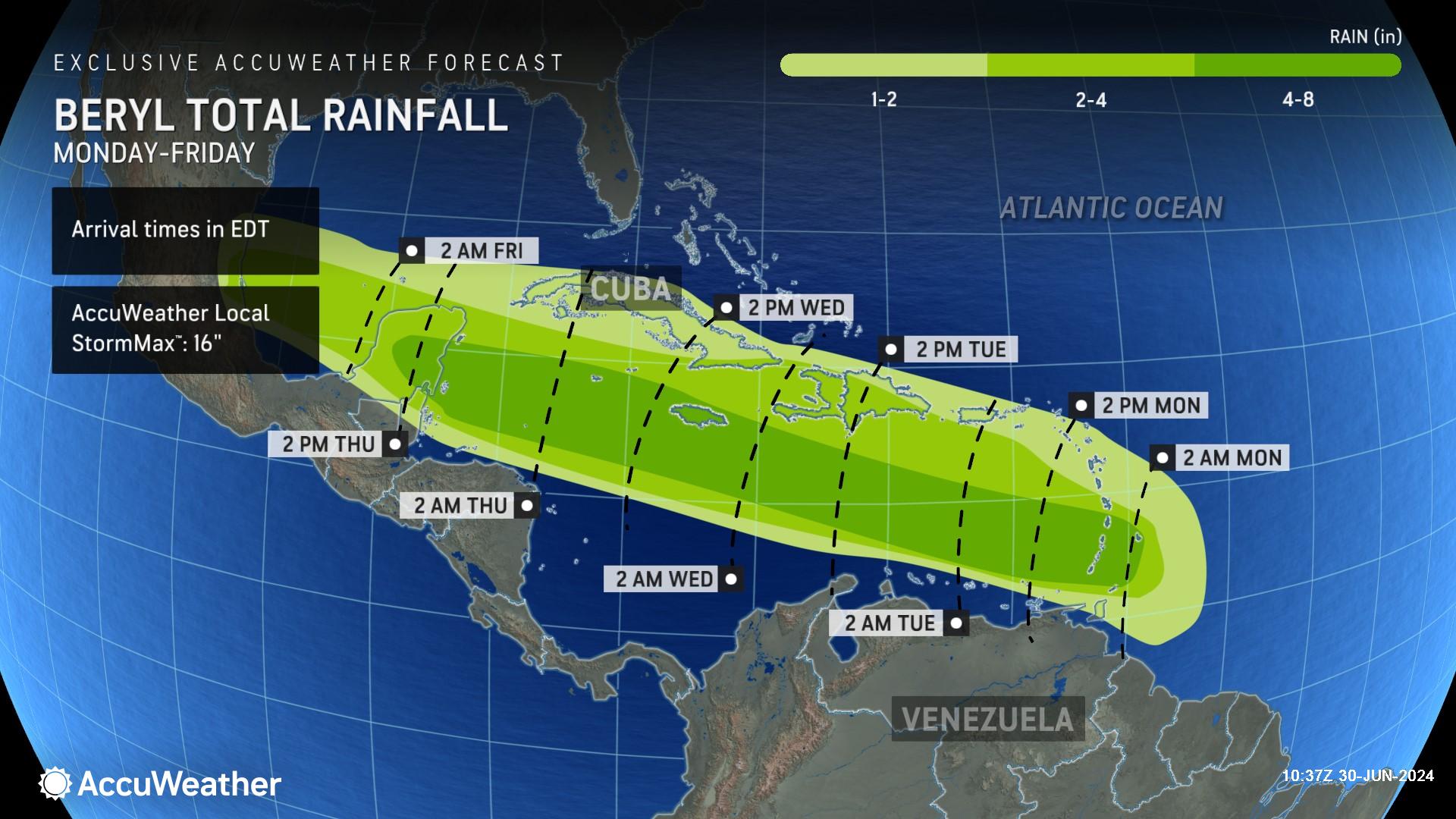
Most islands in the direct path of Beryl could get 4-8 inches of rainfall, with an AccuWeather Local StormMax™ of 16 inches of rain.
The AccuWeather RealImpact™ Scale for Hurricanes is a 4 for the Lesser Antilles in the eastern Caribbean.
A 4 on the AccuWeather RealImpact™ Scale for Hurricanes warns of widespread catastrophic flooding, widespread power outages, structural damage to many buildings and severe coastal inundation.
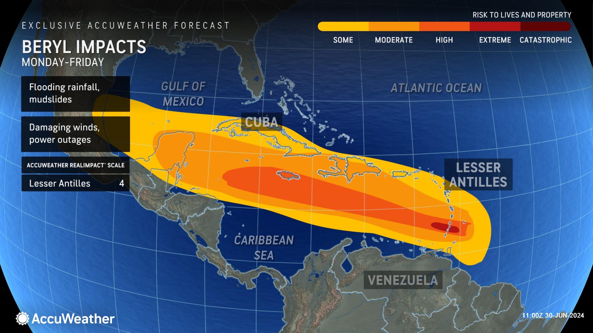
AccuWeather's unique scale communicates a more comprehensive representation of a storm's potential impact so people can make informed weather-impacted decisions. The Saffir-Simpson Scale uses only wind speed to determine the category of each storm.
Where is Hurricane Beryl Headed Next?
Interaction with the larger islands of the Caribbean, as well as bouts of wind shear (winds at different directions at different levels of the atmosphere, which are not conducive to tropical development/strengthening) and dry air, may still become inhibiting factors to the storm reaching its full potential. However, AccuWeather expert meteorologists now expect the impact of these factors will be minimal, allowing Beryl to maintain strength as it moves through the Caribbean.
Beyond its trek through the Caribbean, all eyes will turn toward the United States. AccuWeather expert meteorologists say that while the most likely scenario is a westward track into Mexico, residents along the Gulf coast should not let their guard down.
“At this point, the most likely scenario is for this storm to move westward into Mexico, but no one should let their guard down,” warned DaSilva. “If the area of high pressure across the southeast United States weakens, that could allow the storm to move farther north and potentially directly impact the Gulf Coast of the U.S. People along the Texas coast need to closely monitor forecast updates.”
AccuWeather expert meteorologists issued an alert in May, warning that the growing trend of rapidly intensifying hurricanes could leave families, businesses and officials with less time to react, prepare and evacuate before a landfall.
“Everyone along the Gulf and Atlantic coastline of the U.S. needs to be prepared for the threat of rapidly intensifying hurricanes this season, similar to what we are seeing with Beryl right now,” said DaSilva.
Hurricane Beryl Becomes a Historic Storm
Water temperatures that are well above the historical average are one of the primary factors fueling rapid intensification.
Some pockets of sea-surface temperatures are in record territory.
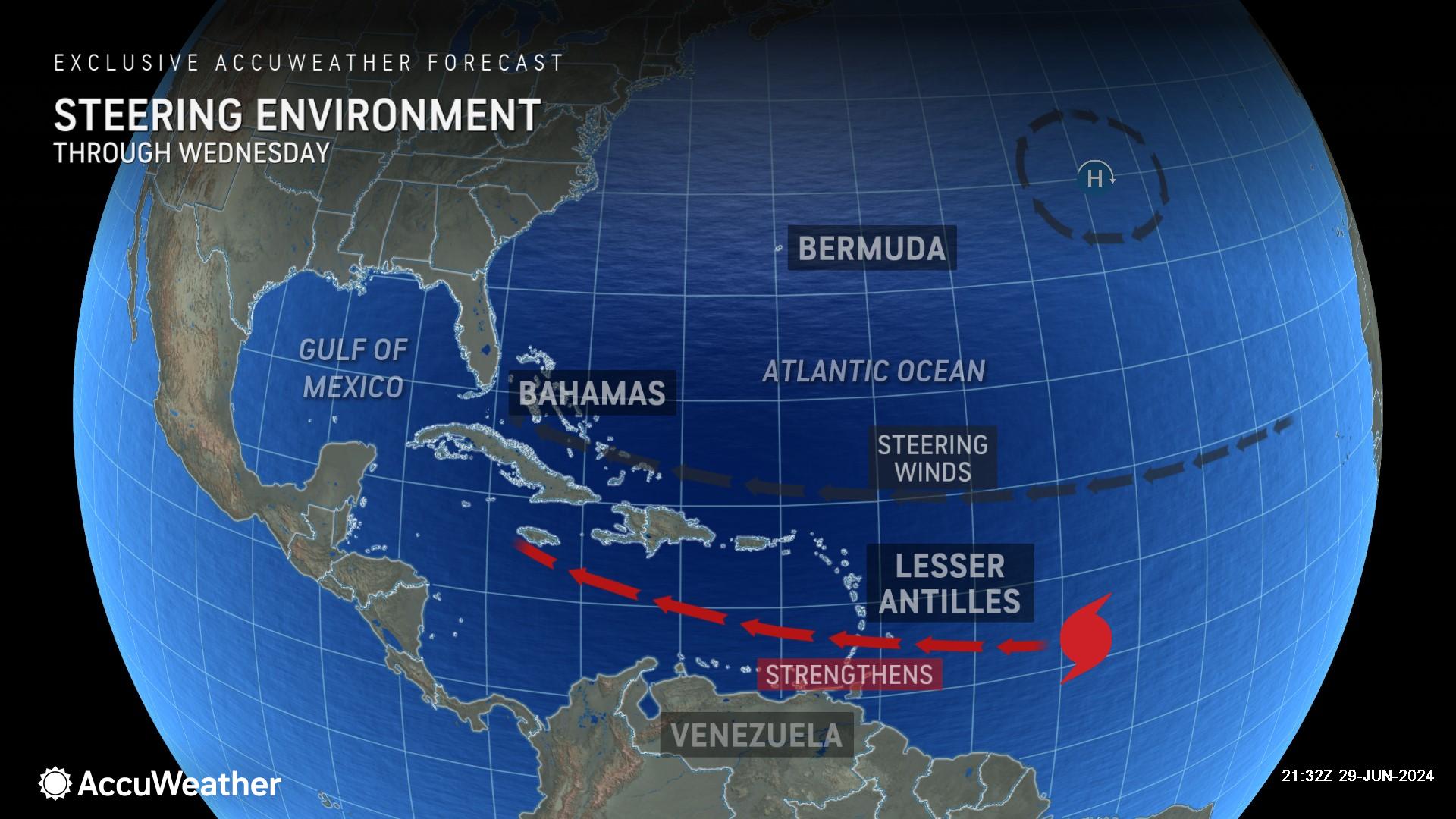
DaSilva says tropical storms and hurricanes in the central and eastern Atlantic are rare this early in the season. This area of the Atlantic, known as the “Main Development Region”, does not typically spawn tropical storms and hurricanes until mid-August or later.
Beryl may not be the last early-season tropical storm or hurricane to form in the central or eastern Atlantic Ocean. AccuWeather hurricane experts are monitoring another area of potential development to the east of Beryl.
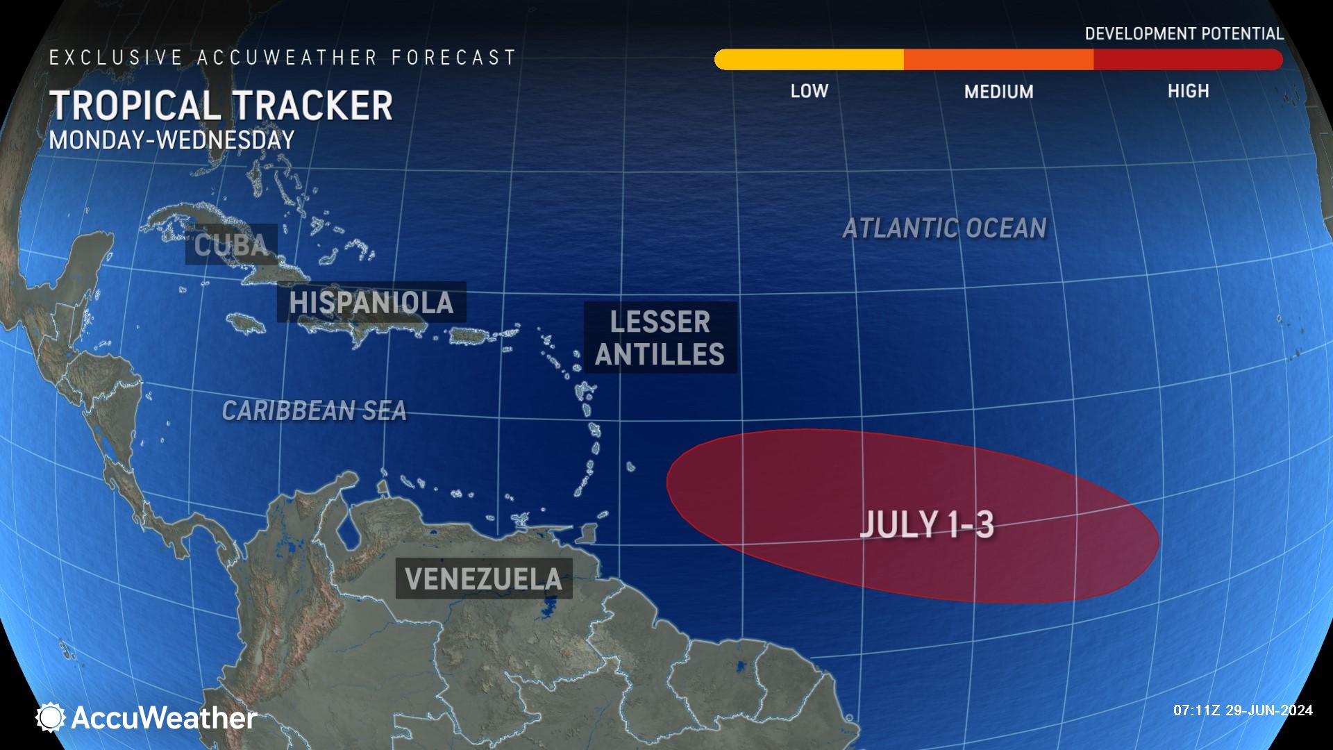
"This storm is expected to follow a track very similar to Beryl and can be near the Lesser Antilles around July 3-4 and could eventually bring very heavy rain to portions of the Greater Antilles," said DaSilva.
Additional AccuWeather Resources:


