



AccuWeather meteorologists are available 24/7 to provide further insights and updates on evolving weather conditions. Please contact pr@accuweather.com during regular business hours, or support@accuweather.com or call AccuWeather’s Media Hotline at (814)-235-8710 at any time to arrange interviews with AccuWeather experts or to request the most updated graphics for print or broadcast.
Major Pattern Shift Brings Threat Of Severe Thunderstorms With Widespread Wind Damage To 20 States Over The Coming Weeks
June 7, 2024

-
>   Heightened risk of thunderstorms with destructive wind gusts from the Dakotas
to the Great Lakes and mid-Atlantic from mid-June through mid-July

>   Conditions are favorable for long-lived intense thunderstorm clusters and even
one or more derechos that can pack winds gusting above 80 mph

>   Pattern shift favoring damaging thunderstorm winds follows stormy spring with more than 1,000 preliminary tornado reports so far this year, making 2024 the most active severe weather year thus far since 2011 and the 2nd most active thus far
since 1950.
AccuWeather Global Weather Center – June 7, 2024
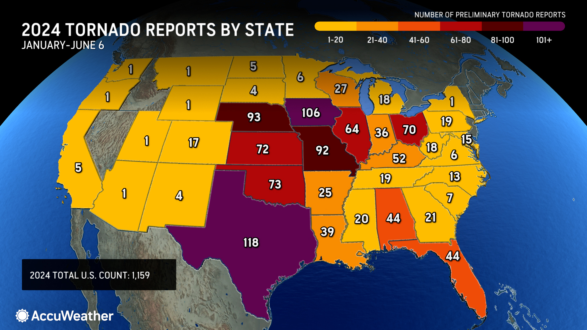
Families and businesses are still recovering and rebuilding after more than 1,000 tornadoes tore across 38 states so far this year. AccuWeather expert meteorologists say there is a major pattern shift on the horizon that will lead to different types of severe weather hazards heading into summer.
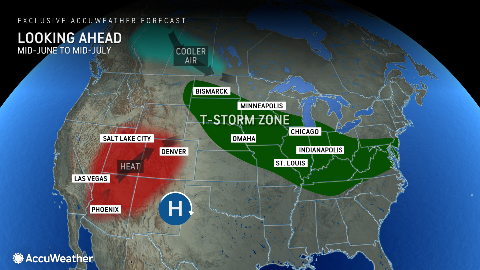
AccuWeather Chief Meteorologist Jon Porter says the big pattern shift will lead to an increased threat of damaging thunderstorms and possible derechos.
“An area of high-pressure is forecast to amplify over parts of the Southern United States. This is the big heat dome that has been bringing heat and persistent drought to Mexico, that’s going to build to the north. The jet stream is going to accordingly shift further north. The corridor dealing with those persistent thunderstorms will also slide to the north from the Dakotas to Midwest to parts of the Great Lakes, including the Ohio and Tennessee Valleys, even as far east as the mid-Atlantic,” explained Porter. “The severe weather risk is evolving toward fast-moving thunderstorm clusters which are notorious for producing destructive winds over a large area.”
There is also an increased risk of at least one derecho in this area over the coming weeks. AccuWeather expert meteorologists say a derecho is a thunderstorm complex with a width of at least 60 miles that travels along a path of at least 400 miles. The thunderstorm complex must have wind gusts of at least 58 mph over this path to be categorized as derecho. Flash flooding, large hail, isolated tornadoes, and wind gusts topping 100 mph are also possible in a derecho.
“Sometimes it can feel like an inland hurricane, although it’s a completely different meteorological setup. Sometimes the most intense clusters of storms can produce damaging wind gusts of 80-100 miles per hour along a long track,” said Porter.
Communities hit hard by tornadoes and severe storms this spring in Nebraska, Iowa, Illinois, and Ohio could be impacted by the shift in severe weather threats over the next few weeks. Severe thunderstorms, wind gusts, flash flooding, hail, and lightning could disrupt recovery and rebuilding efforts.
“There will not be any rest for people across the Midwest that have been dealing with rounds of tornadoes. Now there are more concerns around damaging winds,” said Porter. “We’re not saying that’s going to occur over the entire path, but those are the areas that we’re going to want people to be especially weather aware over the next couple of weeks and checking the AccuWeather forecast more often than they typically do.”
Derechos have a history of causing widespread damage and leaving hundreds of thousands of people without power and air conditioning in the summer heat.
A derecho with multiple tornadoes that raced across southeast Texas last month left more than a million people without electricity for days with AccuWeather RealFeel® temperatures soaring above 100 degrees. AccuWeather estimated the total damage and economic loss from the storms in the Houston metro area at $5-7 billion.
A derecho last summer blasted through part of the Midwest with 100 mph wind gusts, flattening entire corn fields and leaving 500,000 customers without electricity.
An intense derecho in August 2020 blasted parts of Iowa with wind gusts approaching 140 mph. The massive complex of storms traveled nearly 800 miles across the Midwest in 14 hours. Destructive wind gusts damaged homes, businesses, apartment buildings, and farm equipment. Officials in Cedar Rapids, Iowa said the derecho damaged or destroyed nearly 70 percent of the tree canopy in the city.
Tornado Reports Trending Well Above The Historical Average
There is a reduced threat of tornadoes with this major pattern shift, but AccuWeather expert meteorologists warn that derechos and severe thunderstorms with destructive wind gusts can cause similar damage to that of a tornado.
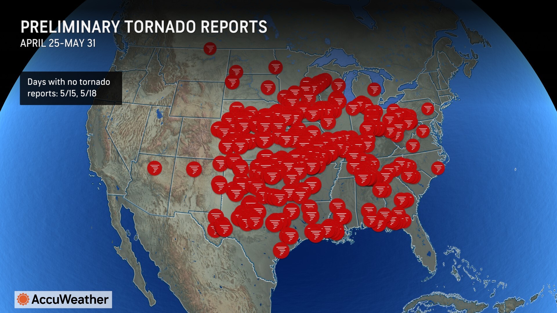
The tally of preliminary tornado reports across America has topped the 1,100 mark, well above the historical average of 792 tornadoes for this time of year. Tornadoes have been reported across 38 states this year.
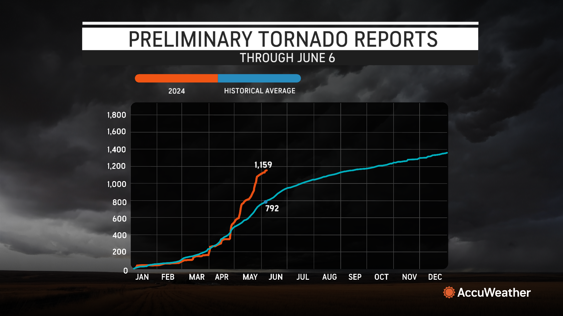
“We were actually below the historical average for much of this year,” explained AccuWeather Chief On-Air Meteorologist Bernie Rayno. “It’s not like we’ve seen a big tornado season. It was consolidated to a 30-day period”.
Rounds of severe weather and tornado outbreaks in April and May lead to a spike in tornado reports.
“As soon as we hit that late April time period, it’s like a hockey stick, way above the long-term historic average,” said Porter. “Now we’re actually at the most active severe weather season since 2011 and the number two most active since 1950. That puts the recent incredibly active severe weather pattern into perspective. So many communities have had tornado impacts. Some of these have been particularly strong tornadoes with lots of damage and tragically some fatalities, but I’m confident that many lives have been saved by people receiving early warnings and taking the quick action needed to save their life!”
Porter urges families and businesses to stay connected and prepared for severe weather impacts this summer, which could result in extended power outages during hot and humid conditions, making such power outages especially dangerous, especially if they become prolonged.
Additional AccuWeather Resources:


