AccuWeather meteorologists are available 24/7 to provide further insights and updates on evolving weather conditions. Please contact pr@accuweather.com during regular business hours, or support@accuweather.com or call AccuWeather’s Media Hotline at (814)-235-8710 at any time to arrange interviews with AccuWeather experts or to request the most updated graphics for print or broadcast.
AccuWeather Forecasts Explosive 2024 Hurricane Season
|
|||||||||||||||||||
March 27, 2024
AccuWeather Global Weather Center – March 27, 2024
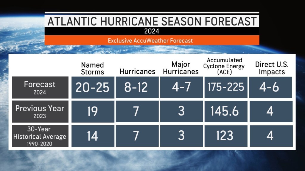
The AccuWeather 2024 Atlantic Hurricane Season Forecast calls for 20 to 25
named storms. Eight to 12 of those storms are forecast to strengthen into
hurricanes. Four to six storms could directly impact the United States.
“The 2024 Atlantic hurricane season is forecast to feature well above the
historical average number of tropical storms, hurricanes, major hurricanes,
and direct U.S. impacts,” said AccuWeather Lead Hurricane Forecaster Alex
DaSilva. “All indications are pointing toward a very active and potentially
explosive Atlantic hurricane season in 2024.”
With multiple factors and early warning signs pointing to a super-charged
hurricane season, DaSilva said 2024 could go down in the record books.
“There is a 10 to 15 percent chance of 30 or more named storms this year.
Surpassing 30 would break the record set in 2020,” said DaSilva.
AccuWeather’s forecast calls for a dramatic shift from the 2023 Hurricane
Season. Nineteen storms were named in the Atlantic basin, but only four had
direct impacts in the United States last year. Hurricane Idalia hit Florida as a
Category 3 storm in August. Tropical Storm Harold soaked southern Texas in
August. Tropical Storm Ophelia brought gusty wind and rough surf to North
Carolina in September. Lee swiped the New England Coast as a tropical
rainstorm, before making landfall in Nova Scotia.
DaSilva said there are four driving forces contributing to the forecast for a
super-charged hurricane season that could exhaust the primary list of Atlantic
storm names.
Ocean Temperatures Off The Charts
Warm water can act as fuel for tropical systems to rapidly intensify into
powerful and destructive hurricanes.
“Sea-surface temperatures are well above historical average across much of
the Atlantic basin, especially across the Gulf of Mexico, Caribbean, and the
Main Development Region,” DaSilva explained.
AccuWeather Chief Meteorologist Jon Porter said there is high confidence
that that sea-surface temperatures across the Atlantic basin will remain well
above the historical average throughout the 2024 hurricane season.
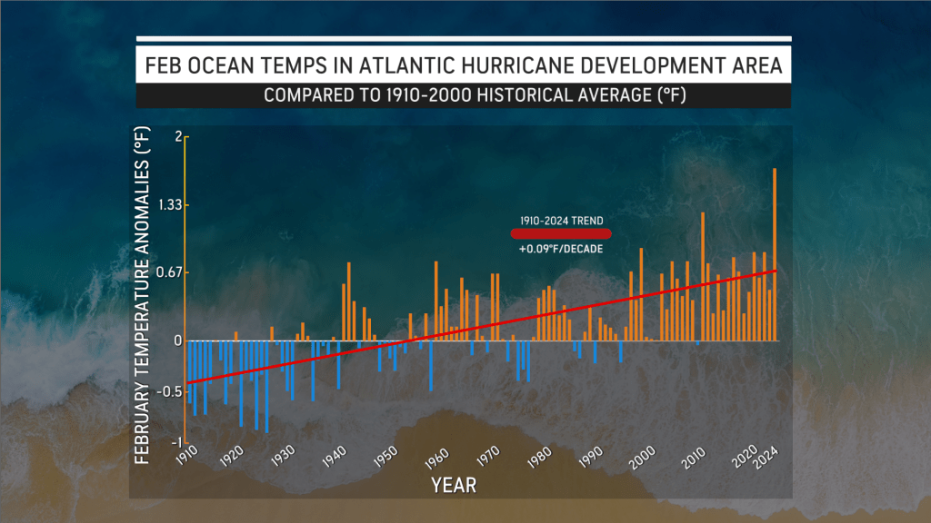
“When you look back at historical sea surface temperature in the Atlantic’s
Main Development Region, recent average water temperatures jump off the
chart. They are the highest observed this early in the season in the available
records,” said Porter. “This is a very concerning development considering this
part of the Atlantic Ocean is where more than 80 percent of the storms form
which go on to become tropical storms or hurricanes.”
Atlantic water temperatures observed this month were just as warm or
warmer than they were during March 2005 and March 2020. Both years
experienced catastrophic hurricane impacts in the United States.
Thirty named storms formed in the Atlantic basin in 2020, the highest on
record. There were 28 named storms in 2005. Hurricane Katrina caused
catastrophic damage along the Gulf Coast in 2005. A record-shattering 11
named storms made landfall in the United States in 2020, including
hurricanes Laura, Delta, and Zeta in Louisiana.

The unusually warm waters could also support tropical systems forming
before the official start of the 2024 Hurricane Season on June 1. Lingering
warm waters in the fall could also contribute to tropical threats in November
when activity typically winds down. The hurricane season officially ends on
November 30.
The Ocean Heat Content, or depth of warm waters across the Atlantic basin,
is forecast to be very high during this hurricane season. Deep, warm water
can promote the rapid intensification of tropical storms and hurricanes.
Flipping from El Niño to La Niña
A shift underway in the Pacific Ocean could have major implications on
tropical activity thousands of miles away over the Atlantic Ocean.
Waters near the equator of the eastern Pacific are in the process of changing
from an El Niño pattern to a La Niña pattern by mid or late summer.
During an El Niño pattern, waters in the eastern Pacific are warmer than the
historical average. In La Niña, sea-surface temperatures in the eastern Pacific
are cooler than the historical average.
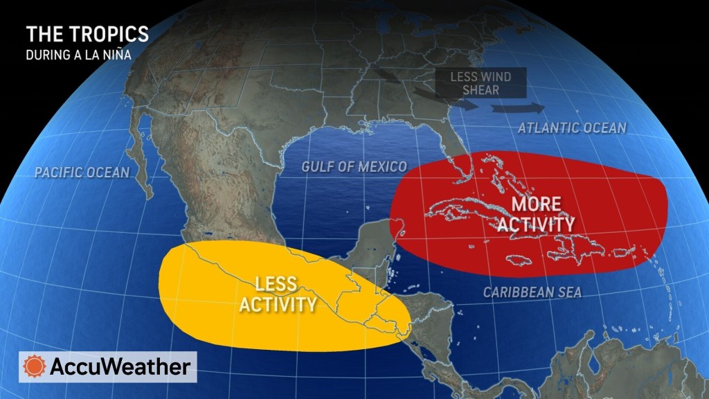
DaSilva said La Niña often leads to less disruptive winds, known as wind
shear, over most of the Atlantic basin. The combination of less wind shear and
warmer water provides prime conditions for tropical development.
“The faster the transition to La Niña occurs, the more active the hurricane
season is likely to be,” explained DaSilva.
Weather Patterns in Africa
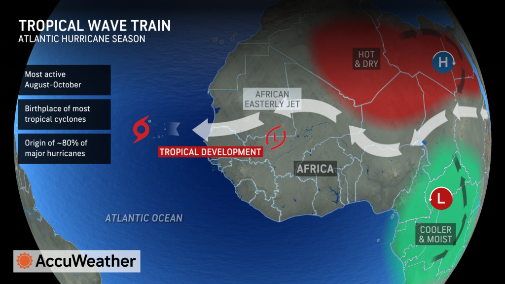
The expected transition to La Niña is forecast to promote a stronger African
easterly jet stream, which can boost the African monsoon.
A stronger African jet stream could support more periods of dry air moving off
the continent of Africa, which could hinder tropical development in the early
part of the hurricane season.
AccuWeather expert meteorologists warn that a stronger African Jet stream
could lead to more robust tropical waves later in the season, resulting in
additional opportunities for tropical storms to form.
Changes in Location and Strength of Steering Winds
The strength, orientation, and position of a feature known as the Bermuda-
Azores High pressure area can have a major influence on the formation of
tropical storms and hurricanes.
AccuWeather expert meteorologists say the Bermuda-Azores High can be
offset farther south and east compared to the historical average, due to
warmer sea-surface temperatures.
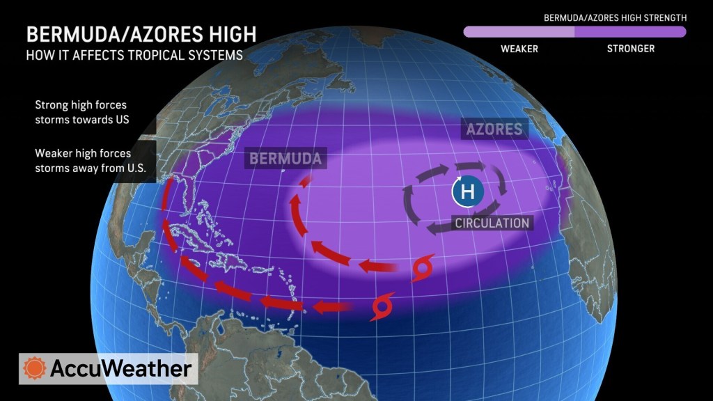
This placement can favor a period of re-curving tropical systems in the
western Atlantic when the high is weaker, and another period of storms
reaching the Caribbean and Gulf of Mexico when the high is stronger.
What Areas Face A Heightened Hurricane Risk
The team of expert meteorologists at AccuWeather reviewed data from
analog years, or past seasons when weather patterns were similar, to
determine what regions face a higher risk of direct landfalls in 2024.
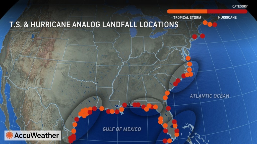
“The Texas coast, Florida Panhandle, South Florida and the Carolinas are at
a higher-than-average risk of direct impacts this season,” said DaSilva. “All
residents and interests along the U.S. coast, including Puerto Rico and the
Virgin Islands, should have a hurricane plan in place and always be fully
prepared for a direct impact.”
Not Enough Names?
With AccuWeather expert meteorologists forecasting 20-25 named storms this
season, the standard list of Atlantic storm names may not be long enough.
The alphabet has 26 letters, but the list skips Q, U, X, Y and Z.
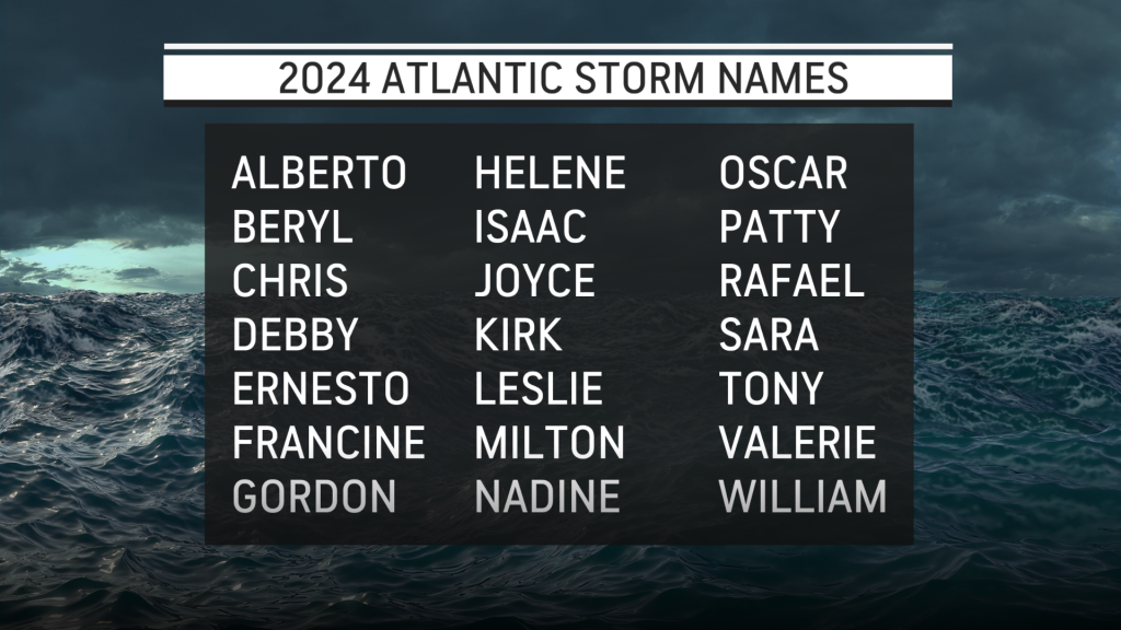
The Greek alphabet was used during the 2020 hurricane season after the first
21 storm names were used, but the practice has since ended.
The World Meteorological Organization now has a supplemental list of
additional names if all 21 names on the Atlantic basin list are used. This could
be the first year that the new supplemental list is needed.
Climate Change Connection
In addition to the weather patterns and early warning signs pointing to a
super-charged hurricane season, AccuWeather meteorologists say impacts
from climate change are increasing the odds of devastating landfalls.
“We do not see a relationship yet between global warming and the total
number of storms, the increase we are seeing is in the intensity of storms,”
said AccuWeather Senior Meteorologist Brett Anderson. “Climate change is
clearly playing a role with the notable uptick in the number of storms
becoming major hurricanes in the Atlantic basin and how rapidly they
intensify, especially over the past 10-20 years.”
Anderson says there is a clear trend of hurricanes unleashing more heavy
rainfall, as well as pushing more storm surge into coastal areas.
“The warming of the oceans also causes sea levels to rise. The volume of
water increases as temperatures rise. Thermal expansion, combined with the
melting of land-based glaciers due to climate change, has resulted in a steady
rise in sea level, especially along portions of the U.S. East Coast,” said
Anderson. “The same exact landfalling hurricane, in terms of strength and
track with a similar tide, will produce significantly more coastal flooding along
exposed areas, compared to a storm 30 to 50 years ago. Water is the number
one killer with hurricanes.”
AccuWeather Senior Storm Warning Meteorologist Billy Clark said experts are
also studying other factors that could contribute to more favorable conditions
for tropical development.
“Warming caused by the 2022 Hunga Tonga Volcano, as well as less Saharan
dust leading to more solar energy reaching the ocean’s surface, could all be
contributors,” said Clark. “This is all in addition to the gradual underlying
warming caused by increased greenhouse gasses like carbon dioxide and
methane. The same record-warm Atlantic Ocean that led to the second
warmest winter on record in Europe will now be the fuel for this potentially
volatile hurricane season.”
Why It’s Time To Prepare
With more people living and building in coastal areas along the Atlantic and
Gulf of Mexico, AccuWeather expert meteorologists say early preparation and
planning is key this year.
“Any storms that do form will have the potential to rapidly strengthen given the
correct atmospheric setup, even close to land, due to the exceptionally warm
waters. Early season storms are a threat again this year,” said AccuWeather
Chief Meteorologist Jon Porter. “There will also be an elevated risk for major
hurricanes. Texas and Louisiana are areas that have not been targets for
hurricanes in the last couple years; we think that may change. There’s a lot to
watch and be concerned about. How fast and how strong the La Niña comes
on as we head into the peak of the hurricane season will be a major factor.”
One measure of overall tropical activity and intensity throughout a hurricane
season is ACE, or Accumulated Cyclone Energy. Long-lived and stronger
hurricanes can generate a large amount of ACE, while short-lived tropical
storms only generate a small amount of ACE.
AccuWeather’s team of expert meteorologists predicts an Accumulated
Cyclone Energy of 175-225. The historical average of ACE is 123.
ACE measures the intensity and overall activity of tropical systems in the
Atlantic Basin throughout the year, making it a reliable way to quantify the true
strength of a hurricane season.
With the trend of more billion-dollar weather disasters happening in America,
Porter says a super-charged hurricane season could have major economic
impacts.
Hurricane Idalia caused an estimated $18 billion to $20 billion in damage and
economic impacts in Florida and across the southeast in 2023, according to
AccuWeather experts.
The record-breaking 2020 hurricane season, with 11 different landfalls in the
United States caused an estimated $60 billion to $65 billion dollars in damage
and economic losses, according to AccuWeather experts.
Additional AccuWeather Resources:


