


AccuWeather meteorologists are available 24/7 to provide further insights and updates on evolving weather conditions. Please contact pr@accuweather.com during regular business hours, or support@accuweather.com or call AccuWeather’s Media Hotline at (814)-235-8710 at any time to arrange interviews with AccuWeather experts or to request the most updated graphics for print or broadcast.
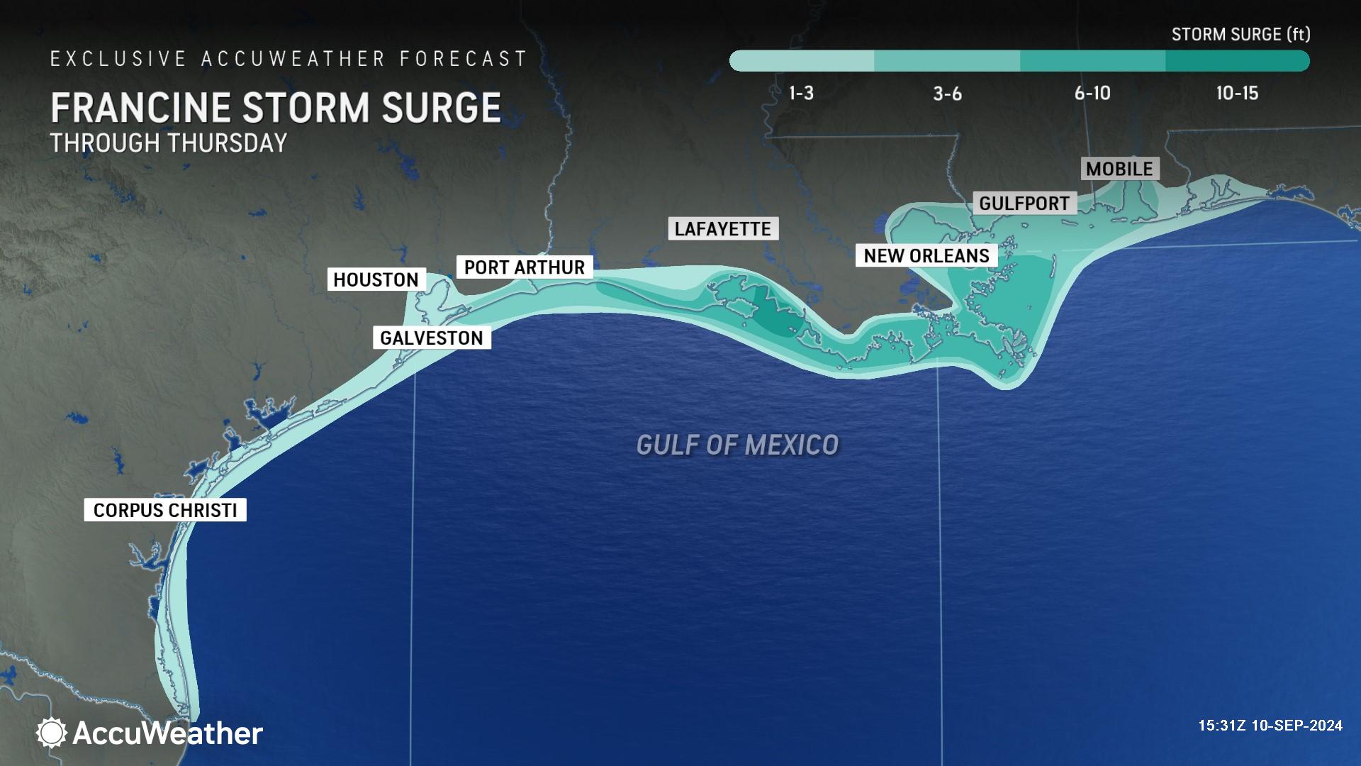
15 feet of life-threatening storm surge is possible when Francine slams the Gulf Coast
Sept. 10, 2024

> AccuWeather is forecasting 10-15 feet of storm surge along the Louisiana coast
where Francine makes landfall on Wednesday

> Flash flooding is likely with forecast of 8-12 inches of rainfall expected

> Tornadoes embedded in rain bands are possible east of the storm track
AccuWeather Global Weather Center – Sept. 10, 2024
AccuWeather expert meteorologists say Francine is forecast to intensify into a Category 2 hurricane with maximum sustained winds of 96-110 miles per hour in the next 24 hours before slamming the Louisiana coast with life-threatening storm surge.
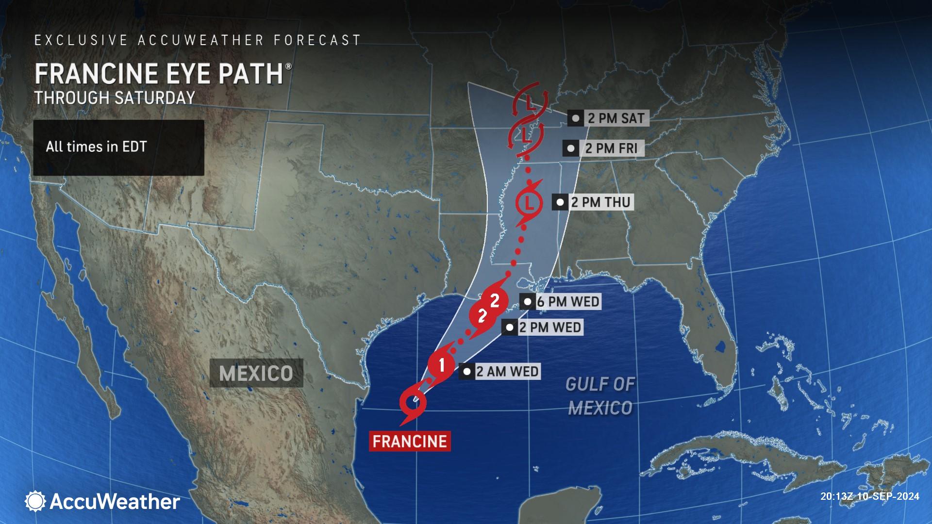
“While the National Hurricane Center and some other sources lowered their wind intensity forecast to a Category 1 hurricane, AccuWeather expert meteorologists have maintained their forecast of Francine reaching Category 2 intensity prior to landfall,” explained AccuWeather Chief Meteorologist Jon Porter. “This is due to the fact that the storm will spend time in an environment with very warm water, high ocean heat content, and low wind shear through Wednesday morning.”
Porter said families and businesses in the New Orleans region should not underestimate the impacts from Francine.
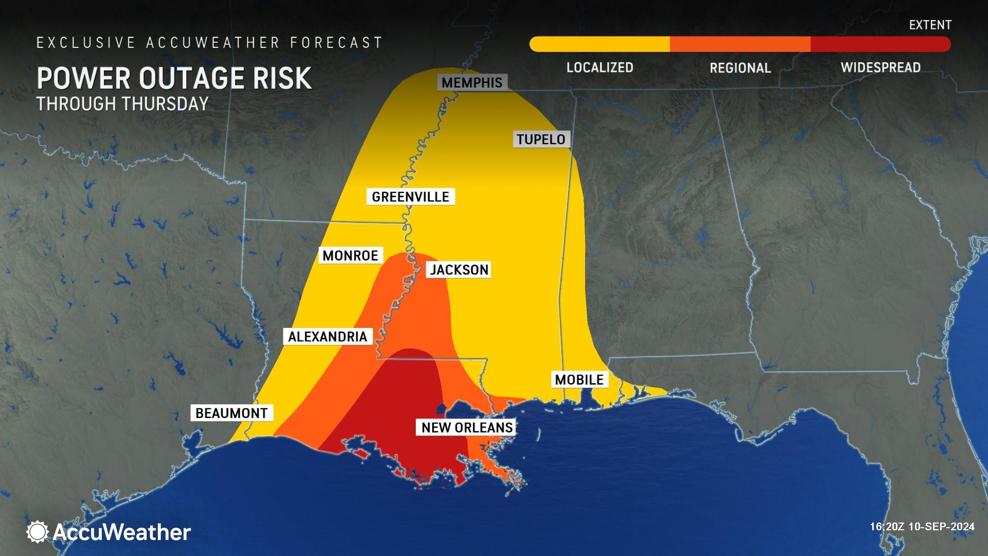
“AccuWeather hurricane experts are becoming increasingly concerned about the risk for damaging winds in the densely populated New Orleans metropolitan area,” Porter said. “Should Francine pass closer to the city, the storm's eyewall, the most intense part of the storm can pass near or over parts of the city, which would increase the risk for wind gusts of 80-100 mph. Additionally, in such a situation, the increased forward speed of the storm would add to the risk for damaging winds, especially during Wednesday evening. This can result in the risk for widespread and even long-lasting power outages. People and businesses are strongly encouraged to prepare for such impacts and have extra food and supplies should power be interrupted for several days. There are a lot of other headlines in the news this week. We are concerned that this storm is not getting enough attention and that some people may be caught off guard by the strength and damaging impacts from Francine.”
AccuWeather expert meteorologists say Francine could produce a widespread zone of 6-10 feet of storm surge along much of the Louisiana coast and parts of western Mississippi. AccuWeather Chief On-Air Meteorologist Bernie Rayno said a life-threatening 10-15 feet of storm surge is possible where Francine makes landfall.
“The worst of the storm surge will be to the east of the center of circulation where Francine makes landfall. Ten to 15 feet of storm surge can cause serious damage,” said Rayno.
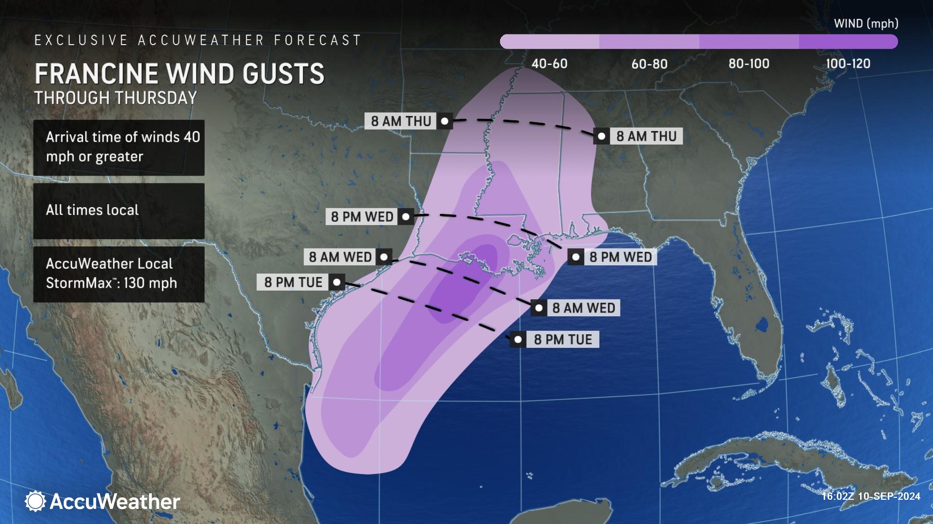
AccuWeather expert meteorologists are forecasting 100-120 mph winds when Francine approaches the Louisiana coast and makes landfall on Wednesday. The AccuWeather Local StormMax™ is 130 mph.
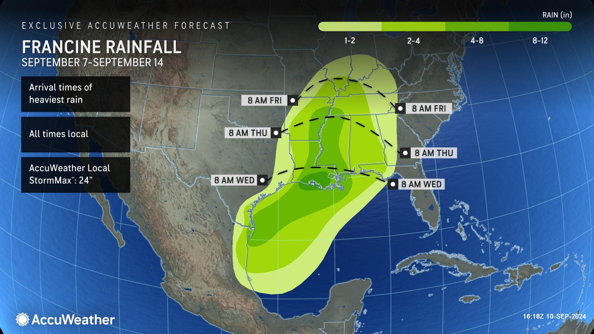
There will be a widespread 4-8 inches of rainfall across much of Louisiana, eastern Arkansas, western Mississippi and southwest Tennessee. A zone of 8-12 inches of rainfall is forecast across a pocket of southern and central Louisiana. The AccuWeather Local StormMax™ is 24 inches.
“We’re quite confident that Texas is going to avoid a direct landfall from Francine. That dip in the jet stream will push the storm to the north and east toward the Louisiana coast. There will still be hazardous conditions at beaches across Texas,” said AccuWeather Lead Hurricane Expert Alex DaSilva. “Once Francine moves inland and slows down, a dip in the jet stream and wind shear could enhance rainfall over Louisiana. We’re concerned about the threat of flash flooding that could extend far inland.”
Disruptive wind shear and dry air have prevented Francine from rapidly intensifying Tuesday morning and early afternoon, but AccuWeather expert meteorologists say there is a window of potential for Francine to rapidly intensify before making landfall.
“With these extremely warm waters and the risk for rapid intensification, it’s best for people along the Louisiana coast to be prepared for a higher impact storm,” said Porter.
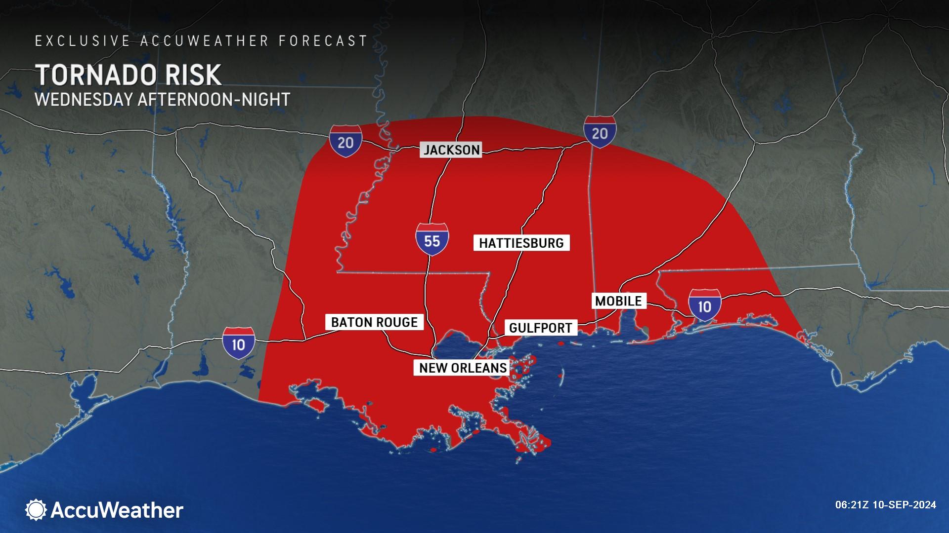
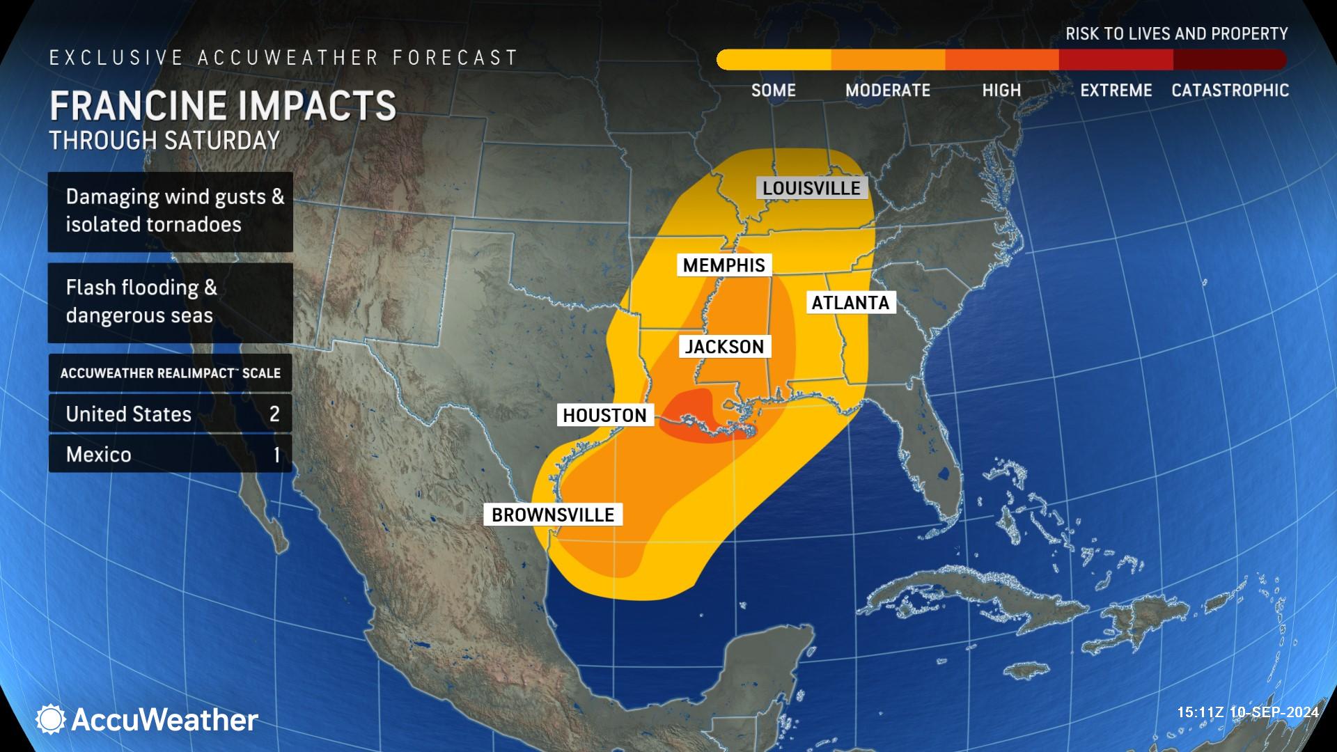
Along with the threat of heavy rainfall and flash flooding, AccuWeather experts say there will be a risk of tornadoes embedded in rain bands to the east of the storm track on Wednesday. The tornado threat will expand to the east on Thursday as Francine pushes farther inland. Because some dry air has become entrained into Francine's circulation, it may increase the number and intensity of severe thunderstorms, which could boost the number of tornadoes.
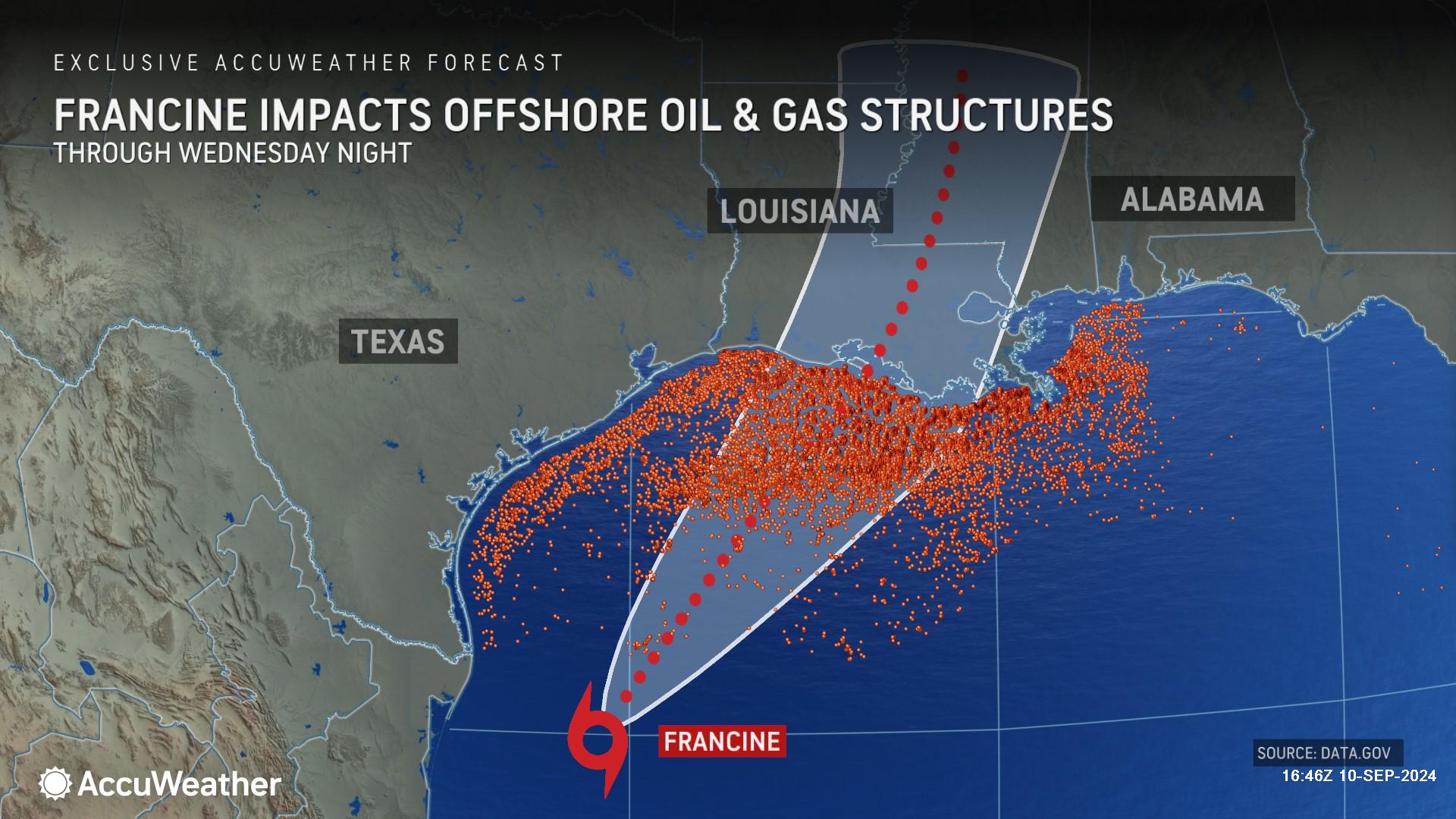
Francine will also impact offshore energy operations along the Gulf Coast.
“Francine is forecast to track directly through an area with hundreds of offshore gas and oil platforms,” said DaSilva. “Much of this infrastructure is built to withstand major hurricanes. We are not anticipating extensive damage, but operations are being suspended and disrupted until the storm passes.”
Francine is a 2 on the AccuWeather RealImpact™ Scale for Hurricanes in the United States, which warns of moderate flooding, significant wind damage to small buildings and mobile homes, as well as tree damage, power outages and significant property damage from coastal inundation.
In contrast to the Saffir-Simpson Hurricane Wind Scale, which classifies storms by wind speed only, the AccuWeather RealImpact™ Scale is based on a broad range of important factors. In order to better communicate a more comprehensive representation of the potential impact of a storm on lives and livelihoods, the scale covers not only wind speed, but also flooding rain, storm surge and economic damage and loss. Some of these hazards, such as inland flooding and storm surge in many storms, result in more deaths and economic loss than wind.
AccuWeather was the first known source to issue a forecast track and intensity forecast for this tropical threat Saturday afternoon, roughly 24 hours before the National Hurricane Center issued its first forecast track Sunday afternoon.
“The Gulf coast has already been hit hard by two billion-dollar weather disasters this year. Francine will likely be the next billion-dollar storm in America,” said Porter. “Impacts from Francine could be felt nationwide as operations are being disrupted at offshore drilling rigs, refineries and shipping ports along the Gulf Coast.”
AccuWeather’s preliminary estimate of the total damage and economic loss from Hurricane Beryl in July in the United States is $28-32 billion. AccuWeather’s Preliminary Estimate of the Total Damage and Economic Loss from a devastating windstorm that blasted the Houston area in May is $5-7 billion.
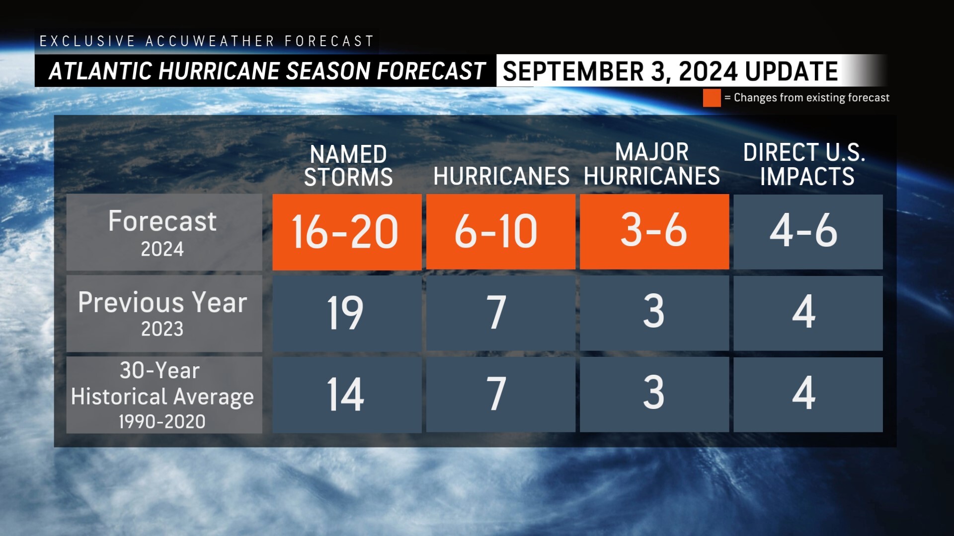
AccuWeather was the first known source to reduce the forecast for the number of named storms, hurricanes and major hurricanes expected during the 2024 Atlantic Hurricane season following the first Labor Day weekend without a named storm in decades.
AccuWeather is now forecasting;
> 16-20 named storms
> 6-10 hurricanes
> 3-6 major hurricanes
> 4-6 direct impacts to the United States
“This has evolved into a very unusual hurricane season. This time of year, we’re typically dealing with long-track hurricanes that form far out in the Atlantic basin and you have days to track it and prepare for the impacts. Francine is more of a home-grown type of storm,” said Rayno.
AccuWeather Forecast Graphics
Additional AccuWeather Resources:
Hurricane Tracking & Storm Radar
Francine bearing down on Louisiana, to strike as strengthening hurricane
LIVE: Hurricane warning in Louisiana as Francine nears US
5 reasons behind the historic absence of tropical storms this hurricane season
AccuWeather Reduces Forecast for Number of Named Storms and Hurricanes During 2024 Atlantic Hurricane Season
Rapidly Intensifying Hurricanes Near Coastline Pose Major Threat To US This Season


