AccuWeather meteorologists are available 24/7 to provide further insights and updates on evolving weather conditions. Please contact pr@accuweather.com during regular business hours, or support@accuweather.com or call AccuWeather’s Media Hotline at (814)-235-8710 at any time to arrange interviews with AccuWeather experts or to request the most updated graphics for print or broadcast.
Flooding and tornado threat expands as Francine pushes northward
Sept. 12, 2024
AccuWeather expert meteorologists are alerting the public of a flash flooding and
tornado threat as Francine moves inland, as well as a second tropical threat
brewing off the coast of the southeast United States.
AccuWeather Global Weather Center – Sept. 12, 2024
Flash flooding, destructive winds, life-threatening storm surge, and the threat of spin up tornadoes will impact coastal Louisiana as Hurricane Francine approaches the Gulf coast.
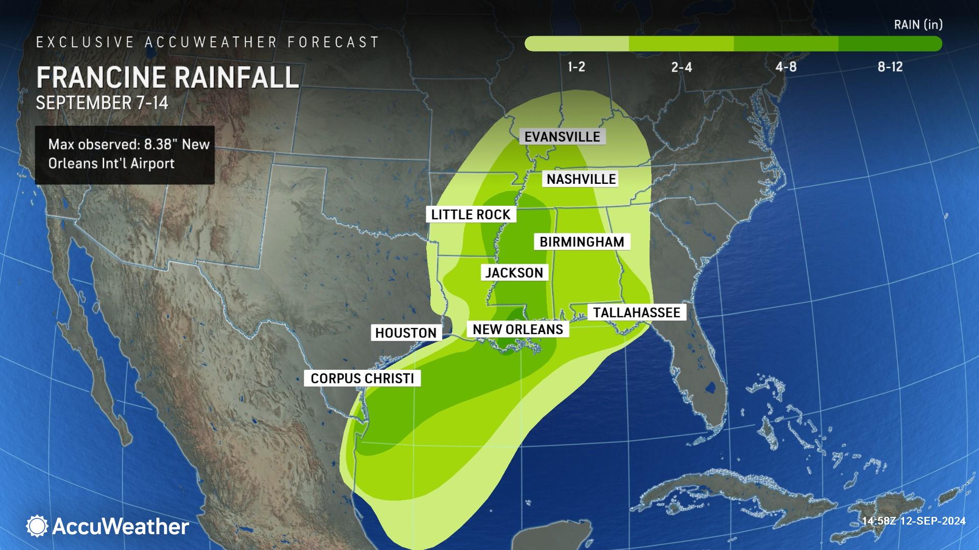
Francine slammed coastal Louisiana and the New Orleans metro area with hurricane-force wind gusts and relentless rainfall Wednesday afternoon as a Category 2 hurricane with maximum sustained winds of 100 mph.
“The New Orleans area was hit particularly hard with flooding,” said AccuWeather Chief Meteorologist Jon Porter. “Francine is the latest example of a hurricane intensifying in extremely warm waters right before making landfall. This is the exact intensification threat that AccuWeather expert meteorologists have been warning the public about since March. This is an alarming trend that everyone along the Atlantic and Gulf coasts need to be prepared for.”
AccuWeather was the only known source to consistently forecast Francine intensifying to Category 2 hurricane strength before making landfall, starting Monday afternoon. AccuWeather was the first known source to issue a forecast track and intensity forecast for this tropical threat on Sept. 7, roughly 24 hours before the National Hurricane Center issued its first forecast track Sunday afternoon.
Francine marks the 8th consecutive year that a Category 2, or stronger, hurricane on the Saffir-Simpson hurricane wind scale has hit the continental United States.
Hazardous risks shift to the north
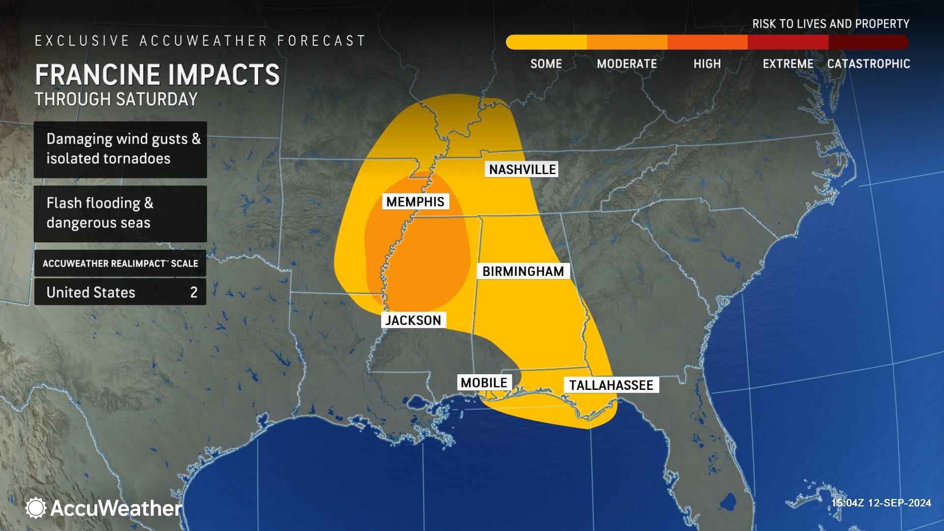
The risk of flooding rainfall and wind gusts of 40-60 mph is spreading across parts of eastern Louisiana, much of Mississippi, western and central Alabama, eastern Arkansas, southwestern Tennessee and parts of the Florida Panhandle through Thursday night.
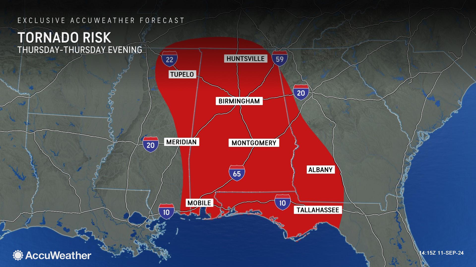
AccuWeather expert meteorologists say some dry air has become entrained into Francine's circulation, which may increase the number and intensity of severe thunderstorms, which could boost the number of tornadoes through Thursday night and possibly continue into early Friday. The main risk of tornadoes is north and east of the center of the storm.
“Francine has slowed down dramatically. That’s going to boost rainfall and flooding concerns,” said AccuWeather Chief On-Air Meteorologist Bernie Rayno. “The threat for severe weather is east of the storm track. The heavy rain and flooding threat will be along the center and west side of the storm track. We could see a tornado threat expand as far inland as the Nashville area as warmer air pushes north.”
Unusual hurricane season
AccuWeather Lead Hurricane Expert Alex DaSilva says the 2024 hurricane season has not followed the typical trends and patterns expected during a year influenced by a developing La Niña pattern.
“It has not been a particularly busy hurricane season up to this point, but it has been a very impactful season,” DaSilva said. “We expect the tropics to be quite active as we head into October. It’s important that everyone remains vigilant and prepared for rapidly developing storms in areas that are not considered typical for this time of year.”
Rayno describes the first half of the 2024 hurricane season as “odd.” Tuesday marked the climatological peak of the season.
“This has been a very weird hurricane season so far this year. In the early part of the season, you typically see homegrown development near the U.S. This year, Beryl, Debby and Ernesto were long-track storms that formed early in the season,” Rayno explained. “Francine developed in September close to the U.S. which is not typical. This hurricane season seems to have flip-flopped patterns.”
Brewing threats in the Atlantic
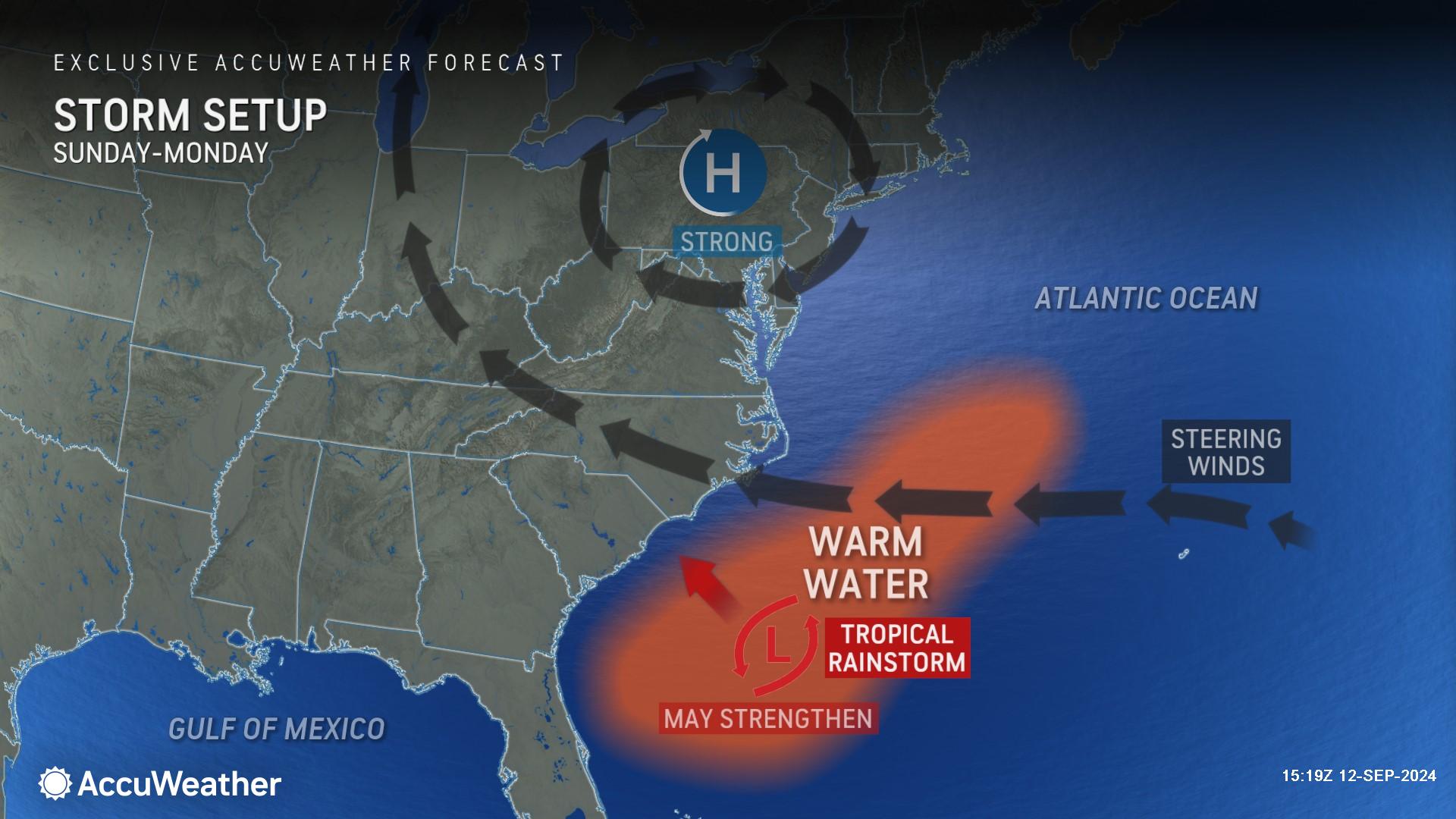
AccuWeather expert meteorologists are closely monitoring a new ‘homebrew’ tropical threat emerging along the Southeast coast.
A ‘homebrew’ storm is one that forms close to the coast of the U.S. and is most common during the early part of the hurricane season.
AccuWeather expert meteorologists have begun to refer to this potential threat as a tropical wind and rainstorm to raise public awareness of the anticipated impacts to parts of the Southeast.
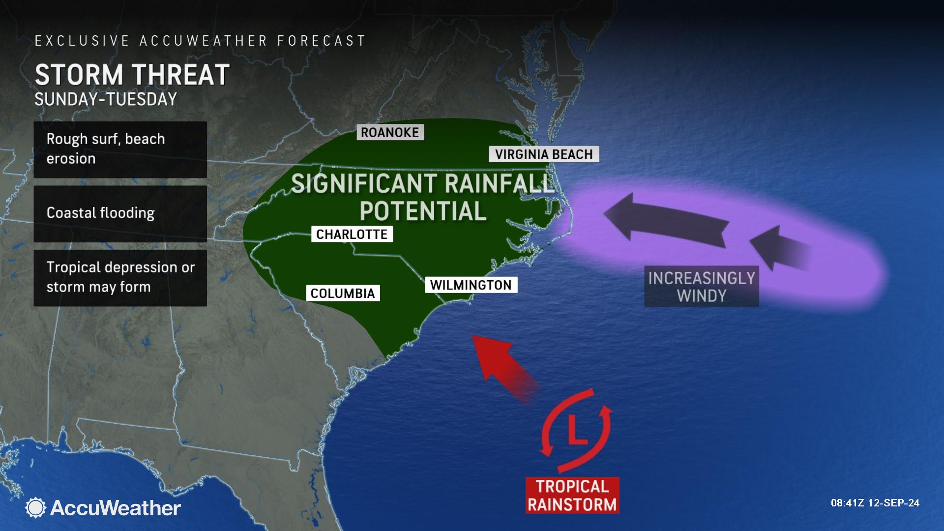
Some of Francine's energy will transfer to the warm Gulf Stream waters just off the East Coast of the U.S. this weekend, where a storm will brew and likely take on at least some tropical characteristics this weekend.
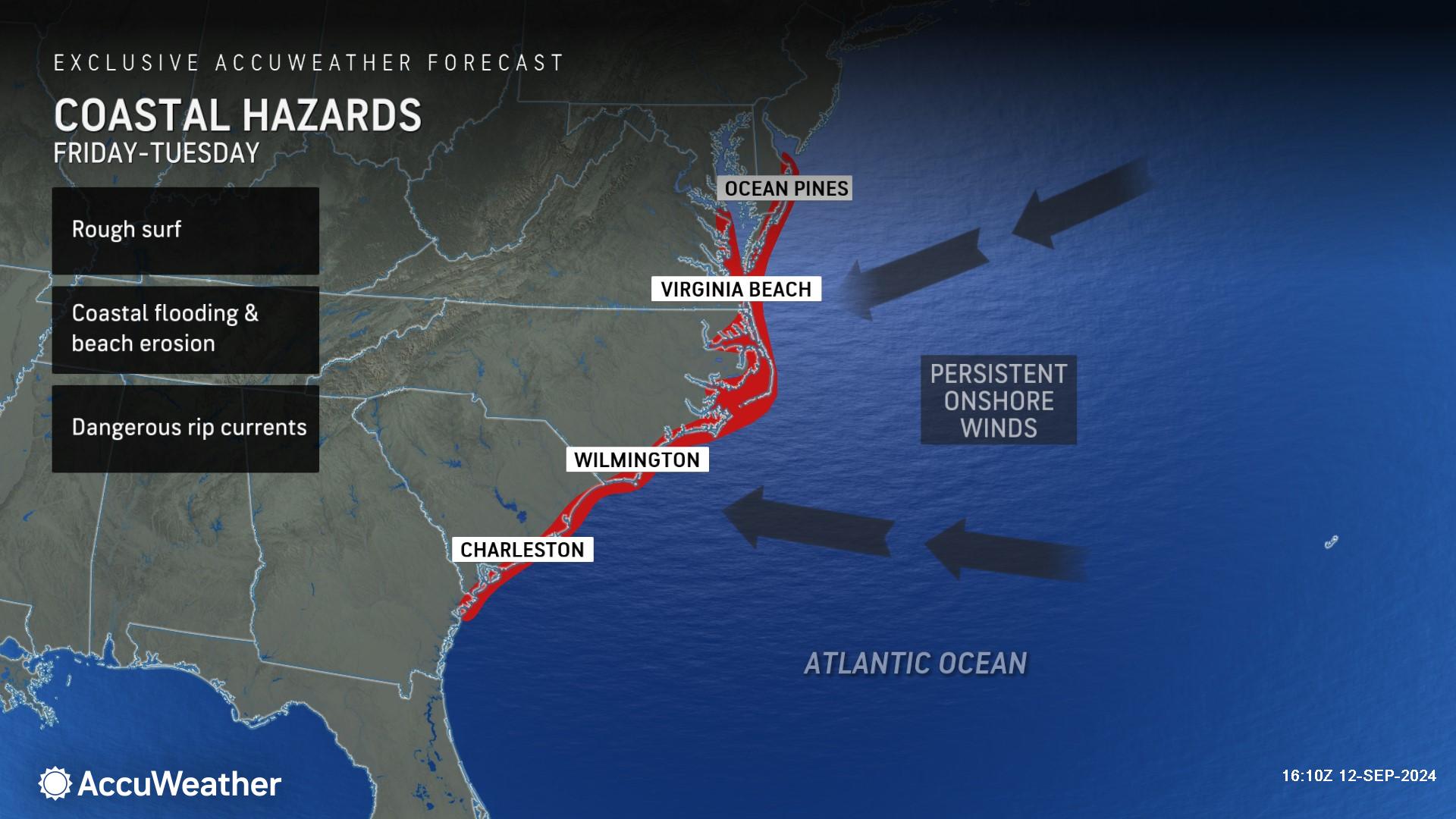
DaSilva says people along the coast of the Carolinas should be prepared for impacts that would be expected from a landfalling tropical storm, even if it does not get named.
"We continue to monitor the area just off the Carolina and Georgia coasts for tropical development this weekend to early next week,” DaSilva said. "This system has the potential to spread heavy rain to the Carolinas and perhaps the lower part of the mid-Atlantic as it drifts to the west and northwest."
DaSilva says this tropical threat does not seem likely to have enough time to develop into a hurricane.
A period of gusty winds will lead to building seas, rough surf, strong rip currents and beach erosion in coastal areas. There may also be the threat of severe thunderstorms that produce a few tornadoes and waterspouts. Weak steering breezes may cause the storm to stall after moving inland over the Southeast states.
Areas of drought have been increasing over the interior East, including the southern Appalachians and the Ohio Valley, so any non-flooding rainfall would likely be beneficial.
High pressure is likely to remain strong enough to keep tropical downpours away from New England next week, but most likely, moisture will erode the dry conditions in the mid-Atlantic and Great Lakes areas from mid- to late week.
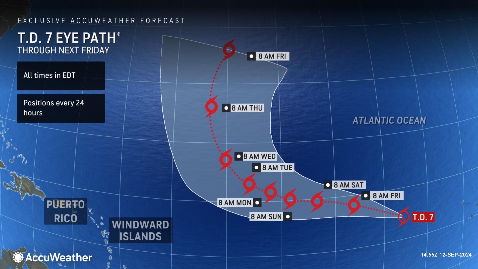
The next two names on the list of tropical storms for the 2024 Atlantic hurricane season are Gordon and Helene. A budding tropical cyclone over the eastern Atlantic will likely grab the name Gordon this week. The feature was upgraded to Tropical Depression 7 on Wednesday. While this system could become the next hurricane in the Atlantic, it may remain at sea for its duration.
“We expect Tropical Storm Gordon to form in the open Atlantic. This storm is expected to turn out to sea and likely won’t impact any populated areas,” said DaSilva.
AccuWeather expert meteorologists say families, businesses, emergency officials and government leaders need to be prepared for additional tropical threats that could rapidly develop in late September and October.
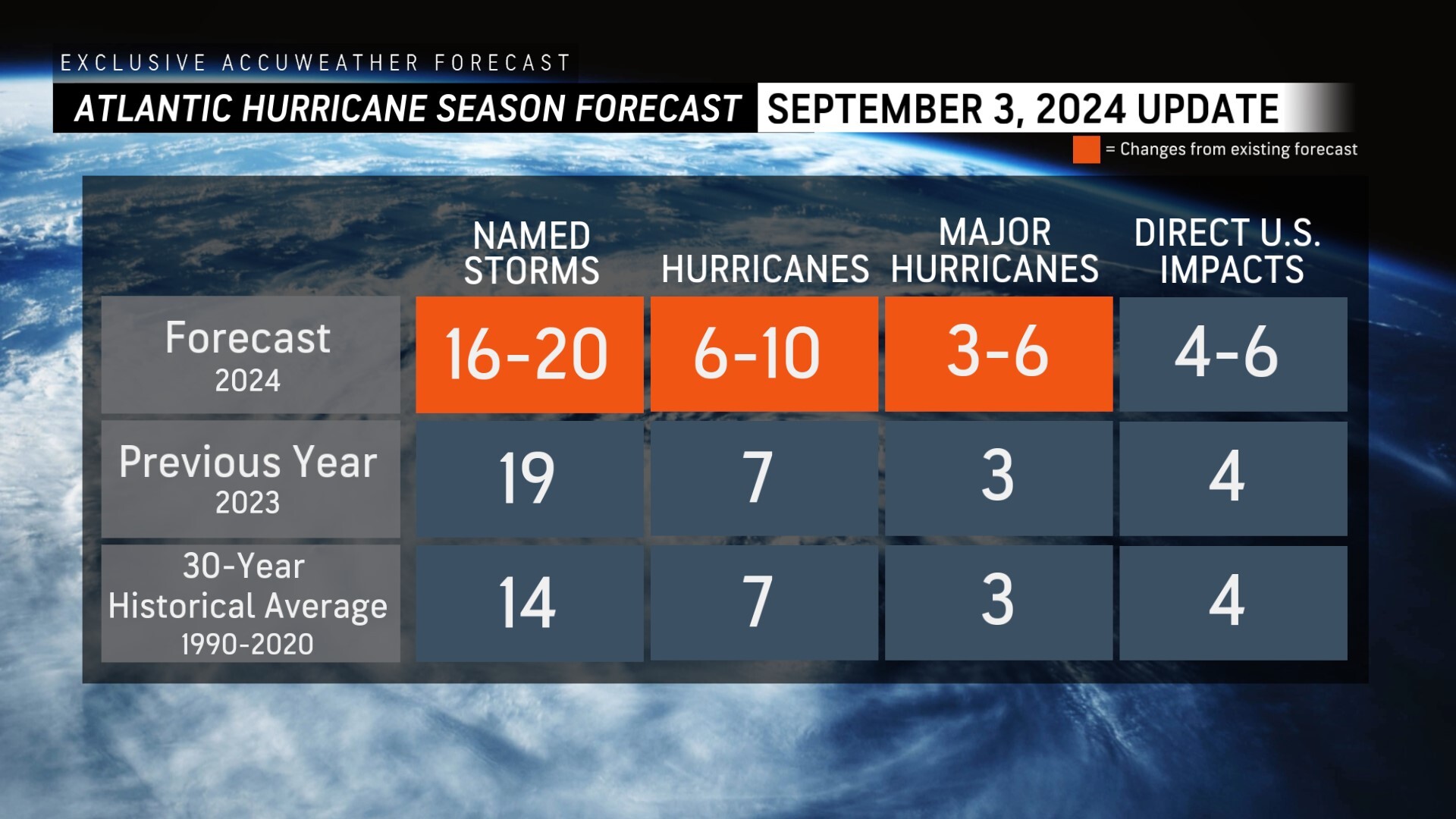
AccuWeather was the first known source to reduce the forecast for the number of named storms, hurricanes and major hurricanes expected during the 2024 Atlantic Hurricane season following the first Labor Day weekend without a named storm in decades.
AccuWeather Forecast Graphics
Additional AccuWeather Resources:
Hurricane Tracking & Storm Radar
Southern US braces for heavy rains and tornado threat as Francine moves inland
LIVE: Louisiana communities assess damage and begin cleanup after Francine
5 reasons behind the historic absence of tropical storms this hurricane season
AccuWeather Reduces Forecast for Number of Named Storms and Hurricanes During 2024 Atlantic Hurricane Season
Rapidly Intensifying Hurricanes Near Coastline Pose Major Threat To US This Season


