


AccuWeather meteorologists are available 24/7 to provide further insights and updates on evolving weather conditions. Please contact pr@accuweather.com during regular business hours, or support@accuweather.com or call AccuWeather’s Media Hotline at (814)-235-8710 at any time to arrange interviews with AccuWeather experts or to request the most updated graphics for print or broadcast.
Category 1 hurricane forecast to make landfall along the Gulf Coast this week
Sept. 8, 2024

AccuWeather Global Weather Center – Sept. 8, 2024
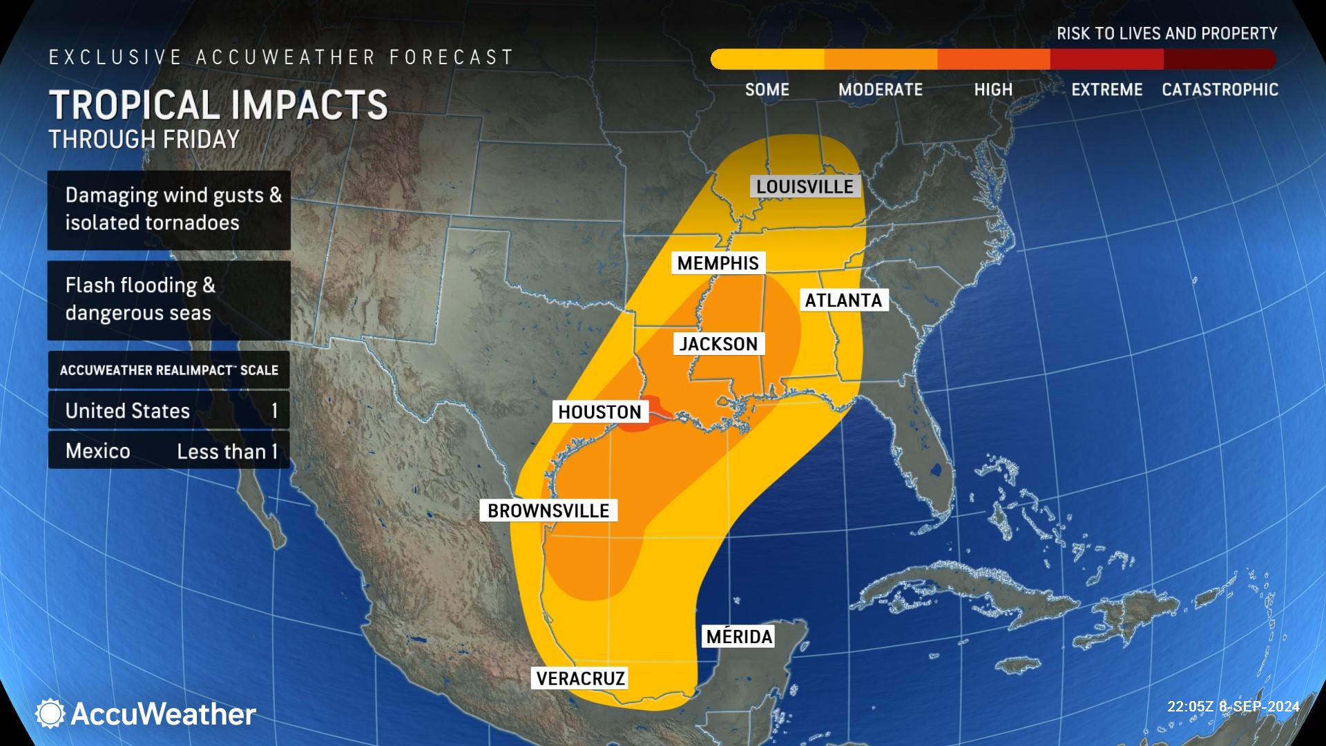
People across coastal Texas and Louisiana should prepare for the risk of flash
flooding, damaging wind gusts, destructive storm surge and tornadoes embedded
in rain bands as this brewing storm approaches the Gulf Coast.
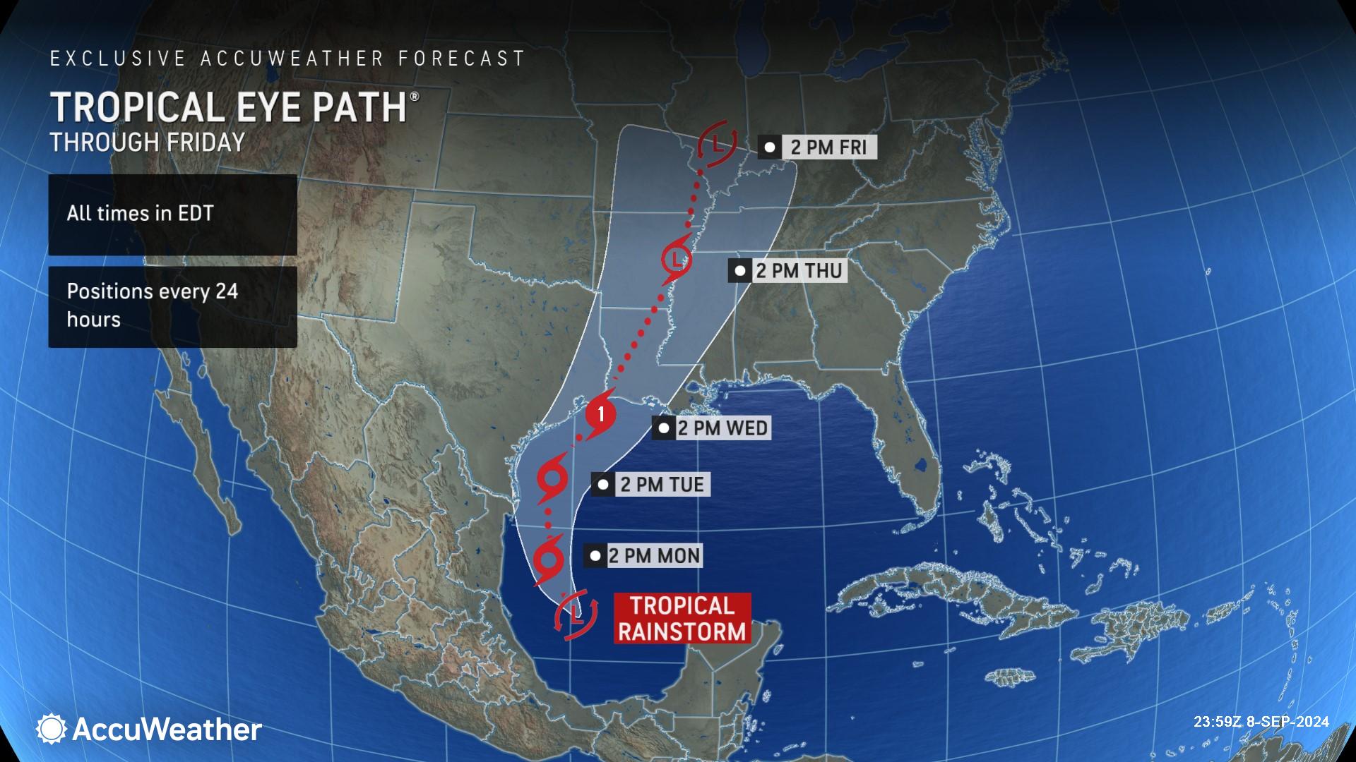
AccuWeather expert meteorologists say a tropical rainstorm brewing in the Gulf of Mexico is forecast to strengthen to a Category 1 hurricane with maximum sustained winds of 74-95 miles per hour on the Saffir-Simpson Hurricane Wind Scale before making landfall near the border of coastal Louisiana and Texas on Wednesday.
“People in parts of Texas and Louisiana need to be prepared for flooding rainfall, powerful wind gusts, storm surge and the potential for spin up tornadoes embedded in rain bands,” warned AccuWeather Chief Meteorologist Jon Porter. “This region has dealt with a lot of rainfall and flooding in the past week. With the ground already saturated, we’re concerned about an elevated risk of flash flooding and trees with weakened root systems toppling over in the wind when this storm makes landfall and pushes inland.”
AccuWeather was the first known source to issue a forecast track on Saturday afternoon, nearly 24 hours before the National Hurricane Center issued its first forecast track on Sunday afternoon. The next tropical storm name on the list for the 2024 Atlantic hurricane season is Francine.
Timeline for impacts
AccuWeather Lead Hurricane Expert Alex DaSilva said this brewing storm will encounter disruptive wind shear as it moves over extremely warm waters in the Gulf of Mexico.
“While the wind shear over this tropical rainstorm will increase as it approaches the northern Gulf Coast, near all-time record high sea-surface temperatures and ocean heat content could allow for rapid strengthening,” DaSilva explained. “We urge anyone with interests along the northern and western Gulf Coast to follow the progress of this rainstorm very closely.”
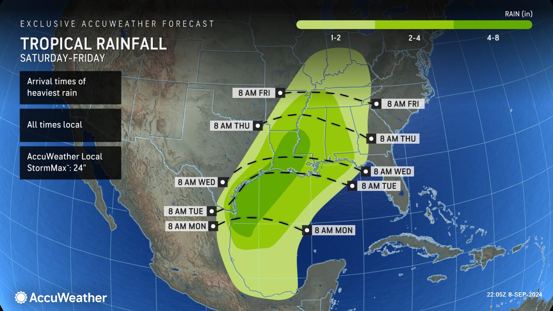
AccuWeather expert meteorologists say rounds of rain and thunderstorms have already spread into portions of the northeastern Mexican coastline, and a more persistent deluge of moisture is forecast to surge into southeast Texas, Louisiana, Mississippi and Alabama through Friday.
Bands of rain will begin to arrive along the far southern tip of Texas by Monday morning and are forecast to reach the Louisiana coastline by early Tuesday. AccuWeather expert meteorologists are forecasting a zone of 4-8 inches of rainfall across much of coastal Texas, as well as southeast and central Louisiana, and parts of western Mississippi. The AccuWeather Local StormMax™ is 24 inches. The threat of flash flooding will extend through parts of the Mississippi Valley through the week as the storm tracks inland.
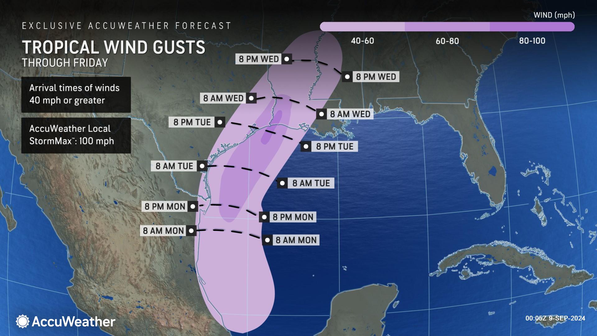
AccuWeather expert meteorologists say 60-80 mph wind gusts are expected along parts of the Gulf Coast through Thursday. In far southwestern Louisiana and far eastern Texas, wind gusts of 80-90 mph can occur with an AccuWeather Local StormMax™ of 100 mph. Impacts from wind will begin to subside as the storm loses wind intensity and tracks inland; however, rounds of rain and flash flooding will be possible along the Mississippi Valley into late week.
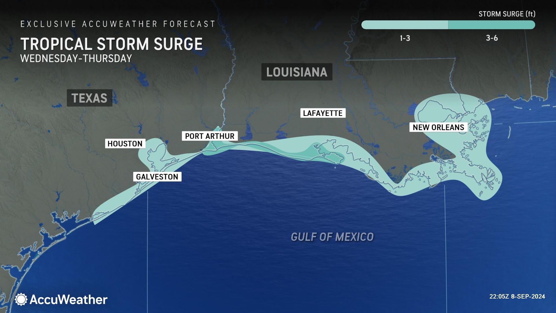
Families and businesses along the coastline from East Matagorda Bay, Texas, to Bay St. Louis, Mississippi, are being urged to prepare for the risk of 1-3 feet of storm surge. AccuWeather expert meteorologists say 3-6 feet of storm surge is possible closer to the point of landfall.
The AccuWeather RealImpact™ Scale for Hurricanes in the United States is a 1, which warns of localized flooding, damage to unanchored mobile homes, localized power outages and coastal inundation resulting in property damage.
The AccuWeather RealImpact™ Scale for Hurricanes in Mexico is a less than 1, which warns of limited damage from wind and rain, as well as coastal inundation resulting in some property damage.
In contrast to the Saffir-Simpson Hurricane Wind Scale, which classifies storms by wind speed only, the AccuWeather RealImpact™ Scale is based on a broad range of important factors. In order to better communicate a more comprehensive representation of the potential impact of a storm on lives and livelihoods, the scale covers not only wind speed, but also flooding rain, storm surge and economic damage and loss. Some of these hazards, such as inland flooding and storm surge in many storms, result in more deaths and economic loss than wind.
The Houston metropolitan area has already experienced multiple high-end weather events this year, including Hurricane Beryl in July and a powerful derecho in May, and cleanup efforts are still ongoing in some places. The risk of additional heavy rain and strong wind gusts could prolong these recovery efforts. A shift in the track farther west could increase the risk for tropical storm force winds in Houston and Galveston as well as heavy rainfall.
AccuWeather’s preliminary estimate of the total damage and economic loss from Hurricane Beryl in the United States is $28-32 billion.
Heavy rain and powerful wind gusts could also impact Lake Charles, Louisiana. Contractors imploded a high-rise office building in Lake Charles over the weekend that was left damaged and vacant for nearly four years after it took a direct hit from Category 4 Hurricane Laura in 2020.
Is more tropical trouble brewing in the Atlantic?
AccuWeather expert meteorologists are also monitoring two regions for potential tropical development in the Atlantic basin this week.
The first area of concern is located a few hundred miles west of Cape Verde and will slowly track westward across the open Atlantic over the upcoming days. From early to midweek, it will pose a high risk for development.
The second tropical wave is expected to emerge off Africa over the upcoming days and is projected to advance in a general westward direction as the week progresses. This feature poses a medium risk for development from mid- to late week.
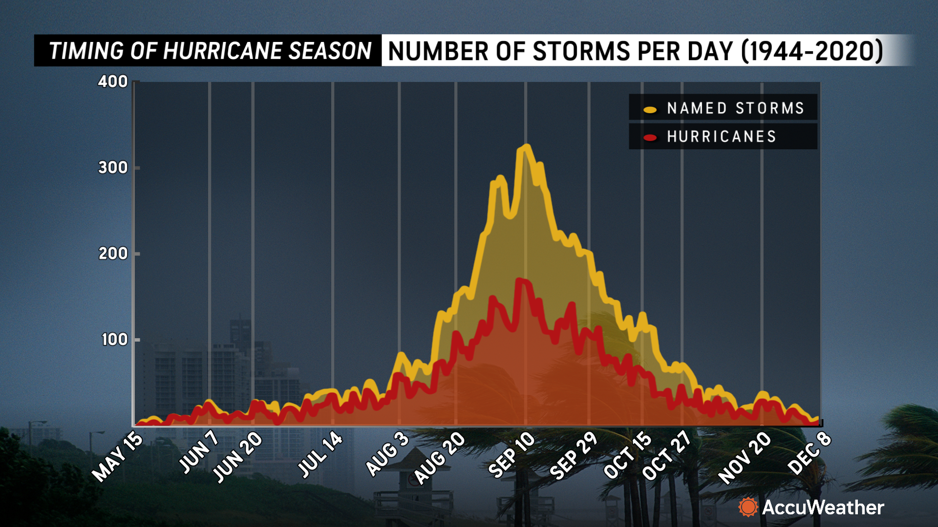
The climatological peak of the Atlantic hurricane season is Sept. 10.
“The tropics were unusually quiet during much of August and over the Labor Day holiday weekend, but the historic lull seems close to officially ending,” said Porter. “It’s crucial that hurricane emergency kits and supplies that were used during Hurricane Beryl in July across parts of the Texas coastline, and kits yet unused in the Upper Texas Coast and across Louisiana are checked and restocked this week. People in the path of this storm need to be ready for the threat of flooding and power outages that could leave them without electricity and air conditioning.”
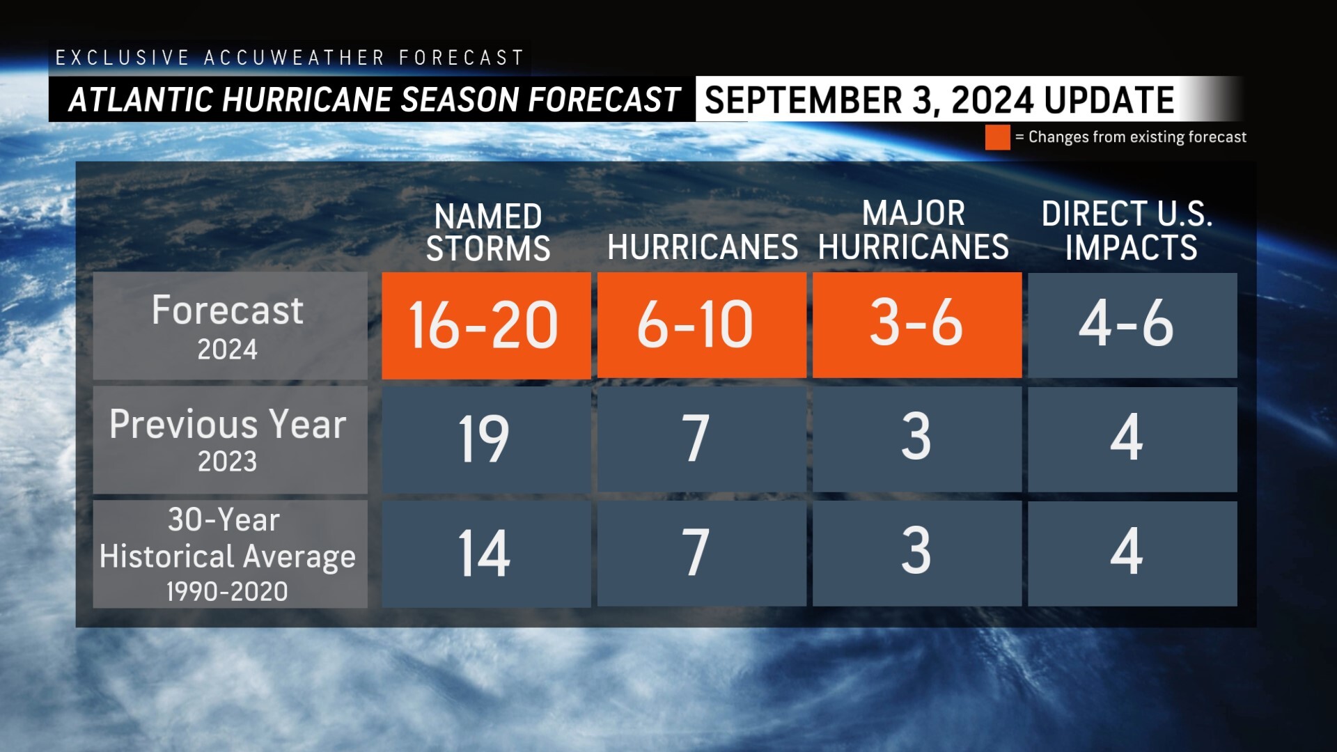
Following the first Labor Day weekend without a named storm in decades, AccuWeather was the first known source to reduce the forecast for the number of named storms, hurricanes and major hurricanes expected during the 2024 Atlantic Hurricane season.
AccuWeather is now forecasting;
> 16-20 named storms
> 6-10 hurricanes
> 3-6 major hurricanes
> 4-6 direct impacts to the United States
“It only takes one intense hurricane landfall to cause catastrophic damage. Even slow-moving tropical storms can cause widespread flooding,” warned Porter. “This is not the year to let your guard down. Water temperatures are incredibly warm and conditions are expected to become more conducive for hurricane development. This hurricane season is far from over.”
AccuWeather Forecast Graphics
Additional AccuWeather Resources:
Hurricane Tracking & Storm Radar
Tropical rainstorm in Gulf of Mexico has sights set on the southern US
5 reasons behind the historic absence of tropical storms this hurricane season
AccuWeather Reduces Forecast for Number of Named Storms and Hurricanes During 2024 Atlantic Hurricane Season
Rapidly Intensifying Hurricanes Near Coastline Pose Major Threat To US This Season


